CHAPTER XII.
LIASSIC AND OOLITIC, OR JURASSIC STRATA.
IN the previous chapter, I stated that the continental area in which lay the lakes of the epoch of
the New Red Marl, underwent partial submersion, during which our passage beds, called the Rhætic or Avicula contorta strata, were deposited. This sinking of the land going on by degrees,
resulted in the formation of groups of islands, round which, first the LIAS, and afterwards the
OOLITIC SERIES were deposited, the whole, on the Continent of Europe, and now often in Britain,
being grouped under the name of Jurassic formations.
The general stratigraphical relations of the larger masses of the Liassic and Oolitic series, in
the southern half of England, will be easily understood by reference to fig. 5, p. 25.
The high ground now called Wales and Herefordshire, undoubtedly formed part of one of these
islands; Dartmoor and other palæozoic elevations in Devon and Cornwall formed others; probably
the hilly regions of Derbyshire another; and, certainly, the Cumbrian mountains a fourth;
while there can be no doubt that parts of the south of Scotland, and the greater heights of the
Highlands, also stood as islands washed by the Liassic sea.
It is not, however, to be supposed that the actual
[Lower Lias. 167]
forms of these island territories were even approximately identical with those of the present
mountains, and the limits and orographic contours of these fragments of an old physical
geography can only be approximately guessed at. They have undoubtedly been subjected to
repeated disturbance and upheaval since the beginning of the deposition of the Lias, but after
these old palæozoic mountains first rose high into the air, they suffered so much from all the
agents of waste and degradation, that in Liassic and pre-Liassic times, I have no doubt they were
higher than now, and partly occupied more extended areas.
THE LOWER LIAS CLAY AND LIMESTONE is about 900 or 1,000 feet thick, where best developed
in England, and consists of beds of blue clay or shale (weathering brown), interstratified with
beds of blue argillaceous limestone, largely quarried in Leicestershire, Warwickshire, and
elsewhere, for hydraulic lime. These limestones, lying flat and unconformably on the upturned
and denuded edges of the Carboniferous Limestone, form splendid cliffs on the coast of
Glamorganshire, and, with the Rhætic beds, they are also well exposed in the coast section at
Lyine Regis. From thence, scarcely interrupted at the east end of the Mendip Hills, the Lower
Lias strikes north to the junction of the Severn and Avon, and again NE. and N. to the sea-coast of
Yorkshire, E. of the river Tees. Throughout this area it usually forms a flat or undulating
country, lying much in pasture land. The strata dip generally gently to the east, but are
sometimes for a space quite flat. Occasionally the limestones of the Lower Lias form a low
escarpment, generally facing west, and, almost invariably, the Maristome or Middle Lias makes
a similar and higher escarpment, the top
[168]
FIG. 35.
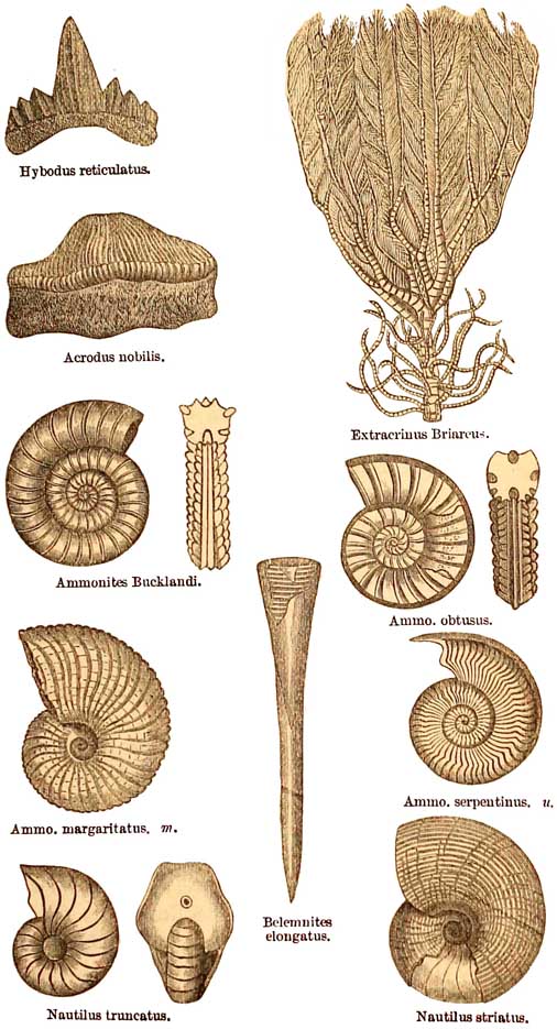
Group of Lias Fossils.
m. Middle Lias or Maristone. u. Upper Lias; all the rest Lower Lias.
[Middle Lias. 169]
of which is formed of a tough brown fossiliferous limestone, generally of only a few feet in
thickness, but nearly constant in its occurrence from Dorsetshire to Yorkshire, and the very
indefinite base of the Maristone forms the eastern boundary of the Lower Lias.
The Lower Lias clay and limestone of England is, as a whole, rich in fossils, the general
grouping of which cannot be more than noticed here in a cursory manner. These strata yield
Extracrinus among the Crinoids, (fig. 35); of Brachiopocla, a few species of Spiriferœ,
Terebratulœ, and Rhynchonellœ, and numbers of Lamellibranchiate molluscs, such as Gryphœa
incurva, Oysters, Pectens, Limas, Pinnas, Aviculas, Pholadomyas, and others. Having been
deposited mostly in deep sea, univalve shells are much less common, but of the Cephalopoda,
which are free swimmers, there are vast numbers of Ammonites, Belemnites, and Nautili (see
fig. 35), together with many fishes, and the great marine Enalosaurian reptiles, Ichthyosaurus
(fish-lizard) and Plesiosaurus (see fig. 36), and the insectivorous flying reptile,
Pterodactylus brevirostris.
THE MARLSTONE SERIES, or MIDDLE LIAS, which succeeds the Lower Lias clay, is generally
somewhat argillaceous below, graduating upward into a brown, ferruginous, soft, sandy rock,
with hard nodular bands, and a very marked brown ferruginous limestone at the top. It is rich
in many forms of Ammonite, Belemnite, Plagiostoma, Lima, Pinna, Pholadomya, Pecten, Modiola, Terebratula, and Rhynchonella, besides a very characteristic Spirifer (S. Walcotti,
fig. 36), one of the few remaining shells of that Palæozoic genus. Where the Lower Lias and
Maristone join, the strata graduate into each other, but through the central parts of England
these passage-beds are rarely clearly
[170 Lias Fossils]
FIG. 36.
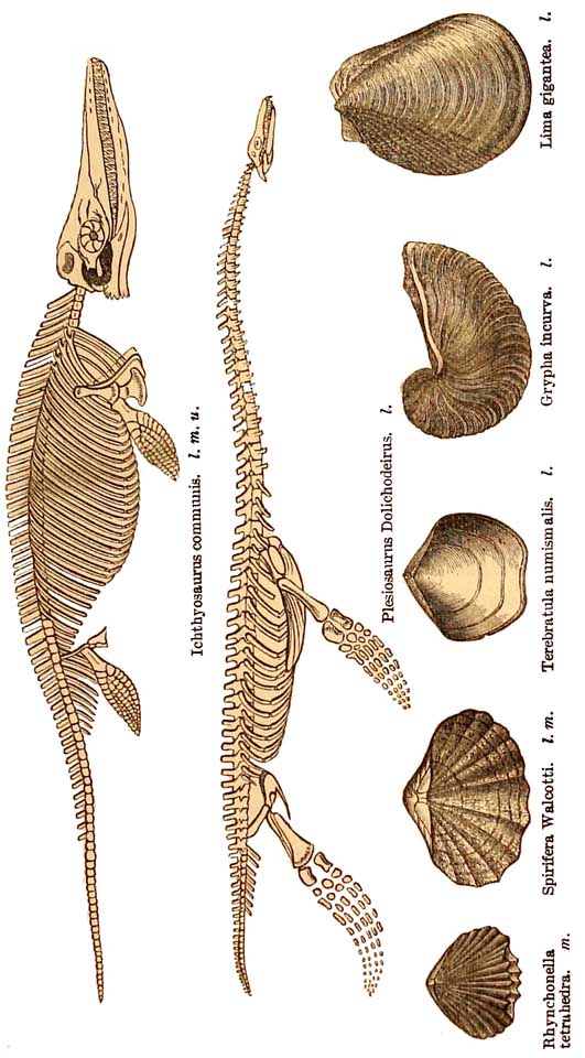
Group of Lias Fossils.
l. Lower. m. Middle. u. Upper.
[Upper Lias. 171]
exposed. In Yorkshire, however, on the sea-cliffs near Staithes, the stratigraphical relations of
the strata are perfectly clear, and it is evident that there is no line of demarcation between
them, and through about 15 feet of strata, including some of the well-known beds of ironstone,
fossils common to both occur, one of the most conspicuous of which is Pecten œquivalvis.
THE UPPER LIAS CLAY plays a comparatively unimportant part in the physical geology of
England. In Gloucestershire it first begins to appear near Bath, but so thin, that it is impossible
to represent it on maps of the 1-inch to a mile scale. About Wotton-under-Edge it begins to get
more definite, and from thence, in a narrow strip between the Maristone rock, and the sands
beneath the Inferior Oolite, it runs northward by Dursley, Stroud, Painswick, and Chipping
Camden, and following all the contours of the Oolitic escarpment, looks out upon the great plain
of Lias, in the broad valley of the Severn, or winds about among the intricate system of minor
valleys that lie between Minchin-Hampton and Chipping Camden, and between Burford and
Banbury. In this progress, gradually increasing in thickness, it forms great tracts of the clay
lands in Northamptonshire, between Great Brington and Arthington, and in the neighbourhood of
Uppingham and Oakham in Rutland, while further north, the clay runs in a long narrow strip,
still overlying the Maristone, into Yorkshire, where it is finely exposed in the seacliffs near
Whitby, and where in old times great excavations were made for the extraction of shale, and the
manufacture of alum.
Taken as a whole, the Upper Lias is a stiff dark blue clay, with occasional layers of limestone
often nodular, containing many Belemmites, Ammonites, and
[172 Lias and]
Nautili, and bivalve shells, similar, in general grouping of genera, to those of the Marlstone and
Lias clay, with both of which, but especially with the Marlstone, it has species in common. In
Yorkshire, the well-known jet of Whitby is excavated from the shales on the cliffs, and is
formed of the fossilised stems of coniferous trees that grew on the hilly islands, on the west and
north.
The remarkable assemblage of large Reptilia that inhabited the Liassic seas, the number of great
and small Cephalopoda, including many species of Ammonites, Nautili, and Belemnites, the
swarms of Terebratulæ and Rhynchonellæ, the plentiful genera and species of Lamellibranchiate
molluscs and of univalve shells, all speak of warm seas, surrounding islands, on which grew
Cycads, Zamias, and other plants, that seem to tell of a tropical or subtropical climate. Nor was
this phase of the physical geography of the time specially peculiar to the Lower Lias, for it
belongs alike to each of the divisions, and, as we shall by-and-by see, was continued into much
later times.
Nothing is more clear to me than this, that there was no break in time between the successive
conventional divisions of the Lower, Middle, and Upper Lias. Each in ascending succession lies
quite conformably on the other; between the Lower and Middle divisions there is a clear
lithological passage, accompanied by passage of species, and though there is generally a very
sudden break in lithological character between the Marlstone and the Upper Lias clay or shale
(due, perhaps, to rapid depression of the area), yet contrary to a not unprevalent belief, there
is a greater number of species common to these divisions than is generally imagined.
Out of 668 known species in the Lower Lias, 94,
[Passage of Species. 173]
or about 14 per cent. pass
into the Middle Lias; and of 500 species in the latter, 57, or about 11 1/2
per cent. pass into the Upper Lias ; while of 312 Upper Lias species, 39,
or about 12 1/2 per cent. pass into the Inferior Oolite which succeeds it.
Few biologists and geologists now believe in the sudden extinction of entire old marine faunas,
or even of the greater part of them, and their equally sudden replacement by new creations; for
it begins to be generally understood that life is variable and progressive, the change of species
in given areas being due chiefly, in comparatively short epochs, to migrations out of and into
these areas, in consequence of changes of local conditions, such as depth of water, and nature of
sediments, while in long periods of geological time, it is best accounted for by that process of
evolution so clearly expounded by Darwin. Neither is it a fair test of the community of species
in two so-called formations, to take the entire fauna of the lower one, and calculate the
percentage of forms that pass into the overlying deposit, for, between the lower and upper parts
of many thick formations, there is often the same kind of difference in assemblage of species
that there is between the adjoining parts of two so-called distinct formations. In judging then of
passage of species, if we had all the data, the fairest method would generally be to estimate the
passage of forms by those in common between the upper part of the lower formation and the
lower part of the upper one, in which case it would often be found, when there is a natural
conformity between the strata, that the percentage of species that pass onward is much
increased.
We now come to the Oolitic series of strata.
On the flank of the Cotswold escarpment, south of
[174 Passage of Species.]
Wotton-under-Edge, in Gloucestershire, the Tipper Lias clay is very poorly developed, and
between it and the ordinary limestone of the Inferior Oolite, there are thick beds of soft brown
sand, with intermittent hard, sandy, calcareous bands, containing Ammonites, Belemnites,
Pentacrinites, and bivalve shells. Above these there are bands of impure sandy limestone, called
in 1856, by Dr. Wright of Cheltenham, the Cephalopoda bed, because of the prevalence in it of
Ammonites, Belemnites, and Nautili, some of which, with other forms, are also common in the
Upper Lias clay. This fact induced him to consider these sands and impure limestone to be so
intimately related to the Upper Lias, that he named them in his Memoir 'the Upper Lias Sands'1 instead of ' the Mitford Sands (of the Inferior Oolite,') a name long before given to them by
William Smith.
According to existing lists, 17 species of Conchifera pass from the sands into the overlying
Oolite strata, and, indeed, about 39 or 40 species of all kinds are common to the Upper Lias and
the overlying Oolitic formations,2 thus linking the Lias to the Oolites in a continuous chain of
specific life.
Throughout the southern half of England, from the English Channel to the borders of
Northamptonshire, the various members of the Oolitic series maintain a tolerably uniform
character.
THE INFERIOR O0LITE LIMESTONE forms the lowest member of this series. It first appears
between the west end of the Chesil Bank and Bridport Harbour in Dorsetshire, from whence,
underlaid by the before-mentioned sands, broken and interrupted by many faults, it ranges
1 'Journal of the Geol. Soc.' 1856, p. 292.
2 As catalogued by Mr. Etheridge.
[Inferior Oolite. 175]
northward by Beaminster and Sherborne to the east end of the Mendip Hills and the
neighbourhood of Bath, where it forms the flat tops of the scarped hills intersected by so many
winding valleys. From thence, in a long narrow strip, it runs on by Wotton-under-edge,
Dursley, and Painswick, in Gloucestershire, near which, on the flat-topped Cotswold Hills east
of Cheltenham, it broadens, and more or less forms great part of the wide plateau that extends
from Burford to the neighbourhood of Chipping Camden. Beyond this region it narrows, and
finally thins away, and as a limestone disappears in Oxfordshire, a few miles northeast of
Chipping Norton, where I shall leave it for a time.
It chiefly consists of yellow limestone, and along with other limestones of the series is called
Oolitic, for in many cases they consist of concretionary bodies about the size of a pin's head,
compacted like the eggs that form the roe of a fish (egg-stone) cemented in a calcareous matrix.
One of the most typical sections occurs near Cheltenham, on the summit of the bold escarpment
that overlooks that town. There, at the base, the Oolitic grains are often as large as peas, and the
rock is locally called pea-grit.
The whole is apt to be fossiliferous, abounding in
Lamellibranchiate molluscs, Limas, Pectens, Oysters, Carcliums, Pholadomyas, Trigonias, and others needless here to name; and of Brachiopoda,
Terebratulas and Rhynchonellas are exceedingly numerous. Gasteropoda also occur in profusion,
including species of the genera Pleurotomaria, Natica, Littorina, Patella, &c. Belemnites,
Ammonites, and Nautili are found in profusion, together with genera and species of sea-urchins,
such as Cidaris, Pseudo-diadema, Pygaster, &c.
[176 Fuller's Earth.]
Plants are rare in the purely marine strata of Gloucestershire and the south of England, but
fragments of coniferous trees are sometimes found, the most remarkable of which is a large
cone of Araucarites hemisphœricus. This, in addition to the nature and multiplicity of genera
and species of the marine fauna, plainly tells of land not far off, a fact that will become still
more clear as we get further on with the history of the Oolites, and its bearing on the old
physical geography of the land of the Oolitic epoch.
THE FULLER'S EARTH accompanies and overlies the Inferior Oolite through the whole length of
this area, excepting where locally interrupted by faults. It consists chiefly of tenacious bluish clay, with frequent thin shelly bands of limestone, often largely
charged with a small oyster, Ostrea acuminata, and with Terebratulæ. In the neighbourhood
and south of Bath a strong band of limestone lies in the middle of the clay, known as the Fuller's
Earth Rock.
Near Upper Slaughter in Oxfordshire, this subformation entirely thins away, and is known no
more. Its greatest thickness, near Bath, is about 200 feet. The name was originally given to it
by William Smith, because in places it contains beds of Fuller's Earth, long ago much used in
the famous woollen factories of Gloucestershire. I call it a subformation, because very many of
its fossils are also common in the Inferior Oolite, though a few are peculiar.
THE GREAT or BATH OOLITE of this southern half of England succeeds the Fuller's Earth, and
consists, when fully developed, of
Forest Marble.
Great Oolite.
Stonesfield Slate.
[Stonesfield Slate. 177]
The local development called the Stonesfield Slate
consists of beds of laminated shelly and oolitic limestone and sandy flags, with much false
bedding, and containing ferns, Cyclopteris, Glossopteris, Pecopteris, &c.; Cycads, Bucklandia
squamosa, Zamias, Palœozamia of various species, and Coniferæ. Elytra of beetles and wings of
insects (Libellula Westwoodii, &c.); bones of Plesiosaurus, Crocodile, &c.; also Ostrea,
Terebratula, Rhynchonella, Lima, Pecten, Trigonia,
Patella, Nerinœa, Belemnites, Ammonites, &c., are
all found in these thin shallow water deposits. The reptiles include Ichthyosaurus advena,
Plesiosaurus erraticus, and crocodiles of the genus Teleosaurus,
allied to the Gavial of the Ganges (T. brevidens
and T. subulidens), together with a great carnivorous lizard, Megalosaurus Bucklandi, that
walked on the neighbouring land, and was probably about 30 feet in length. A flying reptile,
Ramphorhynchus Bucklandi, allied to the Pterodactyle, is found in this subformation, which
has long been especially celebrated as containing the remains of mammals, viz. the lower
jawbones of species of small insectivorous marsupials, Amphitheriurn Broderipii, A.
Prevostii, Phascolotherium Bucklandi, and Stereognathus Ooliticus.
I call the Stonesfield Slate a local development because it is by no means of universal occurrence
at the base of the Great Oolite, and is chiefly known in those parts of Gloucestershire that lie
eastward of Cheltenham on the broad Oolitic plateau, and in Oxfordshire at and near the town of
Stonesfield, where it perhaps attains its greatest thickness. There it is largely manufactured
into what are called slates, but in reality are small slabs, the coarse fissile character of which
has no relation to what is known as slaty cleavage. From these areas
[178 Great Oolite.]
going south along the Oolites, the Stonesfield Slate rapidly thins away, or changes its lithological
character, for it is quite unknown at the base of the Great Oohte towards Wotton-under-Edge and
Bath. In the opposite direction going northward, the Stonesfield Slate passes into the
Northampton Sand, where we will leave it for the present.
The Great Oolite was originally so called by William Smith in 1812, and the Upper Oolite in
1815, to distinguish it from the Lower or Inferior Oolite, which lies below the Fuller's Earth,
whereas the former lies above it. It is often named the Bath Oolite, and the greatest development
of that excellent building-stone is near the city, which is almost entirely built of 'Bath stone.'
It first makes its appearance on the south near Norton St. Philip, about six miles south of Bath,
from whence, overlaid by Forest Marble, it ranges northerly, forming the flat-topped scarped
hills on either side of the Avon near Bath, and so on by Wotton-under-edge to MinchinHampton.
Beyond this it forms a large part of the table land, intersected by valleys, that lie between
Minchin-Hampton in Gloucestershire and Towcester in Northamptonshire. In Northamptonshire
its lowest sandy beds are the equivalents of the Stonesfield Slate, To this part of the subject I
shall return in describing important physical changes that take place further north.
The best beds of the Great Oolite are of cream-coloured limestone, so soft when first extracted
from the quarry, that it can be easily sawed into blocks, but hardening on exposure. Some of its
fossils are also found in the Fuller's Earth and the Inferior Oolite, and a few are first known in
the Lias, and, indeed, throughout the whole there is a general agreement in the
[Lower Oolitic Fossils. 179]
FIG. 37.
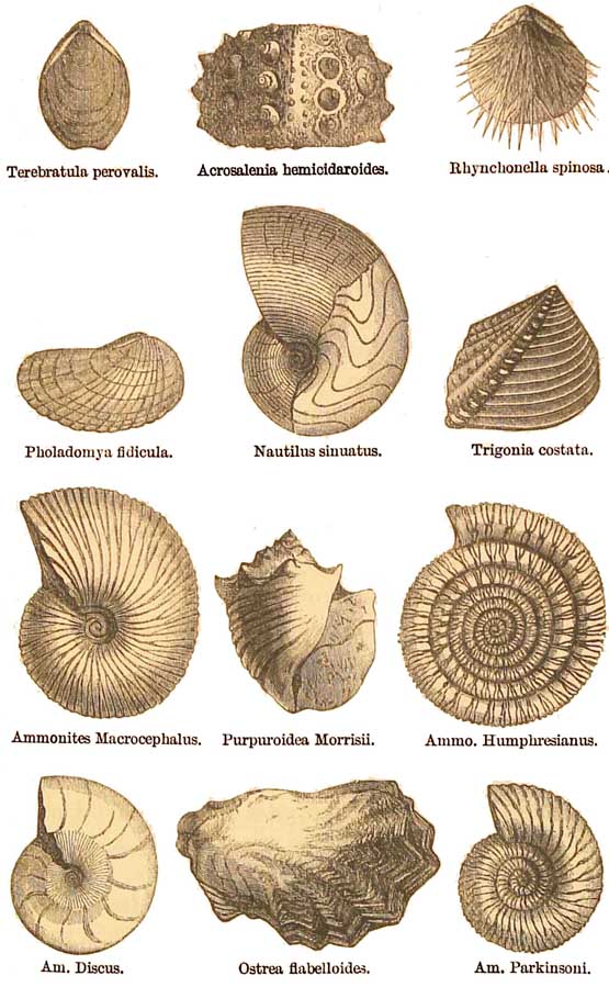
Group of Fossils of the Lower Oolitic Formations.
[180 Forest Marble.]
genera of shells. Corals occur in the Great Oolite, including more than twenty species, chiefly
belonging to the genera Stylina, Isastrea, Thamnastrea, &c., and Brachiopoda of the usual
genera Rhynchonella (Rh. concinna, &c.), and Terebratula (T. digona, T. obovata, &c.),
besides great numbers of Lamellibranchiata, the most numerous of which belong to the genera
Ostrea (O. Sowerbii, &c.), Pecten (P. vagans, &c.), Gervillia (G. monotis, &c.), Lima (L.
cardiiformis, &c.), Mytilus (M. imbricatus, &c), Trigonia (impressa, &c.), Cardium,
Astarte, Ceromya concentrica, &c. Pholadomya socialis, &c., Cyprina, Pecten, Lima, and
many others. Near Minchin-Hampton it is rich in Gasteropoda, among the most common of
which are many of the genera Patella,
Pleurotomaria, Trochotoma, Purpuroidea (P. Morrisii), Natica, Chemnitzia,
Nerinea, Alaria, Ceritella, Cylindrites, Turbo, and many others.
Ammonites and Belemnites are rare at Minchin-Hampton, but further south Gasteropoda
decline, and Cephalopoda are more numerous. Echinodermata of the genera Acrosalenia,
Clypeus, Echinobrissus, and others are not uncommon, and Pentacrinite joints occur rarely.
Fishes' teeth, Hybodus, Pycnodus, and Strophodus, and scales of Lepidosteus are sometimes
found, and reptiles of the genera Teleosaurus and Megalosaurus, together with the gigantic Ceteosaurus (or whale-lizard), probably about 50 feet in length, and most likely amphibious.
The Forest Marble forms the topmost beds of the strata that usually are called Great Oolite. They
are formed of shelly limestone, with much false bedding, very similar in stnicture to the
Stonesfield Slate, and as a marble the rock has sometimes been used for ornamental purposes.
Its beds are full of Oysters, stems of
[Cornbrash. 181]
Pentacrinites, fragments of Echinodermata, Pectens, Aviculœ, Terebratulœ, &c. In it occurs
the Bradford clay, in which is found the beautiful Crinoid, Apiocrinites rotundus, and also
Terebratula digona, and many fragments of Coniferous wood.
On the south coast the Forest Marble borders the sea for a considerable distance between
Bridport Harbour and Portland Isle, from whence it ranges north by Wincanton to Frome in
Somersetshire. A few miles further north, the Great Oolite proper crops from underneath it
near Norton St. Philip, and beyond this town and Bath it everywhere overlies the Great Oolite,
and forms the surface of vast tracts of country between the Avon, Cirencester, and Burford, in
Gloucestershire, beyond which, towards Witney, on the river Windrush, it gets broken into
outliers, and also becoming thinner, it either dies out, or is gently overlapped by the Cornbrash
about three miles north of Bicester in Oxfordshire.
The CORNBRASH forms the uppermost member of those formations that are usually classed as
Lower Oolite. It is generally of inconsiderable thickness (15 to 100 feet), and beginning in
Dorsetshire between Bridport and Weymouth, it ranges at the surface all across that county,
excepting where overlapped by the Cretaceous strata between Abbotsbury and the neighbourhood
of Evershot. It is remarkably constant, striking with the underlying and overlying strata all
through Wiltshire, Gloucestershire, Oxfordshire, and Northamptonshire, and onward into
Lincolnshire; but north of the Humber it disappears for a space, being again overlapped by
unconformable Cretaceous strata.
Throughout all this long range it retains in a
[182 Passage of Species.]
remarkable manner the same lithological character, showing evidence of deposition in shallow
water. It is partly formed of pale many limestones and clays, passing in places into shelly, and
occasionally oolitic, building-stones. When partly decomposed near the surface, it assumes a
rubbly character, and forms a fertile soil, whence its agricultural name of Cornbrash, the word
brash being an old word expressive of this loose rubbly character.
The Cornbrash is generally very fossiliferous, the general assemblage of genera of
Echinoderms, corals, Cephalopoda, Brachiopoda, Lamellibranchiata, &c. being much the same as
in the Great and Inferior Oolites. So much, indeed, is this the case, that of the forms found in the
Great Oolite, 100 species pass into the Cornbrash, while of those in the Inferior Oolite, 89
species pass up into the same formation.
This community of forms is very important, showing as it does, that if some of the Inferior
Oolite species are absent in the Fuller's Earth and Great Oolite, they must, nevertheless, during
the deposition of these strata, nave lived elsewhere, and returned in a later time, that of the
Cornbrash, to inhabit the same area when a congenial set of marine conditions ensued, thus
establishing a strong and direct succession of life through the whole of these formations which
together, in the language of the day, form the Lower Oolite. In fact, this division of these strata
into formations, is in great part lithological, and the difference of faunas in them was
dependent on changes of conditions of depth &c. in a sea, where limestone, sands, or clays were
being deposited. The four so-called Oolitic formations already described, may in truth be spoken
of as one, there being not much more difference between their fossils.
[Middle Oolites, Oxford Clay. 183]
than there is between those of what are called different zones in other recognised single
formations.
Facts of this broad kind are of more importance to the general reader than trying to remember
names of fossils, and what I now endeavour to do, is to disabuse the mind of the idea, too often
implied in manuals, that the marked characteristic of strata is, that they consist of perfectly
distinct zones, each having its own species, which have little connection with each other. What
applies to the Lias and Lower Oolites, equally applies to the connection of the latter with the
Middle, and of the Middle with the Upper Oolites, and I shall therefore treat the remainder of
this subject as briefly as possible.
The next group of strata, as generally received, is formed of the Middle Oolites, which consist of
the following divisions, the oldest being placed at the bottom:—
Coral Rag and Calcareous Grit.
Oxford Clay:
Clay
Kelloway Rock.
Clay; a thin band.
In the south of England, much faulted, the OXFORD
CLAY occupies considerable strips of country between Weymouth Bay and the river Bredy, about
a mile east of Burton Bradstock. Beyond that faulted region, and the overlapping of the
Cretaceous strata of Dorsetshire, the Oxford Clay, about 650 feet in thickness, comes on in
great force at Melbury Samplord and Melbury Osmund, where it is underlaid by about 50 feet of
Cornbrash. From thence it runs somewhat north-easterly, covering a broad tract of country, by
Melksham in Wiltshire, and so on by Chippenham, Cricklade, Fairford, Bampton, Oxford,
Bicester, Buckingham, Fenny Stratford
[184 Kelloway Rock.]
and Bedford, north of which it covers an immense tract of country, twenty miles in width, in
the neighbourhood
of Huntingdon. Still further north it underlies the great alluvial flats of Cambridgeshire, and
the waters of
the Wash, and beyond this, in Lincolnshire, in consequence of the gradual overlap of the Cretaceous strata, the area occupied by the Oxford Clay
narrows by degrees. North of the Humber it is entirely overlapped for a space, to reappear in
Yorkshire, where it is well exposed on the sea-cliffs in Filey Bay, accompanied by the Kelloway
Rock.
Not the least remarkable circumstance connected with the Oxford Clay is the very frequent
occurrence in it of this Kelloway Rock, which some persons would willingly raise to the rank of
an independent formation, because of its palæontological peculiarities. The thin clay that
occasionally lies beneath it contains a goodly proportion of species also found in the Cornbrash,
but a greater number found in higher parts of the Oxford Clay. When analysed it appears that
the Calcareous sandstone, called the Kelloway Rock by Smith,1 contains not less than about 150
species, of which very nearly one-half are also found in older formations, thus forming a close
bond of union between them. An equal number passes upward from the Kelloway Rock into the
overlying Oxford Clay, or, if absent there, are found in formations still higher in the series.
The Kelloway Rock contains many Gryphœas and Ammonites, one of which, A. Calloviensis, is
especially characteristic of this stratum. Several other Ammonites, and Ancyloceras Calloviense, besides Nautili (N. hexagonus), &c., are found in it.
1
I believe originally 'Kelloway's Rock,' named from Kelloway, who quarried it.
[Coral Rag. 185]
Brachiopoda and Lamellibranchiata, of genera and some species common to all the Oolites, are
common. The Oxford Clay also contains many Belemnites, Ammonites, and other shells, among
which, Ammonites Jason, Ostrea flabelloides, and Gryphœa dilatata are characteristic of this
formation. Trigonia costata, an inferior Oolite species, passes upwards thus far. The general
assemblage of fossils in the Oxford Clay and Kelloway Rock generically, and largely in species,
strongly resembles that of the Lower Oolite formations, but the life is not so numerous. Fishes,
Hybodus, Lepidotus, and Pycnodus are found, and Reptilia of the genera Dakosaurus,
Ichthyosaurus (I. dilatatus and thyreospondylus), Megalosaurus Bucklandi, Pieiosaurus
gamma and P. grandis, 4 species of Plesiosaurus, P. Oxoniensis, &c., Rhamphorhynchus
Bucklandi, Steneosaurus, and Streptospondylus Cuvieri.
The plentiful assemblage of fossils in an accidental stratum so thin as the Kelloway Rock, lying
in the Oxford Clay, speaks of physical conditions in the sea favourable to the development of life,
and the diminution of species in the thick beds of the Oxford Clay seems to tell of the deepening
of a sea in which much muddy sediment was being deposited.
The CORAL RAG is a rubbly limestone, trending, with occasional interruptions, from
Somersetshire to Yorkshire, the details of which it is unnecessary to give. It is associated in
places with sandy strata known as the Calcareous grits, and is often almost entirely composed of
broken shells and Echini, Cidaris Smithii, Hemicidaris intermedia, Pygaster umbrella,
Pygurus costatus, &c., and numerous corals (whence its name) of the genera Isastrea,
Thecosmilia, Protoseris, &c.,
[186 Upper Oolites.]
Ammonites, a few Gasteropoda, and various genera of
bivalves, common in the Oolitic formations.
This formation is rarely more than about 300 feet thick, and about one-third of its fossils are
well known in older Oolitic strata, while less than a tenth pass
FIG. 38.
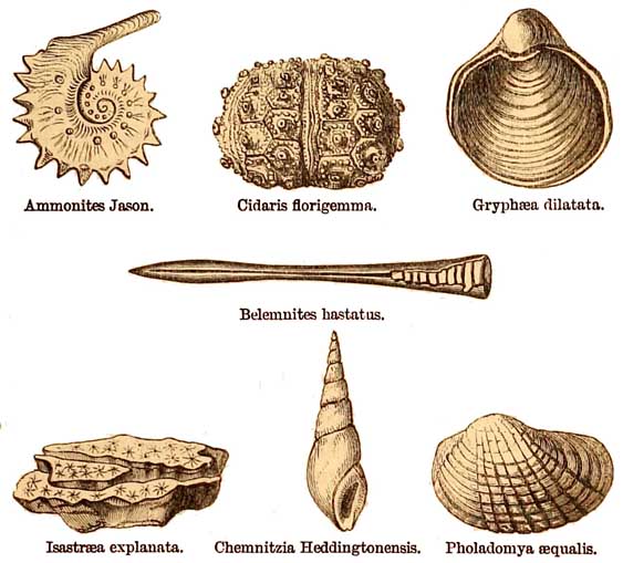
Group of Fossils in the Middle Oolites.
upward into the overlying Kimeridge Clay and Portland rocks.
For reasons connected with the physical geography of this epoch, which will be mentioned
further on, I confine the Upper Oolite to two formations, viz.:
Portland Limestone and Sand,
Kimeridge Clay.
The stratigraphical arrangement of these strata and
[Kimeridge Clay. 187]
of the overlying Purbeck Limestone is well seen in the Isle of Portland, where all the strata dip
gently from north to south, as shown in the annexed diagram.
FIG. 39.
Section of the Oolite and Purbeck strata, Isle orf Portland.

The KIMERIDGE CLAY takes its name from Kimeridge Bay in Dorsetshire, on the cliffs of which
it is well exposed, with bands of cement stones and many fossils,
such as Ammonites, Belemnites,
Reptilian bones, and many ordinary molluscous shells. Certain hard, shaley bands at Little
Kimeridge have been at intervals
used for the manufacture of naphtha and mineral oils, but, I
think, never with great success. West of this area the clay is well known in the northern half of
Portland Isle, in Portland Road, and in the country near the chalk hills, between Ringstead Bay
and Abbotsbury. North of this it is overlapped by the Cretaceous rocks between Abbotsbury and
Buckland Newton near Cerne Abbas, from whence, beginning in a narrow band, it gradually widens, trending north along the borders of the Cretaceous
escarpment between Shaftesbury and Mere. West of Mere it occurs in interrupted patches at the
foot of
[188 Kimeridge Clay.]
this great escarpment as far north as Rowde, near Devizes, where it is again overlapped by the
unconformable Cretaceous strata, to reappear at Calne, from whence, on the north-east, it
comes on in great force, covering a broad tract of country by Swindon and Longcott. A little east
of Longcott, a great tongue of Lower Greensand, running out to Farringdon, overlaps the
Kimeridge Clay. Escaping from this overlap, the clay runs eastward by Abingdon, Netley,
Quainton, and the south end of Stewkley, between which and Leighton Buzzard it is again
overlapped by broad-spreading strata of Gault and Lower Greensand. Between this area and the
fens of Lincolnshire it doubtless lies deep underground, well to the east of the Chalk
escarpment, for it is well known to underlie much of the marshes on either side of the Wash,
from whence it trends north in a strip at the base of the Lincolnshire Wolds as far as the
Humber, where it is again unconformably overlapped by the Cretaceous strata of the Yorkshire
Wolds, to reappear in great force in and around the Vale of Pickering, between Hambleton Hills
and Filey Bay in Yorkshire.
The Kimeridge Clay is in places from 500 to 600 feet in thickness, but of late, in a great
experimental boring in the Weald of Kent, after passing through the Purbeck and Portland
Limestones and Sand, it was pierced to the depth of 921 feet, below which came clays supposed
to be the Coral Rag and Oxford Clay, the base of which was not reached at 1,906 feet when for
financial reasons the boring was abandoned. The meaning of this seems to be, that whereas these
clays, in their range from Dorsetshire to Yorkshire, were deposited in comparatively shallow
areas not very far from land, in the Kent area they were laid down in a much deeper sea.
[Upper Oolite Fossils. 189]
FIG. 40.
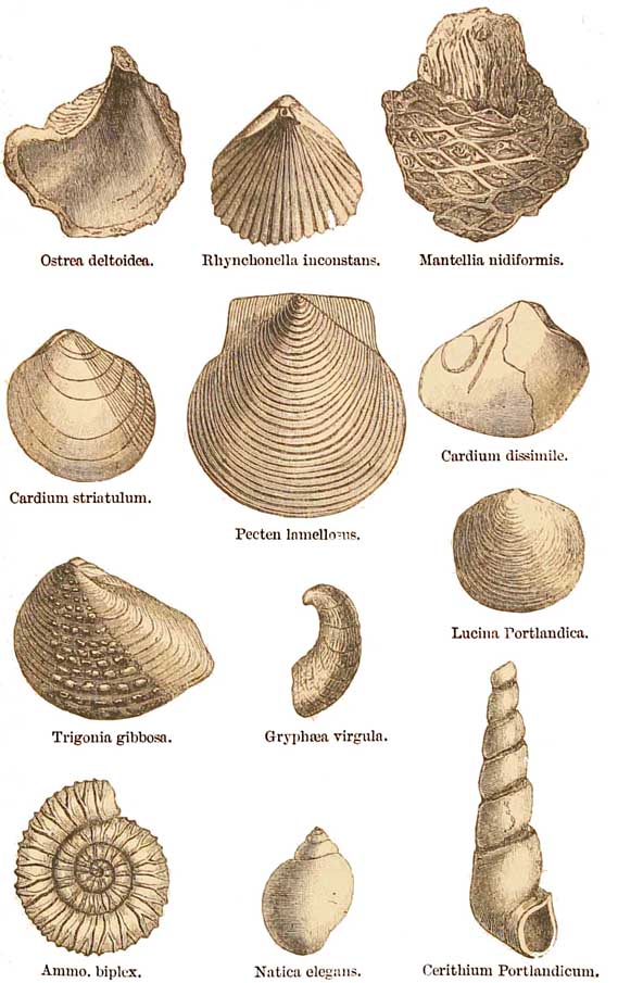
Group of Kimeridge Clay and Portland
Fossils. Upper Oolite.
[190 Portland Beds.]
A shell peculiarly characteristic of the Kimeridge Clay is a large oyster, Ostrea deltoidea, Fig.
40. Shells of the genera Rhynchonella (Rh. incontstans) and Terebratula, Discina (D.
Humphresiana, &c.), Lingula ovalis, Pinna, Astarte, Pecten, Trigonia (T. incurva), and other
bivalves, and Ammonites and Belemnites, are also common, the Belemnites sometimes almost
paving the ledges of the seashore in Kimeridge Bay. Fishes of the Oolitic genera already named,
with others, are found, and many remains of reptiles, among others Turtles, Crocodiles of the
genera Goniopholis, Teleosaurus and Steneosaurus, 5 species of Ichthyosaurus, 8 of
Plesiosaurus, and 5 of Pleiosaurus, some of the last of great size. Cetiosaurus longus and
Megalosaurus Bucklandi also occur. Fragments of wood are not uncommon.
The PORTLAND LIMESTONE and SAND lie above the Kimeridge Clay. The best sections of these
rocks occur in the Isle of Portland, as shown in fig. 39, p. 187. The sand which forms the base
of the formation, is there 150 feet thick, and the limestone about 70. Of this, about 20 feet
forms marketable stone in three horizons, from the best part of which the celebrated Portland
stone is derived, used in many public buildings, of which St. Paul's may be cited as an example.
The limestone, like those of most other Oolite formations, is cream-coloured, and generally
fossiliferous. Among the most common forms found in it are Trigonia gibbosa and T. incurva,
Pecten lamellosus, Ostrea expartsa, Cardium dissimile, Terebra Portlandica, and various
Ammonites, some of them of large size. The lowest beds are full of layers of flint and chert. The
sand is fossiliferous, containing Oysters, Carcliums, &c. The Portland stone also occurs
[Northampton Oolites. 191]
at the south end of the Isle of Purbeck, in the Vale of Tisbury in Wiltshire, at Swindon, and in
the Vale of Aylesbury. The beds are very inconstant in their outcrop, only showing at those
places which were probably near the original western margin of the sea of the period. At
Swindon both limestone and sand are of trifling thickness. Outliers of it occur in Bedfordshire,
and the whole has evidently been exposed to denudation before the deposition of the Cretaceous
rocks.
Such is a brief outline of the marine Oolitic strata in the south and centre of England, and also of
the Upper and Middle Oolites in their range into Yorkshire.
It will be observed that in this description I have specially insisted on the unconformable
overlapping of the Cretaceous strata across the Portland, Kimeridge, and other formations, at
intervals, all the way from Dorsetshire to Yorkshire, for by-and-by it will appear that this
fact has an important bearing on the physical theory of the deposition of the Purbeck and
Wealden strata, which come next in succession.
In the meanwhile, I must return to the Northamptonshire area, where we left the Lower Oolites,
and follow them into Yorkshire, when it will be seen, that they were formed under physical
conditions in some respects very different from those which obtained in the South, while the
marine clays and limestones of the Lower Oolites of that area were being deposited.
It will be remembered that in Gloucestershire, a few miles west of Stow-on-the-Wold, the
Fuller's Earth thins out, and the Inferior Oolite and Stonesfield Slate come together, the latter
being formed in part of the sandy flags that make the base of the Great Oolite, and constitute the
Stonesfield Slate. Going easterly into
[192 Northamptonshire and Lincolnshire.]
Oxfordshire, these beds get still more sandy, the limestone of the Inferior Oolite disappears by
degrees, sandy beds replace them, which are overlaid directly by the sands of the Great Oolite,
the two forming together what are generally known as the Northampton Sands. By-and-by, in
the district of Rockingham near Geddington, the Inferior Oolite Limestone begins to reappear,
overlying the lower part of the Northampton Sands, and lying flat, and thickening by degrees, it
forms the surface of a great tract of country towards Stamford and Thistleton, in
Northamptonshire and Rutlandshire, also towards Grantham, and in Lincolnshire, being always
underlaid by the Northamptonshire Sand. The Inferior Oolite of this district is well known as
the Lincolnshire Oolite Limestone. The sands beneath it have been largely worked in
Northamptonshire for ironstone, and their upper part is occasionally white, 'with remains of
plants, sometimes vertical, also thin seams of lignite, and miniature underclays,' while 'thin
seams containing Cyrena (a fresh-water bivalve shell) occur in this part of the series. These
beds have been distinguished by Mr. Judd as the Lower Estuarine Series.1
Above the Lincolnshire Oolite Limestone there lie
certain strata, named by Mr. Judd the Upper Estuarine Series, forming, in his opinion, the lowest part of the Great Oolite of this area. They are
well seen in some of the cuttings of the Great Northern Railway, and on the top of the Inferior
Oolite Limestone quarries at Ketton, Clipsham, and Casterton. As described by Mr. Judd, there
are in these strata 'bands of sandy stone with vertical plant markings and layers of shells,
1
'Geology of Rutland,' &c. J. W. Judd, p. 92, 'Memoirs of the Geological Survey.'
[Physical Geography. 193]
sometimes marine, as Pholadomya, Modiola, Ostrea, Neœra, &c.; at other times fresh-water
shells, as Cyrena, Unio,' &c., and he correctly states that 'all the characters presented by the
beds of the Upper Estuarine Series, point to the conclusion that they were accumulated under an
alternation of marine and fresh-water conditions, such as lakes place in the estuaries of
rivers.' These strata between Northampton and Grantham are rarely more than about 25 feet in
thickness.
When we think of the meaning of these phenomena, it is evident that, while from
Gloucestershire to the south coast, all the strata from the base of the Lower lias to the top of the
Oolitic series are marine, in the middle area of Northamptonshire, Rutland, and Lincolnshire, a
set of conditions prevailed in the time of the deposition of the Lower Oolites that indicated filling
up of the area, and temporary elevation of the old marine deposits, in places, quite above the
level of the sea, so that swampy terrestrial surfaces were formed, through which wandered
minor streams inhabited by fresh-water shells. Further north this fact becomes still more
plain.
After crossing the Humber, and passing the unconformable overlap of the Cretaceous rocks of
the Yorkshire Wolds, a series of Liassic and Oolitic strata appears in the North Riding, forming
a great tract of beautiful hilly country, the sections of which are best seen on the coast cliffs
that lie between the mouth of the Tees and Filey Bay. That part of the cliffs of which the strata
are of Oolitic age, more or less includes representatives in time of all the so-called formations
from the Inferior Oolite to the Kimeridge Clay inclusive. The lithological characters, and mode
of formation, of all the strata that are presumed to lie between the horizon of the base of the
inferior Oolite and the Cornhrash, are, however, of a
[194 Yorkshire Oolites.]
very different nature from those of the equivalent strata in the south of England, and though I
have examined these sections from end to end, I shall quote from the measured sections of Mr.
Etheridge, and give the latest information.
Resting directly on the Alum shales of the Upper Lias, there are sands intermingled with bands
of shale, the whole being about 50 feet thick. All the fossils, which are generally scarce, are of
marine species, and the whole of the strata are known to palæontologists as the zone of Ammonites
Jurensis, and it is generally considered to be the equivalent of the Midford Sands of the South of
England, or the Sands of the Inferior Oolite, as named by William Smith.
Above these come strata, locally known as Dogger, consisting of about 30 feet of brown sands,
which are sometimes ferruginous and red. They are interstratified with shaley sands, and the
whole contains numbers of the marine fossils of the Inferior Oolite.
On these there lie about 200 feet of sandstone, destitute as far as known of the remains of any
kind of life, except a few land plants. Then comes about 25 feet of sandy limestone, known as the
Millepore Bed, full of fossils common in the Inferior Oolite of the south. This is succeeded by
about 80 feet of shales interstratified with sandstones, as yet destitute of the remains of
molluscs, but what is of especial interest, there are at least eight distinct bands of coal,
interstratified chiefly with the shales, and several other lines of carbonaceous matter more
interrupted and broken. What adds to the importance of this fact is, that the coal-beds have not
been formed of drifted vegetation, for underneath each bed there occurs an underclay or
[Yorkshire Oolites. 195]
old soil, charged with the roots of those plants, the decay of which on the spot formed the thin
beds of coal, just in the manner that coal-beds were formed during t.he Coal-measure epoch,
but, in the case of these Oolitic coal-beds, on a much smaller scale.
Above these fresh-water and terrestrial strata, there occur beds of 'grey limestone' and shales.
It is often called the Scarborough Limestone, and is full of marine shells, &c., common in the
ordinary Inferior Oolite. Finally, on the top of this, there are strata of sandstones and shales,
often called the upper series, to distinguish them from the lower sandstones and shales that lie
below the grey marine limestone. Like the lower series, they seem to contain no mollusca of any
kind, and, indeed, the only fossils that have been found in them are the remains of plants
scattered through the rocks, accompanied here and there by streaks of coaly matter. On the
whole, such evidence as there is, tends to show that these also are fresh-water or at most
estuarine strata.
Overlying these sands, there is a persistent band of impure limestone, generally from 3 to 6
feet thick, which is considered to represent the Cornbrash of more southern areas, where, it
will be remembered, it lies directly on strata of the Great Oolite series. It is certain that in its
fossils it is intimately related both to the Great and the Inferior Oolite, including the Fuller's
Earth. If, therefore, we take the Lower Oolites as a whole, the most philosophical method of
regarding them is to consider them as one. Owing to minor changes in the physical geography of
the sea bottom, and of the neighbouring land, this formation was, during the progress of
deposition, locally broken up into a series of subformations, now of limestone, now of clay, now
of
[196 Physical Geography.]
sand, and, according
to locality, of marine, estuarine, fresh-water, and even terrestrial origin;
marine in Dorset, Somerset, and Gloucestershire, partly passing into
estuarine and fresh-water strata in Northamptonshire, at the very time, for example,
that the marine sediments of the Stonesfield Slate, had washed in among them,
from the neighbouring land, plants, insects, and marsupial mammals. Still
further north, in Yorkshire, the equivalent of great part of the Inferior
Oolite actually constitutes a coalfield, on a miniature scale, quite comparable,
in its sandstones, shales, underclays, and beds of coal, to the broad and
thick deposits of the Coal-measures, and showing the same kind of alternations
of terrestrial and aquatic conditions, indicating, repeated filling by sediments
of a certain area, its conversion into land, and its subsequent depression
to receive new accessions of sands and shales.
These circumstances seem to me to agree, in a striking manner, with what may be surmised to
have been the state of the geography of the neighbouring lands. In the south of what is now
England the seas were broad and comparatively shallow, during all the time of the deposition of
the Lower Oolites, and the islands round which these seas flowed (including Wales) were
comparatively small. But further north we come to a fragment of a much larger land, formed of
Palæozoic rocks, that in those days formed a mountainous country extending from the hills of
Derbyshire far away to the northern extremity of Scotland, and how much further entire, or
broken into islands, no man yet knows. In spite of disturbances of upheaval of later date than
these Oolitic times, it may also very well have been that this old land was much higher than the
highest Highland mountains of the present day, seeing the vast
[Physical Geography. 197]
amount of waste and degradation that they have undergone since that ancient time, and we may be
sure that it was surrounded by seas of this lower Mesozoic epoch, for fragments of the Oolitic
strata still surround the island. This was the larger land, from which the rivers flowed that
deposited the fresh-water sands described above. On the low banks of these rivers grew many a
plant now represented merely by indistinct impressions—
'Their meaning lost,
Save what remains on stone, or fragments vast'—
in which the relics of species of Araucaria, Cycas, Zamia, Screw Pine, and numerous other
forms, together with gigantic Equisetums which grew in the still waters on their borders, while
Marsupial mammals on the shores, and Trigoniæ and Terebratulæ in the seas, help us to realise
that the physical characteristics of the time in some degree resembled that of Australia in our
own day, a circumstance first noticed by Professor Owen.
This state of affairs was at length partly brought to an end by a gradual submergence, during
which the Oxford and Kimeridge Clays were deposited in open seas, but the sinking of the area
was not by any means so great as to swallow up the old islands round which the strata were
formed, and which still remain, much changed, as the most lofty portions of Great Britain. Such
fragments of the Jurassic strata as still remain on the coasts of Scotland throw some light on
this question.
On the east of Scotland, at and near Brora, in Sutherland, the Liassic and Oolitic strata have been
long known, and were first described in the Journal of the Geological Society in 1858 by Mr.
(afterwards)
[198 Lias and Oolites of Scotland.]
Sir R. Murchison. In 1859 I
accompanied him during a tour in Scotland to that district, and mapped the
strata with all its faults and dislocations, but never published the results.
The region was afterwards investigated by Mr. Judd, and the results published
in great detail in the 'Journal of the Geological Society,' for 1873. At
the base lie Keuper sandstones, &c., with Stagenolepis (a crocodile)
and Telerpeton (a land lizard), &c., above which are beds of sandstone
and conglomerate, which may possibly represent the Rhætic beds. These are
succeeded by about 400 feet of sandstone and shale, with plant remains and
seams of coal (terrestrial), with pectens in the overlying strata. These
are overlaid by limestones and beds of blue micaceous clay, both full of
Lias fossils; the whole is well seen on the shore near Dunrobin. Of later
date, in the same district, the Lower Oolite consists partly of marine and
partly of freshwater strata, with Oysters, Perna, Unio, Cyrena, Cypris,
&c., and land-plants and coal seams, one of which is 3 feet thick, and
has been worked. The Middle Oolites of the district are considered by Mr.
Judd to represent the whole of the English strata from the base of the Oxford
Clay to the Coral Rag inclusive. They are full of marine shells of the usual
genera and species, and occasionally contain plants and bands of lignite.
The whole series is perhaps nearly 1,000 feet thick, and consists to a great
extent of sandstones, with occasional limestones, conglomerates, and shales.
The Upper Oolite, which is supposed to represent the lower part of the Kimeridge
Clay, and all the higher beds, are marine, with occasional remains of land
plants.
As a whole, the Liassic and Oolitic series of Brora dip east and north-east along the shore
between Dunrobin and Helmsdale, the older parts of the series being
[Lias and Oolites of Scolland. 199]
at Dunrobin, and the younger at and near Helmsdale A great fault, nearly 20 miles in length,
runs along the shore, and throws the secondary strata down against the older Paleozoic rocks on
the north-west. Interstratifled with the black shales near Helmsdale, there are occasional beds
of brecciated conglomerate. The shales contain thin layers of plants and many broken shells, and
the breccias contain angular and subangular blocks, chiefly of Old Red Sandstone, with a
mixture of the older rocks of the Highlands, sometimes 6 or 8 feet in diameter, in fact, boulder
beds, which long ago suggested to me the action of floating ice. Mr. Judd suggests that they may
be due to river ice, floated on streams flowing from the west, at a time when the larger part of
the gneiss of the Highlands was covered by Old Red Sandstone, since denuded.
In the Inner Hebrides, the Lias, Inferior Oolite, Middle Oolite and Oxford Clay occur in the
Island of Skye. The Lias, as described by Geikie, consists of beds of limestone, sandstone,
conglomerate, and shale. It contains the usual fossils. The rocks are much disturbed, and the
limestones have been metamorphosed into crystalline marble accompanied by the intrusion of
syenite. The section at Loch Staffin, given by Edward Forbes, is as follows:
Oxford Clay. Inferior Oolite.
Estuary Shales. Lias.
Middle Oolite.
Between the Middle Oolite and estuary shales, a bed of columnar basalt is intercalated, and the
whole is overlaid by amygdaloidal trap, which breaks through and overspreads the strata. These
igneous rocks are intrusive and of Miocene age. The estuary shales contain Oysters, Unios,
Cyrenas, Paludinas, &c., distinct
[200 Lias and Oolites of Scotland.]
from those of Brora and of the English Purbeck strata. In Mull, Lias and Oolites occur, ranging
from the Lower Lias to the Upper Oolitic series, overlaid by Lower Cretaceous strata. They are
traversed by many dykes and intrusive sheets of basalt, formerly considered as of Oolitic age,
but now, as described by Professor Geikie, of Miocene date.