CHAPTER XVIII.
THE PHYSICAL STRUCTURE OF SCOTLAND—THE HIGHLANDS —THE GREAT VALLEYS OF THE FORTH
AND CLYDE—THE LAMMERMUIR, MOORFOOT, AND CARRICK HILLS.
I NOW come to that part of the subject in which it will be my duty to explain the connection
between the geological phenomena of Britain and the nature of its modern scenery. In this
chapter I shall briefly describe the most mountainous part of Britain, and tell why great part of
Scotland is so rugged. In another chapter I shall have to show that there is a strong contrast
between the physical features of Scotland, and those of the middle and east of England, and to
explain why the conformation of these two districts, and those of the east and west of England,
are essentially so distinct.
In Scotland gneissic rocks and granites are extensively developed. The north-west coast of
Sutherland, and the outer Hebrides, chiefly consist of the oldest known formation, called
Laurentian, as already stated in Chapter V. Above them, in Sutherland, there are unaltered red
or purple Cambrian sandstones and conglomerates, which lie unconformably on the Laureutian
gneiss. In fact, the Laureutian strata were disturbed, metamorphosed, and much wasted by
denudation, before the deposition of those Cambrian strata began, and fragments of the denuded
gneiss help to make up the conglomerates. The Lower Silurian rocks come next in the series, and
[284 Physical Siructure and]
form about nine-tenths of the
Highlands of Scotland north of the Grampians. They consist chiefly of gneiss
and mica-schist, with numerous bosses of granite, and near their base are
partly formed of thick masses of quartz-rock, interbedded with two hands
of crystalline or semicrystalline limestone, containing Lower Silurian fossils,
by which their age has been ascertained.
Next, on the north-east coast, we have the Old Red Sandstone, the Upper Silurian rocks, which
form such an important part of the English strata, being absent.1
Farther south, above the Old Red Sandstone, lie the Carboniferous rocks, consisting of
Calciferous sandstone, limestone, and Coal-measures, the limestone forming in Scotland but a
very small intercalated part of the series. These strata lie in the great valley between the Old
Red Sandstone of the Ochil range on the north, and the Old Red and Silurian rocks of the
Lammermuir, Moorfoot, and Carrick hills, on the south. Besides these formations, there are
others in some of the Western Islands, such as Skye and Mull, and in the east and south of
Scotland, and elsewhere. These consist of various members of the Lias, Oolitic., and Miocene
strata in the Isles, and a little Permian in the south, which, however, form such a small part of
Scotland, that only in the Isles and a small part of the mainland at Ardnamurchan, and on the
hills that overlook the Sound of Mull, do the Miocene igneous rocks seriously affect its physical
geography. Therefore I shall chiefly confine myself to the mainland of the north Highlands, for I
wish specially to treat of the
1
This order for the north of Seotland was first eslablished by Sir R. Murchison. See 'Siluria.'
[Geography of Scotland, Sutherland, &c. 285]
facts connected with the greater physical features of Scotland, omitting minor details.
In the extreme north of Scotland, in Sutherland and Caithness, the manner in which the strata
generally lie is shown in the following diagram. (See Map, line 4.)
FIG. 54.
I have already mentioned that, in some of the Western Isles, from the Lewes to Bara, and in the
northwest of the mainland of Scotland, from Cape Wrath to Gairloch, the country, to a great
extent, consists of certain low tracts formed of Laurentian gneiss (No. 1), twisted arid
contorted in a remarkable manner. Upon this old gneiss the Cambrian rocks (2) lie, rising often
into mountains, which face the west in bold escarpments, and slope more gently towards the
east. These strata frequently lie at low angles very unconformably upon the old Laurentian
gneissic rocks; the meaning of this being, that the latter were disturbed, contorted, and
extremely denuded, before the deposition of what I believe to be the fresh-water, the Cambrian
strata that lie upon them. The bottom beds of the latter consist of conglomerates of rounded
pebbles, partly derived from the waste of the Laurentian gneiss, which, therefore, is so old,
that it had been metamorphosed and was land before the deposition of the Cambrian beds. Upon
these unaltered Cambrian rocks, and again quite unconformably, the fossiliferous Lower
Silurian strata (3) lie, sometimes in the manner shown in the diagram; and conclusions,
regarding upheaval and denudation, may be drawn from this second unconformity, similar
[286 Sutherland and Caithness.]
to those that have been mentioned respecting the unconformity of the Cambrian on the
Laurentian rocks. In both a great interval of time is indicated unrepresented by stratified
formations. The bottom beds of the Lower Silurian strata consist of quartz-rock and two beds of
limestone (3), the latter so altered that the fossils are sometimes with difficulty
distinguishable, even by those most skilled in the determination of genera and species. Above the
upper limestone we have a vast eries of beds of mica-schist and gneissose rocks (4), mostly
flaggy in the north-western region, but, in the eastern parts of Sutherland and Aberdeenshire,
often so highly contorted and metamorphosed that they are, in some respects, similar to the
more ancient Laurentian gneiss.
Now these metamorphosed Silurian rocks, here and there associated with bosses of granite and
syenite (g), form by far the greater part of that rocky region known as the Highlands of
Scotland, which stretches over brown heaths and barren mountain ranges, all the way from
Loch Eribol on the north shore, far south across the Grampians, to the Firth of Clyde on the
west, and Stonehaven on the east.
In Sutherland, as a whole, the Silurian strata dip eastward, and in Caithness we have the Old Red
Sandstone (5) lying quite unconformably upon the Silurian gneiss, and dipping towards the sea.
At its base the Old Red Sandstone consists of conglomerate, not formed merely of small pebbles,
like those of an ordinary shingle-beach, but frequently of huge masses, suggestive of ice-borne
boulder-beds, mingled with others of smaller size. All of them have evidently been derived from
the partial destruction of those ancient Silurian
[Grampian Mountains. 287]
gneissic rocks (4) that underlie the Old Red Sandstone.
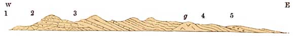
Fig. 55.
1. Lower Silurian rocks, with crystalline limestone.
2. Old Red Sandstone.
3. carboniferous strata.
Again, if we examine the map of Scotland, we find a broad band of Old Red Sandstone running from Stonehaven on the east
coast to Dumbarton on the west, and there also masses of conglomerate lie at the
base, as in No. 2, fig. 56. Overlooking this broad band, the Grampian mountains No. 1 rise
high into the air, still reminding the beholder of the ancient line of coast of a vast inland lake,
against which the waves of the Old Red Sandstone waters beat, and from its partial
waste, aided by glaciers and the work of coast-ice, formed the boulder-beds that now make part
of the conglomerates. We are thus justified in coming to the conclusion that the North Highlands generally formed land before the time of the Old Red Sandstone, the Grampian mountains, even then separated
from the Scandinavian chain, as a special range forming a long line running from north-east to south-west, the bases of its hills being washed by the waters which deposited the Old Red Sandstone itself.
What amount of denudation the gneissic mountains of the Highlands underwent, before and during the deposition of the
Old Red Sandstone, it is impossible to determine, but it
[288 Older Mountains.]
must have been very great. I consider it certain, that from these mountains glaciers descended through
ancient valleys, now lost, and indeed that other sub-angular conglomerates
of the Old Red Sandstone in various parts of Britain consist of stratified
moraine matter. All the ordinary influences of terrestrial waste—rain, rivers,
frosts, snow, ice, wind, and waves—were at work sculpturing the surface of
that old land, and on the very same land they have been at work from that
day to this. What was the precise form of the highlands that bordered this
Old Red Sandstone lake, it is now impossible to know, except that it was
mountainous; but this is certain, that after the early disturbances of the
strata, the general result of all the wasting influences, acting down to
the present day, has been to produce the present scenery. Thus it is certain
that all the Cambrian and Laurentian rocks of the north-west of Scotland,
were once buried deep beneath Lower Silurian gneiss thousands of feet thick;
that on the west these Silurian strata have been, in places, almost utterly
worn away, and the Cambrian rocks, as in Suilven, have thus been exposed
and moulded into an outlier by subsequent waste. Some of these mountains
in Sutherland now form the grandest and most abrupt peaks of the north-west
Highlands, standing, steepsided and high like Suilven, isolated, on a broad
raised platform of Laurentian gneiss. And just as a railway navigator leaves
pillars of earth in a railway cutting, to mark how much he has removed, so
the great excavator, Time, has left these mountain landmarks to record the
greatness of his operations.
It is at first hard to realise these facts, but observation and reflection combined lead to this
inevitable result.
FIG. 56.
 View of Suilven, Canisp, and the neighborhood, Sutherland.
Suilven, 2396 feet high, in the middle of the drawing.
290 Lammermuir Hills.
If we again examine the Map, we find that a large
tract of country, forming great part of the Lowlands,
stretches across Scotland from north-east to south-west, including the Firths of Tay and Forth,
and all the southern and eastern shores of the Firth of Clyde. This area is occupied by Old Red
Sandstone and rocks of Carboniferous age (Nos. 2 and 3, fig. 55), mostly stratified, but partly
igneous. To the south lie the heathy and pastoral uplands known as the Carrick, Moorfoot,
Pentland, and Lammermuir Hills, marked 1', which, like the Highlands, are also chiefly formed
of Silurian rocks, but much less altered, and rarely possessing a gneissic character. These
plunge beneath the Old Red Sandstone, and rise in the Grampian mountains on the north changed
into quartz-rock, mica-schist, and gneiss. The unaltered Carboniferous and Old Red Sandstone
rocks thus lie, as a whole, in a hollow, between the Grampian and the Lammermuir ranges, the
coal-bearing strata chiefly consisting of alternations of shale, sandstone, limestone, and coal,
mingled with volcanic products of the period.
I have already explained, in Chapters VIII. and IX how these Old Red and Carboniferous rocks
were formed, showing that the latter consist of strata partly of freshwater and partly of marine
origin, for not only are the limestones formed of corals, encrinites, and shells, but many of the
shales also yield similar fossils, while some strata are charged with fresh-water shells. Beds of
coal are numerous, and under each bed of coal there is a peculiar stratum, which often, but not
always, is of the nature of fire-clay, and is sometimes called 'underclay,' this in England being
a miner's term, on account of its position beneath each bed of coal. As already explained, the
'underclays' were the soils on which land plants
[Hills of Igneous Rocks. 291]
grew, and from this it is plain that the conditions attending the deposition of the Carboniferous
strata, were in great part terrestrial.
In the Scottish Coal-measures there are in Edinburghshire over 3,000 feet of coal-bearing
strata, so that the lowest bed of coal may be nearly three thousand feet below the highest bed, in
the centre of the basin, where the strata are thickest. Most of the beds rise, or ' crop,' as
miners term it, to the surface somewhere or other, this 'outcrop' being the result of
disturbance of the strata and subsequent denudation, and it is by means of this disturbance and
denudation that we are enabled, by an easy method, to estimate the thickness of the whole mass
of strata, and to prove that one bed lies several thousands of feet below another.
In the Scottish area, during
the formation of part of the Old Red Sandstone and of the Coalmeasures, many
volcanoes were at work; and thus we have dykes and bosses of felspathic trap
and greenstone, and interstratifications of old lava streams, and beds of
volcanic ashes mingled with common sedimentary stxata. These, being often
harder than the sandstones and shales with which they are interbedded, have
more strongly resisted denudation, and now stand out in hilly ranges, like
the Pentland, Ochil, and Campsie Hills, the Renfrewshire and Ayrshire Hills
on the Clyde, or in craggy lines and bosses, like Salisbury Crags, the Lomonds
of Fife, and the Garlton Hills in Haddingtonshire, which give great diversity
to the scenery, without ever rising to the dignity of mountains.
Having thus briefly rehearsed the mode of formation of the more important Scottish formations,
we may already begin to perceive what is the cause of the
[292 Analysis of the]
mountainous character of the Highlands, and of the softer features of the Lowlands. It is briefly this:
that, in very ancient geological times, before the deposition of the Upper Silurian series and Old
Red Sandstone, the Lower Silurian rocks, which form almost entirely the northern half of
Scotland, had already been raised high into the air, metamorphosed, and greatly disturbed. Such
metamorphic rocks, though, as a whole, difficult of destruction, yet consist of intermingled
masses of different degrees of hardness, whence the great variety of their outlines is the result
of the softer rocks having been most easily worn away. In the south of Scotland, from Galloway
to the coast of Berwickshire, the same strata, forming the upland of the Carrick, Moorfoot, and
Lammermuir hills, have been equally disturbed, though perhaps not originally raised to the
same height, but being comparatively unmetamorphosed, they are generally somewhat less
hard, and have therefore been more wasted by denudation, whence their average lower elevation.
Though the mountains of these southern Highlands cannot compare in height with those of the
north, they are sometimes both striking and picturesque in outline, especially where associated
as gneiss and other metamorphic rocks with great bosses of granite and quartz-porphyries, in
Wigtonshire, Kirkcudbrightshire, and Selkirkshire, in the south of Scotland. These gneissose
lines run in the general strike of the strata, all the way from Lauderdale, to the cliffs of the
Rhinns of Galloway that bound St. Patrick's Channel.
Nothing can be more impressive, in its way, than the noble amphitheatre of hills that surround
the sombre moorland basins of Loch Doon, Loch Finlas, and the smaller lakes and tarns that lie
further south and west of the Rhinns of Ketts, the highest granitic peak of
[Scenery of Scotland. 293]
which has an elevation of 2,668 feet above the sea. Magnitude is not always essential to
grandeur, and as in human, so in nature's architecture, proportion of parts often strikes the
mind with a sense of majesty which is wanting in larger bulks.
If we take the area of these southern Highlands, it amounts to about 6,000 square miles, in
which the greater hills vary from 1,300 to 2,695 feet in height, in the east the highest being
Seenes Law 1,683 feet, further west Black Hope Scaur, 2,136 feet, still further west
Whitecombe Edge in Berwickshire 2,695 feet, and further west still, the Rhinns of Ketts
2,668 feet. In the whole district, more than half the area is under 1,000 feet in height, by far
the larger part of the remainder between 1,000 and 2,000 feet; and all the remainder, above
2,000 and under 2,668 feet, occupies a small area of about 75 square miles.
If we turn to the true Scottish Highlands, there we find more than a dozen of mountains the
heights of which exceed 3,000 feet, including Ben Klibreck 3,157 feet, Ben Hope 3,061 feet,
and Ben More 3,281 feet in height, all in Sutherland. In Ross there are Ben Dearig 3,551 feet,
Ben Wyvis 3,720 feet, and Sleugach, said to be 4,000 feet in height. In Inverness-shire, Ben
Attowe, also 4,000 feet high; while south and south-east of the string of lakes in the Great Glen,
of which Loch Ness is one, there are Ben Voirlich 3,180 feet, Ben Lomond 3,192 feet, Glas
Mhiul 3,501 feet, Ben Dearg 3,918 feet, Ben Lawers 3,984 feet, Cairn Gorm 4,090 feet, Ben
Mac Dhui 4,296 feet, and Ben Nevis 4,406 feet in height. If next we take the whole area of the
Lower Silurian rocks of the Highlands, between the Great Glen and the south-eastern slope of
the Grampian Mountains, it appears that not one-third of the country
[294 Analysis of the]
is more than 500 feet, above the sea, of the remainder less than a quarter ranges between 500
and 1,000 feet in height, while of the rest a large part ranges between 1,000 and 2,000 feet;
and after that, about as much remains between 2,000 and 4,406 feet in height, as would cover
half the area of the Lower Silurian hills, of what I have called the south Highlands, between
Berwickshire and Wigtonshire.
Beyond Glen More and the Caledonian Canal, as far as the north coast of Scotland, the Highlands
have the same general character, though the amount of ground above 2,000 feet in height is
comparatively less in the total area, and this amount gradually decreases in proportion the
further north we go. Section No. 54, page 285, gives an idea of the general contours in north
Sutherland. There, on the flanks of the mountains in Caithness, the Old Red Sandstone, lying in
comparatively flat strata, forms an undulating plain consisting of conglomerates on the west,
and chiefly of sandstones from thence to Sinclair Bay, where it slips under the sea, while
further south, between Noss Head and Bervie Ness, high cliffs overlook the sea.
South of Strath Ullie or Helmsdale, the same Old Red Conglomerates and Sandstones skirt the
Silurian rocks, crossing the Firths of Dornoch, Cromarty, and Inverness, and Beauly Basin, and
stretching south to the noble mountain of Mealfourvounie, 3,060 feet in height, from whence,
crossing Loch Ness, it skirts the country in a broad band beyond the mouth of the Spey. In all
this area a large part of the strata consists of conglomerate, and where this rock occurs,
because of its occasional hardness, and the very considerable disturbance of the rocks, some of
the country ranges between
800 and nearly 1,500 feet in height. In no part of
[Scenery of Scotland. 295]
Scotland that, I know, are the conglomerates (made of the waste of the older Silurian
mountains) more striking than in this region, and the glacial origin of some of them to my mind
is unmistakable, especially on the shores of the Beauly Firth near Drynie. All the embedded
stones have been derived from the old Silurian mountains, some of them are from four to five
feet in diameter, and many of them are subangular in shape, just like the boulders in much of
the glacial detritus of what is ordinarily called the Glacial epoch.
In time, the Old Red Sandstone period came to an end, and above that series—for it consists of two
members, the upper member of which lies unconformably on the lower—the Carboniferous
rocks were formed. The whole were then again disturbed together—a disturbance not confined to
Scotland only, but embracing large European and other areas.
But before the deposition of
the Old Red and Carboniferous series, there is reason to believe that a wide
and deep valley already existed between the Grampian mountains and the Carrick,
Lammermuir, and Moorfoot range; and in this hollow the Old Red Sandstone
was deposited, partly derived from the waste of the Silurian hills on the
north and south. But by-and-by, as deposition progressed, the land began
to sink on the south, and the upper strata of Old Red Sandstone overlapped
the lower beds, and began, as it were, to creep southwards across the Lammermuir
Hills, which, sinking still further, were in turn invaded by the lower Coalmeasures
and Carboniferous Limestone series. It appears, therefore, from a consideration
of all the circumstances connected with the physical relations of the strata,
that the Coal-measures once spread right across the Lammermuir range, and
were united to the Carboniferous
[296 Analysis of the]
strata that now occupy the north of England, thus, with part of the Old Red Sandstone, covering
great part of the Silurian strata of the south of Scotland. This unconformable covering has,
however, in the course of repeated denudations, been removed from the greater part of that high
area, and now the Carboniferous strata are only found in force in the great central valley
through which flow the rivers Forth and Clyde.
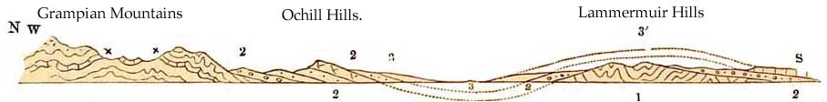
This will be easily understood by referring to the section, fig. 55, across the central valley of
Scotland, from the Grampian mountains to the Lammermuir hills, in which the following
relations of the various formations are shown.
The gneissic rocks of the Grampian mountains (No. 1), with bands of Limestone marked +, pass
under the Old Red Sandstone (No. 2), and rise again, highly disturbed, but not much
metamorphosed, in the Lammermuir hills (1'). On these the lower conglomerates of the Old Red
Sandstone (No. 2) lie unconformably, adjoining and overlying which, there is a series of beds of
red sandstones which generally dip SE. for a space about ten miles in breadth, as seen, for
example, on either side of Strath Earn and the Tay above Perth. These are succeeded by an upper
series of Old Red Sandstone rocks, which run from the neighbourhood of Stirling to the estuary
of the Esk, near Moritrose, on the east coast, and to Cupar and the mouth of the Firth of Tay, at
Ferryport. The lower part of this upper series is often interstratified with volcanic lavas, ashy
breccias, and conglomerates of a feispathic nature. These being hard and dipping south-easterly
from the Forth to the mouth of the Tay, generally form a high escarpment, the steep-scarped
front of which faces to the north-west, in accordance with a law that, on a great scale, rules the
[Scenery of Scotland. 297]
mode of formation of such slopes, the more gentle inclines being in the direction of the dip, and
the steep scarp sloping at right angles to the average inclination of the strata. (See fig. 55, p.
287).
Let anyone who wishes to see this effect, walk to the summit of the Ochil Hills, and there, from
the edge of the scarp, he will see in the main a gentle slope to the south-east, while below, on
the north-west, the delighted eye ranges across the fertile plains and undulations of the Teith,
Strath Allan, and Strath Earn, while, far beyond, this almost unrivalled view is bounded by the
lofty chain of the Grampian Mountains. Let the reader also understand that the whole of the
Lower Old Red Sandstone as far as the Grampians was once buried deep under this upper series,
and he will then begin to realise the prodigious amount of denudation that the region has suffered
before it assumed its present aspect.
Above and merging into the Old Red Sandstone come the Carboniferous rocks No. 3, fig. 55, lying
in a wide faulted and denuded synclinal curve,1 but with many a high boss of basalt standing out
in bold relief in the midst. Such are the Lomonds of Fife, Dunker Law, and Bishop Hill, north of
the Forth, while south of that estuary Arthur's Seat forms a well-known example, and the
pastoral tract of the Pentland Hills, formed of Upper Old Red Sandstone, mingled with
contemporaneous igneous rocks, stand in high relief above the fertile plains of Midlothian and
Dalkeith.
I have already stated that the southern continuation of the Upper Old Red and Carboniferous
strata once spread over the Lammermuir Hills in a kind of anticinal curve, in the manner
shown by the dotted lines No. 3', on the diagram fig. 56.
1
The diagram is, however, too small to show these breaks.
[298 Old Red Sandstone and]
Now why is it that the Carboniferous and Old Red Sandstone rocks have been specially preserved
in the great valley, and almost entirely removed from the upland region of the Laminermuir
hills? The reason is this:—
When strata have been thrown into a series of anticlinal and synclinal curves, it has frequently
happened that those parts of the disturbed strata that were thrown downwards, so as to form
deep basin-shaped hollows, were by this means saved, for long periods of time, from the effects
of denudation, while the upper parts of the neighbouring anticlinal curvatures, being exposed to
all the wasting influences of the air, rain, rivers, and the sea, were denuded away.
In other words, some widely
extended portions of the strata lay so deep that no wasting influence had
access to them, and they have escaped denudation, and the basin—as geologists
term it—remains. This is the reason why so many coal-fields lie in basins.
It is not, as used to be supposed, that the Carboniferous beds were deposited
in basins, but that by disturbance part of the strata were thrown into that
form, and saved from the effects of denudation. Such basins are, therefore,
equally common to all kinds of formations; though, because they rarely contain
substances of economic value, they have not met with the same attention that
Coal-basins have received.
In the case now under review it happens that the Old Red Sandstone and Carboniferous rocks lie
in the hollow, and, though much worn away and fragmentary, they have been to a great extent
preserved; while the continuation of part of the same formations that lay high in an anticlinal
form, and originally spread over the Lammermuir hills (3'), has been almost all removed
[Carboniferous Strata. 299]
by denudation. The reason of
this is, that during frequent oscillations of land, relatively to the level
of the sea, the higher ground was much more often above water than the lower
part, and therefore exposed to waste and destruction. To understand this
thoroughly, let us suppose that the whole of the formations now forming this
area were, in an ancient epoch, underneath the sea, and then let parts of
it be raised, more or less above that level, well into the air. Part of the
area now known as the Lammermuir Hills, then covered by Old Red Sandstone
and Coal-measures, rose above the water, and was immediately subjected to
the wear and tear of breakers on the shore, and of rain, rivers, frost, and
other atmospheric influences; while, on the other hand, that portion that
lay deep in the syndinal curve was beneath the level of the sea, and thus
escaped denudation, because no wasting action takes place in such situations.
By geological accidents such as these, the greater features of Scottish scenery have been
produced. The Highlands are mountainous because they are composed of rocks much disturbed,
metamorphosed, and mostly crystalline, and intermingled with great and small bosses of hard
granite. All of these rocks having been often and long above water, have been extremely denuded:
such denudations having commenced so long ago, that they date from before the time of that
extremely venerable formation, the Old Red Sandstone, probably indeed ever since what, for
want of better words, we term the close of the Lower Silurian epoch, and the waste has been
going on, more or less, down to the present day.
Being formed for the most part of materials of great but unequal hardness, and associated with
masses
[300 Highland Mountains and Denudation.]
of granite, the high land has been cut up into innumerable valleys by the repeated action of rain,
rivers, and glaciers, whence their mountainous character; for the special outlines of
mountains, as we now see them, are rugged, less by disturbances of strata, than by the scooping
away of material from greatly elevated tracts of country. By mere elevation and disturbance of
strata, the land might rise high enough; but as mountain regions now exist, it is by a
combination of disturbance of strata with extreme denudation, going on both while and after
slow disturbance and elevation was taking place, that peaks, rough ridges, ice-worn surfaces,
and all the cliffs and valleys of the Highlands in their present form, have been called into
existence. They are undergoing further modification now.
Let anyone go to the western part of Sutherland and climb Suilven, and he will get a clear idea of
what is meant by a considerable amount of denudation. The mountain is based on a wide, low,
undulating plateau of Laurentian gneiss, dotted with unnumbered lakes and tarns. From this
plateau it rises abruptly into the air, like a little Matterhorn, 2,396 feet in height, and its
sides are as steep as those of the noble Swiss mountain. They are formed of horizontal Cambrian
purple conglomerate and grits, cut by nature into great terraced steps, on which by devious
courses the climber reaches the summit. From thence let him turn to the east, and there, five
miles distant, set on the same plain, he will descry the steep-sided Canisp, formed of the same
Cambrian strata once united to those of Suilven, and Coulmore. Here is 'a monstrous cantle' cut
out of these strata, and yet if the reader, for the whole, would multiply that by a hundred, he
would probably not
[Lammermuir Hills. 301]
exaggerate the amount of denudation that these ancient rocks have suffered in the Highlands.1 Fig.
56, p. 289.
Farther south the different nature, both of the Silunan and newer rocks, coupled with other
geological accidents, have produced the great valleys of the Forth and Clyde, and the tamer but
still hilly scenery of the Southern Highlands, as they are sometimes called These consist mainly
of the Lammermuir, Moorfoot, and Carrick Hills, now often massed under the name of the
Lammermuir range. But they are not a range. They consist in reality chiefly of a tableland, or
old plain of denudation, older for the most part than the Old Red Sandstone and Carboniferous
rocks; which plain, after being long buried, was subsequently again exposed by denudation of the
overlying strata.
The present scenery of hill
and valley in the southern part of Scotland is therefore, in great part,
the result of the waste of this old tableland, and the scooping out of valleys
and lakebasins, by rain, rivers, and old ice, which, as a great ice-sheet,
at one time covered the whole of Scotland and much more besides. The effects
of this were, in later times, modified by minor glaciers, during those oscillations
of temperature that marked what we now call the Glacial epoch, and all the
ordinary water produced by rain and rivers is modifying the scenery now.
1 For cases in point see my memoirs on 'The Geology of North Wales,' and 'On the Denudation of
South Wales and the Adjacent Counties,' 'Memoirs of the Geological Survey,' vol. i., 1846.