[336]
CHAPTER XXI.
THE ORIGIN OF ESCARPMENTS, AND THE DENUDATION OF
THE WEALD—GREY WETHERS AND THE DENUDATION OF THE EOCENE STRATA.
IN the foregoing pages much has been said about escarpments. The origin of all escarpments,
excepting modern sea cliffs, is generally the same, and they are nearly all marked by this
peculiarity, that the strata dip at low angles in a direction opposite to the slope of the scarp,
thus:
FIG. 70.

1. Strata with a low dip, e escarpment.
2. Detritus slipped from
the escarpment down towards the plain p.
The Weald of Kent and Sussex and the surrounding Chalk hills form excellent examples of what I
wish to explain, and I therefore return to the south-east of England. In the Wealden area we
generally find a plain, bounded by hills of Lower Greensand and Chalk, on the north, south, and
west, while the clayey plain itself surrounds a nucleus of undulating sandy hills in the centre.
The whole of this Wealden area forms a great amphitheatre, on the outermost rim of which the
[the Weald. 337]
Chalk rises in bold escarpments, forming what are known as the North and South Downs. On the
east it is bounded by the sea. There can be no doubt that the Chalk and the underlying formations
of Upper Greensand, Gault, Lower Greensand, and Weald Clay originally extended across all the
area of the Weald for a breadth of from twenty to forty miles from north to south, and nearly
eighty from east to west (figs. 71 and 73). This vast mass, many hundreds of feet thick, has
been swept away, according to an opinion formerly universal among geologists, by the wasting
power of the sea, but, I believe, chiefly by atmospheric agencies; so much so, indeed, that I am
convinced that all the present details, great and small, of the form of the ground, are due to the
latter. The result is, that great oval escarpments of Lower Greensand, and outside of that of
Chalk surrounding the Wealden area, rise steeply above the nearest plain, which is composed of
the Weald Clay, from beneath which the Hastings Sands crop out, forming a central nucleus of
hilly ground, in the manner shown in the following diagram, the height of which is purposely
exaggerated so as to bring the features prominently before the eye.
FIG. 71.
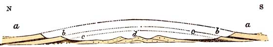
a a Upper Cretaceous strata, chiefly Chalk, forming the North and South Downs; b b escarpment
of Lower Greensand with a valley between it and the Chalk; c c Weald Clay, forming plains; d
hills formed of Hastings Sand and Clay. The Chalk, &c. once spread across the country, as shown
in the dotted lines.
Let us endeavour to realise how such a result may
[338 Denudation of]
have been brought about. The idea that the Wealden area once formed a vast oblong bay, of which
the Chalk hills were the coast cliffs, is exceedingly tempting; for, standing on the edge of the
North Downs near Folkestone, and looking west towards Ashford, and south-west across the
Romney Marsh, it is impossible not to compare the great flat to a sea overlooked by all the bays
and headlands, which the winding outlines of the Chalk escarpment, both of the North and South
Downs, are sure to suggest. And in less degree the same impression suggests itself, wherever
one may chance to stand on the edge of the Chalk Downs, all the way from Folkestone to Alton and
Petersfield, and from Petersfield to Eastbourne. For years, with others, I held this view; but
for years, with me, it has passed into the limbo of hypotheses no longer tenable.
If the Wealden area were lowered into the sea just
enough to turn the Chalk escarpments into sea-cliffs (see
Map and fig. 72), we should have the following general results. Let the line a b represent the
present sea level, and the lines s s s the level of the sea after depression; then, so far from the
area presenting a wide open sea, where heavy waves could play between the opposite North and
South Downs, we should have an encircling cliffy coast of chalk c; the base of which cliff, if we
follow the escarpment all round from the neighbourhood of Folkestone to that of Eastbourne,
unlike all common coasts, would in some cases be washed by the ordinary tides, while within a
mile or two, the depth of the sea close to the cliff of chalk must have been from 200 to 300 feet.
In other words the base of the Chalk and Upper Greensand all round the Weald from Folkestone to
Eastbourne could not have formed a continuous shore line in recent times, for some
[the Weald. 339]
FIG. 72.
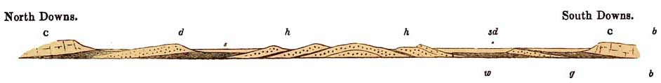 Diagram showing the general effect of a partial submergence of the Weald. Map, line 10.
c c Chalk and Upper Greensand forming North and South Downs.
g Gault generally forming a
plain.
s d Escarpments of Lower Greensand.
w Weald clay generally forming a plain.
h h Central hills of Hastings Sand.
[340 Denudation of]
parts of it are at the sea level now; while other parts, along gently undulating lines at the bases
of the North and South Downs, rise to more than 250 feet above the sea.
On the supposition that the Wealden area was once an oblong bay, this land would also have been
formed of two narrow strips of country, one on the south at least 60, and the other on the north
not less than 100, miles long, both of which project eastward from the Chalk of Hampshire, to
form what we now call the North and South Downs. These hills generally rise high above the
Eocene strata that skirt them on the north and south, and these Eocene beds, under the supposed
circumstances, would be covered by sea, while the scarped cliffs of Chalk, as shown on the
diagram, would overlook a sea-covered plain of Gault g; outside of which, near the shore, would
be a series of ridgy islands of Lower Greensand s d, which, at present, in some parts of the
country, rise into escarpments higher than the Downs themselves. Beyond these there would be
a sea where the flats of Weald Clay w now lie; inside of which would rise an island, or rather
group of islands, formed of the Hastings Sand series h h. This form of ground would certainly be
peculiar, and ill adapted in form to receive the beating of a powerful surf, so as to produce on
the inner side only, the cliffy escarpment that forms the steep edge of the oval of Chalk.
Further, if the area had been filled by the sea, we might possibly expect to find traces of
superficial marine strata of late date, as in some other parts of England, scattered across the
surface between the opposite Downs. But none of these traces exist. On the contrary, the
underlying strata of the Cretaceous and of the Wealden series everywhere crop up and form the
surface of the ground,
[the Weald. 341]
except where here and there, near the Chalk escarpments, they are strewn with flints, the
relics of the subaerial waste of the Chalk, or where they are covered by freshwater sands,
gravels, and loams of the ancient rivers of the country.
I believe, therefore, that the form of the ground in the Wealden area, which was once attributed
to marine action, has been mainly brought about by atmospheric causes, and the operation of
rain and running waters. One great effect of the action of the sea, combined with atmospheric
waste, when prolonged over great periods of time, is to produce extensive plains of marine
denudation like the line b b, fig. 97, p. 497; for this combined result is to plane off, as it were,
the asperities of the land, and reduce it to an average tidal level.
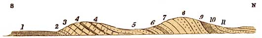
Suppose the curvature of the various formations across the Wealden area to be restored by
dotted lines, as in figure, No. 73, which is very nearly on a true scale. Let the upper part of the
curve be planed across, as shown in fig. 73, and let the newly-planed surface, slightly inclined
from the interior, be represented by the line p p. Against this line, the various masses of the
Hastings Sand h h, Weald Clay w, the Lower Greensand s, the Gault g, and the Chalk and Upper
Greensand c, would crop up. Then I believe that, by aid of rain and running water, large parts of
these strata would be cut away by degrees, so as to produce in time the present configuration of
the ground. If it were not so, we might expect that the rivers of the Wealden area should all flow
out at its eastern end, through long east and west hollows, previously scooped out by the
assumed wasting power of the sea, where the ground is now low, and looks out upon the sea,
[342 Denudation of]
and towards which, the long plains of Gault and
Weald Clay directly lead. But this, except with certain rivulets, is so far from being the case,
that some streams, like the Beult, rise close to the sea coast and flow westward. If, on the other
hand, such a plain as p p once existed, it is easy to understand, how the rivers in old times
flowed from a low central watershed to the north and south across the top of the Chalk, at
elevations at least as high as, and probably even higher than the present summit-levels of the
Downs.
Then, as by the action of running water, the general level of the inner country was being
unequally reduced, so as to form tributary streams each cutting out its own valley, the greater
rivers, augmented in volume by these tributaries, were all the while busy cutting and
deepening those north and south channels through the Chalk Downs now known as the valleys of
the Stour, the Medway, the Dart, the Mole, the Wey, which run athwart the North Downs, and
the Arun, the Adur, the Ouse, and the Cuckmare, which, through gaps in the South Downs, flow
south.1 On any other supposition, it is not easy to understand how these channels were formed,
unless they were produced by fractures or by marine denudation, of neither of which is there
any proof. Through most of these gaps no known faults run of any kind, and the whole line of the
Chalk is singularly destitute of fractures.
We get a strong hint of the probability of the truth of this hypothesis of the denudation of the
Weald in
1 This kind of argument was applied by Mr. Jukes to explain the behaviour of some of the
rivers of Ireland, and he supposed that it might possibly apply to the Weald.—' Geological
Journal,' 1862, vol. xviii. p. 378.
[the Weald. 343]
FIG 73.
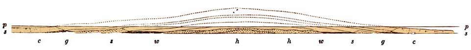 Diagrammatic section. across the Weald, with the anticlinal curve restored as high as the Chalk.
Map, line 11.
Diagrammatic section. across the Weald, with the anticlinal curve restored as high as the Chalk.
Map, line 11.
s s The level of the present sea.
p p The level of the old, plain of marine den'udation, after the dotted parts had been planed or
denuded off.
c c Chalk and Upper Greensand, g g Gault, s s Lower Greensand, w w Weald Clay, h h
Hastings sand.
Part at least of the Eocene beds probably lay above the curied strata of Chalk marked in the
dotted line.
[344 Denudation of]
the present form of the ground. Thus after the formation of the marine plain p p, the Chalk
being comparatively hard, has been partly denuded, and now stands out as the bold escarpments
of the North and South Downs. The soft clay of the Gault has been more easily worn away, and
forms a hollow or plain between the Chalk and the Lower Greensand. The Lower Greensand, full
of hard calcareous bands and ironstone, more strongly resisting denudation, forms a second
range of scarped hills, overlooking the more easily wasted Weald Clay, which makes a second
and broader plain, from under which rise the subdivisions of the Hastings Sands, forming the
undulations of the hills of Ashdown Forest, and other places, in the broad centre of the low
anticlinal curve. The absence of flints over nearly the whole of the Wealden area, excepting near
the Downs, is easily explained by this hypothesis, for the original marine denudation had
removed all the Chalk, except near the margin (see fig. 73), long before the rivers had begun
simultaneously to scoop out the valleys of the interior, and to cut the transverse valleys across
the North and South Downs.1
Given sufficient time, I see no difficulty in this result. But the question arises, how much time,
in a geological sense, can be given?
It is believed that, excepting for a few feet close upon the coast, this southern part of England
was not depressed beneath the sea during any part of the Glacial period. It has, therefore, been
above water for a very long time. On the edge of the North Downs there are
1
The original sketch of these views was published in 1863, and enlarged and much improved in
1864, in a second edition of this work. For greater detail on the same subject, see Foster and
Topley, 'Journal of the Geological Society,' 1865, vol. xxi. p. 443.
[the Weald. 345]
certain fragmentary outliers described by Professor Prestwich. These by some persons have
been supposed to be outliers of the Lower Eocene strata, called the Woolwich and Reading beds,
but Professor Prestwich considers them to belong to part of the Crag. The physical evidence
seems to me to be in favour of the former.
If they belong to any part of the Eocene series, then, as they lie as it were accidentally
conformably on the Chalk, they were evidently affected by the disturbance that raised the
Wealden into an anticlinal curve, and depressed the Chalk and overlying Eocene beds
into the now divided synclinal curves of the London
and Hampshire basins, and therefore, the beginning of the chief denudation of the Weald, by
which it gradually assumed its present form, was post-Eocene. Under these circumstances it is
probable that the Eocene beds themselves were cut across during the gradual formation of the
plain of marine denudation. On the other hand, if the outliers on the Chalk escarpment west of
Folkestone be parts of the Crag beds, then it is possible that strata of the Crag may have been
deposited upon that plain, and found their way into those isolated petty potholes in which the
fossils were found, and in that case the bay-like denudation of the Weald has probably taken
place since that epoch, implying a lapse of time so long, that by natural processes alone, nearly
half the marine mollusca, and probably nearly all the terrestrial species of mammalia of the
world, have disappeared and been slowly replaced by others. This may mean little to those who
still believe in the sudden extinction of whole races of life; but to me it signifies a period
analogous to the distance of a half-resolved nebula, the elements as yet being wanting
[346 Denudation.]
by means of which we may attempt to calculate its remoteness.
I have gone so far into details on this subject, because the 'Denudation of the Weald' has given
rise to much theorising by distinguished authors, and I wish to show the reasons why I think
that the amphitheatre-like form of the area, and the escarpment of the Chalk, are not due to
marine denudation or the beating of sea waves. On the contrary, the outer crust of Chalk that
once cased the whole as the strata of the anticlinal curve having been planed off, and by
subsequent elevation a tableland having been formed, the softer rocks below that cropped up to
the surface of this plane were then attacked by running water, and worn away so as to form by
degrees the hills and valleys of the district, including the great escarpment of the North and
South Downs.
Though the Secondary and older Tertiary strata of England generally lie flat or dip at low angles,
yet in
FIG. 74.
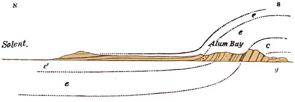 Section across the Isle of Wight.
g, Lower Greensand; c, Chalk; e, Woolwich and Reading beds,
London Clay and Br&,klesham and Bagshot Sands, and the overlying Freshwater strata é.
one instance they have been very considerably disturbed;
for on a line which runs through the Isle of Wight and
[Denudalion. 347]
the Isle of Purbeck they stand nearly on end. Those who are familiar with the Isle of Wight will
remember that from east to west, or from White Cliff Bay to Alum Bay, there is overlying the
Lower Greensand g, a long range of Chalk hills, c, the strata of which dip towards the north, and
are overlaid by the older Tertiary strata e, that is to say, the Woolwich and Reading beds, the
London Clay, the Lower Bagshot Sands and Clays, the Bracklesham Beds, the Upper Bagshot
Sands, and all the higher freshwater and estuarine divisions é, as enumerated in the column p.
30, and in the diagram, p. 241.
The whole pass under the Solent, as shown in the lower dotted lines e é, fig. 74, and rise again
on the mainland in Hampshire, a considerable portion of which is composed of various
subdivisions of the Eocene rocks. The same general relations of the Secondary and Eocene strata
are seen on the mainland in the Isle of Purbeck, at and west of Swan age, as shown in the
following section north of Kimeridge Bay (fig. 75).
FIG. 75.
Section across the Isle of .Purbeck.
1. Kimeridge Clay. 2. Portland
Oolite sand. 3. Portland Oolite limestone. 4. Purbeck limestone and mans,
chiefly freshwater beds. 5. Weald sands and clay, freshwater. 6. Neocomian
and Greensand. 7. Chalk without flints. 8. Chalk with flints. 9. Woolwich
and. Reading beds. 10. London Clay. 11. Bracklesham and Bagshot beds.
Now these disturbed strata of the Isle of Wight were deposited horizontally, and after
disturbance, the Chalk, C, spread over an extensive area of Lower Greensand,
[348 Denudation of]
g, to the south, and the Eocene rocks e once spread over the Cretaceous rocks in a curve, at a
great height, as shown in the dotted lines e e (fig. 74). Taking the whole of the south-eastern
part of England, from Suffolk to Beachy Head, and westward to Salisbury and Dorchester, the
sections shown in figs. 74 and 75 merely form part of the two great antidinal and synclinal
curves of which the Hampshire and London basins form parts. Here then in our Secondary and
Tertiary rocks we get evidence, though in less degree, of the same kind of disturbance and
denudation of which we have such striking proofs when we consider the structure of the
countries in the western and northwestern area, which are composed of Palaeozoic rocks. In the
central part of England the Secondary and Tertiary strata, not having been so much disturbed,
have necessarily not been so much denuded in height, but chiefly backwards from west to east.
I have still a few words to add respecting the denudation of the Eocene strata. Some of these beds
in the Woolwich and Reading and in the Bagshot series consist of sands, portions of which
become exceedingly hard, especially when exposed to the air. I have already said that these
formations, together with the Chalk, once spread much further to the west than they do now,
because outlying patches of Eocene rocks occur here and there almost at the very edge of the
great Chalk escarpment, as shown in fig. 61, p. 320. Part of the original continuation of both in
a westward direction is shown in the dotted lines in the same diagram.
It so happened that when the wasting processes took place that wore away both these formations
from west to east, the softer clays and part of the sands of the Eocene
[Eocene Strata. 349]
strata were more easily removed than the harder rocky portions, and the result is that over
large areas, such as Marlborough Downs, great tracts of Chalk are strewn with huge blocks of
tabular quartz-grit, lying so close together that some years ago, over miles of country, I could
almost leap from block to block, without touching the chalk on which they lie. They are,
however, in such great request for building and paving purposes, that in the long run they will
probably be all broken up and carried away.
FIG. 76.
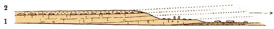
In the above figure, No. 1 represents the Chalk, and 2 the overlying Eocene clays and sands; and
the isolated blocks, lying directly on the topmost beds of the Chalk, represent the thickly
scattered masses of stone left on the ground after the removal by denudation of other and
softer parts of the Eocene, strata, No. 2. Frequently these masses are found scattered even on the
terraces of the Lower Chalk, a remarkable example of which occurs at the Prehistoric town of
Avebury, near which, the lower terrace of Chalk (as in the diagram) is strewn with 'grey
wethers,' as they are termed, and immense masses of these, set on end by a vanished people,
stand in the ancient enclosure. Sometimes even on the plains of Gault or Kimeridge Clay, well
out to the north or west of the escarpment, as for instance at Swindon, and also in the Wealden
area, blocks angular or halfrounded lie in the meadows, marking the immense waste to which
the whole territory has been subjected long after the close of Eocene times. They plainly tell,
that the Chalk and overlying Eocene beds once
[350 Grey Wethers.]
spread far across the plains which the abrupt Chalk escarpments now overlook. These have been
and are still being wasted back, for they are comparatively easily destroyed, but the strong
'grey wethers' remain, and as the rocks on which they once lay were slowly wasted away and
disappeared, these masses of tough and intractable silicious stone gradually subsided to their
present places.
Besides the name of 'grey wethers,' they are also known as Sarsen stones, and Druid stones, and
all the standing masses of Avebury and Stonehenge, popularly supposed to be Druidical temples,
have been left, by denudation, not far from the spots where they have since been erected into
such grand old monuments by an ancient race.1
I might add many details respecting the origin of the scenery of other portions of England, such
as the relation of the secondary rocks to the older rocks of Devon, the structure of the Malvern
Hills, a true miniature mountain range, and of the Mendip Hills, or of the beautiful Vale of
Clwyd, in North Wales, consisting of a bay of soft New Red Sandstone, bounded by Silurian
mountains and old limestone cliffs, and of the still larger Vale of Eden, in the North, where the
mountains of Cumberland look down on an undulating ground formed of Permian and partly of
New Red strata (fig. 104, p. 521). But some of these regions will be dealt with when I discuss
the subject of the British rivers, and in the meanwhile it would not
1 The smaller stones at Stonehenge have been brought from a distance. They are mostly of
igneous origin, and are believed by Mr. Fergusson to have been votive offerings. See 'Memoirs of
the Geological Survey of Great Britain; the Geology of parts of Wiltshire and Gloucestershire.'
sheet 34, 1858, pp. 41-44. Also a memoir by Professor Maskelyne.
[Scenery of England. 351]
add much to the general knowledge which I have already endeavoured to express, viz., that
England is mountainous and very hilly in the west and north, in Devon, Wales, Cumberland, and
from Derbyshire continuously all through to Scotland, because of disturbances and great
denudations; and that it consists of undulating plains and of tablelands in the central and eastern
parts, because the strata there are generally much flatter and softer, and because they have
been denuded in such a manner, that immense tracts of Chalk and Lower Greensand, in the Weald
and in the middle and west of England, have been cut away by a slow process of gradual recession
due to atmospheric influences, and thus it happens that their edges now form long escarpments,
which are still receding in the direction of the dip of the strata, and therefore at right angles to
the slope of the scarp.