[432]

CHAPTER XXVII.


GLACIAL EPOCH CONTINUED.—ORIGIN OF CERTAIN LAKES.

THERE is an important subject connected with the physical geography of our country, and that is, the multiplicity of lakes in the mountain regions, and the question thus arises—To what physical operations do they happen to be so numerous in some districts and so scarce or altogether absent; in others?

When glaciers descended into valleys, and deposited their terminal moraines, it sometimes happened that when a glacier declined in size its moraine still remained tolerably perfect, with this result-that the drainage formerly represented by ice is now represented by running water, which is dammed in between the surrounding slopes of the solid mountain and the mound formed by the terminal moraine, thus making a lake. There are such minor lakes on the Italian side of the Alps below Ivrea, and there are several among the mountains of Wales, which at least are partly dammed in by moraines, and a few, perhaps, entirely so. They are always small, and may be classed as tarns, lying at the bases of cliffs in the upper recesses of the mountains. Whether there are any in Scotland, dammed by the terminal moraines of common valley glaciers, I do not know, although they may exist in parts that I have not visited. Furthermore, sometimes on the outer side of these moraines we find what

[Lakes. 433]

seems to be stratified boulder-drift, in which cases it would appear that glaciers descended to the level of the sea, and deposited their moraines there, and, breaking up, floated about as icebergs bearing boulders. By-andby, the glacier that was produced by the drainage of snow disappeared, and is now represented by water, forming a lake dammed by a moraine, outside of which lie long smooth slopes of stratified drift. In the majority of cases, however, as already stated, I believe that most of these small lakes are only partly blocked in by moraine matter, and that, like some of the large lakes of both sides of the Alps which have moraines at their outlets., even if these moraines were removed they would be found to be entirely enclosed by solid rock formations.

Such lakes in Wales are always on a small scale, but there are others on a larger scale, having a far more important bearing upon the physical geography of our country and of many other countries in the northern hemisphere, and I have no doubt also in the south. The theory which I propound is my own, and in its first conception is not now much more than seventeen years old. It gave rise at the time to a considerable amount of opposition, and also to some approval.1

There is no point in physical geography more difficult

1 See 'The Old Glaciers of Switzerland and North Wales,' 1860. Soon after the special paper was published in the 'Joarnal of the Geological Society' in 1862, it was with satisfaction that I received a letter from Dr. Julius Haast, stating that the theory perfectly applied to many of the lakes in New Zealand, and that he had adopted it after the perusal of my paper. See also on the 'Erosion of Valleys and Lakes,' 'Philosophical Magazine,' 1864, and 'Sir Charles Lyell and the Glacial Theory of Lake Basins,' 'Philosophical Magazine,' 1865.

[434 Lakes.]

to account for than the origin of many lakes. When thought about at all it is easy to see that lakes are the result of the formation of hollows, a great proportion of which can be easily proved to be rock-basins—that is to say, hollows entirely surrounded by solid rocks, the waters not being retained by mere loose detritus. But the great difficulty is, how and why were such large numbers of these rock-basins made in special regions?

I have often been so much misunderstood and misrepresented in this matter, that those who had not read my early papers on the subject might easily have supposed that I attributed the origin of all lake-basins to glacial erosion, and that in spite of my having, in print, formally disclaimed any such idea. It is not likely that any man could have entertained it who had seen lakes in old volcanic craters, who was familiar with the fact of subsidences in old and new volcanic regions, and who, besides, expressly stated that there were doubtless other kinds of lakes, the origin of which he probably knew nothing about.

A great many lakes lie in valleys, and many persons in times past and present have been easily satisfied as to the causes that produced mountains, valleys, and lakes. To the uneducated, the first and obvious explanation is, that in all its grand features the world was originally made very much as it now stands. With the half educated, even in geology, the explanation is, that the irregularities of the surface have been caused purely by dislocations, or, going one step further, that deep openings 'were primarily due to cracks which took place during the various movements which each chain has undergone at various periods,' the meaning of which I conceive to be, that mountain valleys necessarily lie in lines of curvature, dislocation, and fracture, and that

[Lakes. 435]

the mountains on each side of them are in their present forms mountains, far less because of denudation, than by reason of operations of fracture and dislocation. For clear demonstrations of such assertions none are given, and I now propose to give a résumé of the reasons as originally published by me and since confirmed by others, which show, how it happened that certain rockbound hollows were scooped out by the agency of glacierice. In doing so, I shall briefly go into other subjects than those involved in questions of mere movements of the earth's crust.

In the first place, consider what is the effect of marine denudation. On the sea-shore, where waves are always breaking, the effect of this, and of the weathering of cliffs that rise above the waves, is to waste back the land. But the sea in this case cannot make a deep hollow below its own average level. What it might do, if there were hollows there, would be to fill them with detritus, for it cannot cut them out. The consequence is, that the chief power of the sea and the weather combined, working on the land and wasting it back, is to act as a great planing machine, wearing down the larger irregularities that rise above its level in the manner shown in the description of the first denudation of the Weald at page 343, and of South Wales at page 497, so as in the end to form a plain of marine denudation.

Again, what is the effect in any country of running water? Rivers cannot make large basin-shaped hollows surrounded by rocks on all sides. All that running water can do upon the surface is to scoop out trenches or channels of greater or less width, forming gorges or wider valleys, according to the nature of the rivers and the rocks, and the time employed

[436 Lakes.]

in the work. If we have an inclined plane with a long slope, gentle or steep, water will run upon it because of the slope; and, aided by atmospheric disintegration, it will cut out a channel, but it cannot make a large rock-bound lake-basin, though it can scoop out a small one below a waterfall, or where two rapid streams meet, it may hollow out a pool or linn by reason of the turbulence of the water.

Again, it has been contended that the hollows were formed by the disturbance of the rocks, so as to throw them into a basin-shaped form. But when we take such lakes as those of Geneva, the lake of Thun, the lakes of Lucerne, Zurich, Constance, and the great lakes on the Italian side of the Alps, or many of the Welsh, Cumberland, or Highland lakes, and examine the strata critically, we find that they do not lie in the form of basin-shaped, synclinal hollows, but, on the contrary, the strike of the strata often runs right across the lake-basins instead of circling round them, or they may be bent and contorted in a hundred curves all along and under the length of the lake. Such synclinal depressions are the rarest things in nature: that is to say, hollows formed of strata bent upwards at the edges all round into the form of a great dish, the very uppermost bed or beds of which shall be continuous and unbroken underneath the water of the lake. Some such synclinal hollows are found in the upper valleys of the Jura, but without lakes, and in which the drainage runs into potholes, and finds its way to the level of the Val de Travers, where readymade rivers issue from caverns in the Secondary rocks. But these synclinal hollows can be explained on principles quite different from those I have to propound. If such synclinal lake-basins exist at all, I never saw

[Lakes. 437]

one, though specially looking out for them in many regions, and I believe that they have been only assumed by persons who have not realised the meaning of denudations on a large scale, and therefore are apt to consider hills and valleys as the result, mainly, of disturbance and dislocation. From repeated examination, I feel indeed assured, that the Swiss and other valleys generally, and the lake-valleys in particular, do not lie in gaping rents, fissures, or in synclinal curves; and, indeed, after half a life spent in mapping rocks, I believe that there is no necessary connection between fractures and the formation of valleys, excepting that in certain cases a line of close fracture was also a line of weakness, on which the watery agents that promote denudation were more easily able to work, especially, if on each side of the fault the rocks happen to be of different degrees of hardness.

It might, however, be said that these lakes lie in areas of special depression, made by the sinking of the land underneath each lake. So difficult indeed did it seem to Playfair, the great illustrator of Hutton, to account for the origin of the rock-basin in which the Lake of Geneva lies, that he was forced to propound the hypothesis that beds of salt had been dissolved underneath its bottom, which therefore sunk, and so formed a hollow for the reception of its waters. Lakes are, however, so numerous in the Alps, North Wales, Cumberland, and the Highlands of Scotland, where they occur by the hundred, and in part of North America by the thousand, that I feel sure the theory of a particular depression for each lake, will not hold in these or in any other northern or southern region that has been acted on by glacier-ice on a great scale. In that part of North America which lies well east of the Rocky Mountains,

[438 Lakes.]

and north of latitude 40°, it is as if the whole country were sown broadcast with lakes, large and small; and great part of the country not being mountainous, but consisting of undulating flats, it becomes an absurdity to suppose that, so close together, a special area of depression was provided for each lake. The physical geology of America, Scotland, and Sweden, for example, entirely goes against such a supposition; and I believe that it is equally untenable for the Alps and the lowlands between the Alps and the Jura. Having come to these conclusions, it is plain that it is not a simple thing to account for the existence of hollows, composed of hard rocks, which completely enclose lakes.

If, then, we have disposed of these erroneous hypotheses, what is left? If the sea cannot form such hollows, nor weather, nor running water, and if the hollows were not formed by synclinal curves of the strata, and if they do not lie in gaping fissures, nor, for most lakes, in areas of special depression, the only remaining agent that I know is the denuding power of ice.
1

In the region of the Alps it is a remarkable circumstance

1 I must again guard myself against misapprehension. Some lakes owe their existence merely to inequalities in 'the drift' or other glacial deposits, many to extinct volcanic craters, and others, especially in volcanic regions old and new, to special subsidences. An excellent paper on this subject 'On the Ancient Volcanoes of the District of Schemnitz Hungary,' has been published by Mr. J. W. Judd, F.R.S. in vol. xxxii. of the ',JournaJ of the Geological Society, 1876 ; and I have no reason to doubt that the Great Salt Lake, the Yellowstone Lake, and others in the barely extinct region of the Rocky Mountains, have a similar origin. Neither would I think of attributing the origin of the great lakes of Africa to glacial influences, any more than I would the Black Sea, the Caspian, and the Sea of Aral. He would also be worse than a bold man, who would speak of the Salt Lakes of the Sahara as being of glacial origin, to say nothing of others too numerous to name.

[Lakes. 439]

that all the large lakes lie in the direct channels of the great old glaciers—each lake in a true rock-basin. This is important, for though it is clear that the drainage of the mountains must have found its way into these hollows, either in the form of water or of glacierice, yet if ice had nothing to do with their formation, we might expect an equal number of lakes great and small in other regions where the rocks are equally disturbed or of like nature, but where there are no traces of glaciers. I have never observed that this is the case, but rather the reverse.

1 will take the Lake of Geneva as a special example (as I did in my original paper) before applying the theory to our own country. This lake, once more than 50, is now about 40 miles, long, its upper end between the neighbourhood of Bex and the mouth of the Rhone having been filled with moraine matter and alluvium. In its broadest part about 12 miles wide, it lies at the mouth of the upper valley of the Rhone and directly in the course of the great old glacier, which was more than a hundred miles in length from the present glacier of the Rhone to where at its end it abutted upon the Jura, by about 130 miles in width at Geneva, from south-west to northeast, at what was once considered to be its lower end. There, however, it is now known that its bulk was swelled by the tributary glaciers of the Arve descending from Mont Blanc, and of the valleys of the lakes of Annecy and De Bourget, flowing west and north-west from the high Alps further south, so that its most westerly edge lay at least 60 miles beyond Geneva, as far as Lyons on the Rhone.

In old maps, showing the extent of the great ancient glacieis of Switzerland, authors were somewhat too timid, and large blank spaces were here and there left

[440 Old Glaciers of Switzerland.]

among mountains of the second and third classes, as if they were not sufficiently lofty to have contributed their quota of ice to fill the minor valleys. But on the map that accompanies Professor Rütimeyer's memoir on the Pliocene and Glacial epoch, that distinguished author has boldly drawn a continuous line of morainematter, extending from Lyons along the south-east flank of the Jura, and from thence to Steyer, in Austria, about 20 miles from Linz on the Danube.

I do not doubt the general fidelity of this bold generalisation, and if it be true, it seems to me that, during the most intense part of the Glacial epoch, the whole of Switzerland between the Alps and the Jura must have been covered with glacier-ice. If so, to the eye (had human eyes been there to see it) it must have been impossible to specialise individual glaciers such as those of the Rhone, the Rhine, the Linth, the Reuss, and the Aar. Nevertheless when we consider the great antiquity of the post-Miocene disturbance of the Alps, I do not doubt that in some form those valleys existed, in which case the great glacier, maintaining an average uniformity of surface, must still have been thickest in the lines of the pre-existing valleys, and the erosive power of the moving ice must have been proportionally increased thereby. The effects produced on the country over which the under-current of the Rhone glacier flowed were commensurate to its great size and thickness.

The Lake of Geneva where deepest, towards its eastern end, is a little more than 1,000 feet in depth, and it gradually shallows to its outflow. By examining the sides of the mountains on either side of the valley of the Rhone, through which the glacier flowed, we are able to ascertain what was the thickness of the ice in

[Old Glaciers oy Switzerland. 441]

that valley when the glacier attained its greatest size viz., at least 5,200 feet above the present bottom of the valley at Viesch, and more than 3,700 feet at Morcles, not far above the southern end of the delta of the Rhone, which once formed part of the lake. If we may suppose that this latter thickness continued approximately as far as the deepest part of the lake between Evian and Cully, the glacier may have been nearly 4,700 feet thick, if we add to the above thickness at Morcles the depth of the water.
1 By similar observations on the Jura, it is clear that where the ice abutted on that range, it still maintained a thickness of something like 2,200 feet where thickest, swelled as it was by the vast tributary masses of glacier-ice that progressed down the valley of the lakes of Thun and Brienz, and also by that of the Arve and of Chamouni, and by others of smaller size that flowed down the valleys south of the lake.

Consider the effect of this gigantic glacier flowing over the Miocene rocks, which in this part of Switzerland are comparatively soft, and yet of unequal hardness! That mass, working slowly and steadily for a period of untold duration, must have exerted a prodigious grinding effect on the rocks below. Where the glacier-ice was thickest, there the grinding power was greatest, especially on the softer Miocene strata, and the underlying rock was consequently to a corresponding extent worn away. No one can doubt that the ice-flow that pressed down the upper valley of the Rhone exercised a great amount of eroding power, representing a it did the snow-drainage of all the

1 For details on this question, see 'Notice sur la conservation des Blocs Erratiques et sur les Anciens Glaciers du Revers Septentrionale des Alpes,' par M. Alphonse Favre, Archives des Sciences de la Bibliothèque Universelle, November 1876.

[442  Old Glaciers of Switzerland.]
FIG. 92.
LAKE OF GENEVA
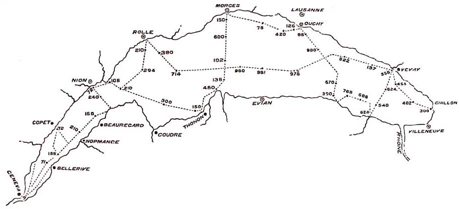
Lake of Geneva and Soundings.

FIG. 93.

Lake of Geneva

Old glacier of the Rhone, covering what is nowthe Lake of Geneva.

The shaded part represents the rock-basin beneath the  lake. The dark line the lake, showing its depts on a true scale. The light part above represents the Old Glacier of the Rhone. Figures, depth of the lake in feet.
[Alpine Lakes. 443]

southern slopes of the Oberland, and the northern drainage of all the southern Alps, from Mont Blanc to the Matterhorn, which looks down on the modern puny glacier of the Rhone. But where at its western end, near Geneva, the ice was thinner, there the pressure and grinding power were less, and the waste of the underlying rock was proportionately diminished. The result was, that a great hollow was scooped out, at least 984 feet deep as sounded by De la Beche, or about 1,000 feet as given by later measurements in the deepest part, without allowing for the moraine matter that, in later times, must have been left in the depths of the lake by the retreating glacier, or for the modern sediment that covers the bottom. At first it may be difficult to realise this theory and to appreciate the mode of action of the ice, but when we compare the depth with the length of the lake and the height and weight of the ice above, and reduce all to a true scale, as shown in fig. 92, it becomes evident that the depth of the rock-basin is comparatively quite insignificant.

I have elsewhere shown that the rock-bound lakes of Brienz and Thun had the same kind of origin. These were originally one lake, but are now separated by broad alluvial meadows. In like manner the Lakes of Lucerne, Zug, the Wallen See, Zurich, and Constance, all lie in rock-basins of erosion by glacier ice. The same is the case with many other Swiss lakes of minor note, and should anyone wish to see actual basins, visibly bordered by glaciated rocks, let him critically inspect the lakes of Sarnen and Lurigern on the route from Lucerne across the Brunig. The deep hollows in which the great Italian lakes lie on the south side of the Alps had a similar origin.
1

1 See Memoir by the Author, 'On the Glacial Origin of certain

[444 European and American Lakes.]

It may seem strange that I should take the Lake of Geneva as a special example, when the lakes of Llanberis, Llyn-llydaw, and Bala in Wales, Windermere in the Cumbrian region, Loch Doon in Ayrshire, Loch Katrine, or Loch Lomond, and many other lakes in the Highlands, would on a smaller scale do as well. But though it was in Wales that the first idea of the theory struck me, while mapping its moraines and ice-grooves in 1854, yet it was only after a critical examination of many of the lakes in and around the Alps, that in 1861 I ventured to assert that nearly all their basins were scooped out by the great glaciers of the icy period. I then first clearly saw its bearing as a veritable discovery in physical geography, affecting not Switzerland and Britain alone, but a large part of the habitable world.

If we examine the maps of the northern hemisphere generally, beginning at the equator, and going north, it is remarkable that, excepting lagoons, crater-lakes, and a few formed by subsidence in volcanic areas, we find very few important lakes in its southern regions, and these chiefly in Central Africa, where no traveller has yet tried to account for them. As we proceed northwards in America, in latitudes 38° and 40°, the lakes on the eastern half of the continent begin to increase, and soon become tolerably numerous. North of New York, towards the St. Lawrence, they become so numerous, that they appear on large maps to be scattered over the country in every direction, and beyond this to the west and north of Lake Superior and the St. Lawrence, the whole country is, so to speak, sown

Lakes,' &c. 'Jour. Geol. Soc.' 1862, vol. xviii. For the germ of the whole subject see also 'The Old Glaciers of Switzerland and North Wales,' 'Peaks, Passes, and Glaciers,' republished as a separate book 1860.

[Scandinavian and Welsh Lakes. 445]

broadcast with lakes large and small, and a vast number of the smaller ones are omitted partly for want of room, and partly because even now they are unknown to topo.. graphers. The whole of that area has been completely covered by ice, as the researches of geologists show.

Coming to this side of the Atlantic, and examining the Scandinavian chain on the east, where the slopes are less inclined than on the western flank, all round the Gulf of Finland, and the Swedish coast of the Baltic, the whole country is covered with lakes, many, if not all, of which lie in true rock-basins, a fact which I inferred in my memoir on lakes published in 1864, and which has since been proved by Mr. Amund Helland, of Christiania, in his late memoirs, a summary of which is given in his paper 'On the Ice-Fjords of North Greenland, and on the Formation of Fjords, Lakes, and Cirques in Norway and Greenland.' 
1 In Finland, according to Professor Nordenskiold, the lakes lie in a glaciated country, being chiefly dammed in by heaps of detrital matter called Osar.2 Go into North Wales where glaciers were once in every valley; there we have the lakes of Llanberis, once one, and 107 feet deep where deepest, of Cwellyn, Ogwen, Llyny-Ddinas, Llyn Gwynant, Llyn-llydaw (180 feet), Glaslyn, (114 feet), and all the lakes and tarns near Cape! Curig, and in the upper Corries, each lying in a true rock

1 'Journal of the Geological Society,' 1877, vol. xxiii. p. 142.

2 The Eskers of Ireland and the Kames of Scotland. These are common in the valley of the Clyde, especially near Lanark and Carstairs, where they form elongated irregular mounds of gravel which sometimes merge into true glacial detritus. They enclose lakes and peat-mosses, once lakes. They have been mapped and described by Professor Geikie. They occur in the grounds of Castle Kennedy near Stranraer, enclosing two beautiful lakes, and also in Northumberland, Lancashire, and Yorkshire.

[446 Cumberland Lakes.]

basin. All the lakes in Cumberland that I have examined (and of which I have seen soundings) lie in true rock-basins (unless, in some cases, a few of the smaller ones may be dammed up by mere moraines or other superficial detritus) ; and this has been confirmed by Mr. Ward in his various memoirs on the glaciation of Cumberland, published in the' Journal of the Geological Society.', I was also informed by the late Professor Jukes, and personally know, that the glacial origin of many of the celebrated lakes in Ireland, and of others unknown to fame is equally clear. Professor Hull also has confirmed the view that great numbers of the lakes in Ireland lie in veritable rock-basins, often crowded together in districts some of which I have not yet seen. Few or no parts of Britain have been more intensely glaciated than Ireland, and, indeed, all of these regions have been extremely abraded by glacier-ice.

In Scotland, in the southern hills, and in Kirkcudbrightshire and Ayrshire, there are many truly rock-bound lake-basins scooped out of the Silurian rocks of the Carrick Hills. If anyone wants a convincing proof let him go to Loch Doon, where at the outflow of the lake he may see the rocks perfectly moutonnée and well grooved, slipping under the water in a manner that unmistakably marks an ice-worn rocky barrier, while elsewhere all round the lake is circled by mountains, the highest of which is more than 2,800 feet in height. In the Shetlands and the Orkneys, in the Lewes and all the Western Islands, in Sutherland, Inverness-shire, Perthshire, Dumbartonshire, and the Mull of Cantyre, the country is, as it were, sown with lakes-a number of which I can testify by personal observation lie in true rock-basins.

Let anyone climb to the summit of Suilven in

[Scottish Lakes. 447]

Sutherland, which rises sharp and steep-sided above a broad, bare, undulating plateau of gneiss (p. 289) and let him count the lakes, large and small, seen from the top. In 1859, on one side alone I counted forty-two, and turning round to count those on the other sides, I thought-their name is legion! and gave it up. I cannot assert that each one is a rock-basin, but everyone that I visited, not there alone, but in other Highland areas, is so, and it is simply absurd to suppose that each tarn or larger lake was provided with a special area of subsidence wherein its water might lie, especially when many of such hollows lie in one broad plateau. As for tilting up the outlets of valleys, or the depression of their upper reaches, it would indeed require a remarkable series of tiltings to have produced the myriad lakes of Scotland, Sweden, and North America, and it would be difficult to give a reason why such unnumbered special tiltings should have been confined to areas the surfaces of which had all been subject to glaciation.

Rock-bound basins are, however, not confined to the land, for they are almost universal in the bottoms of fords, or, as they are called in Scotland, Salt-Water Lochs, which so largely intersect all coasts where glaciers are or have been.

All Scotchmen who know the west coast are familiar with these long, narrow, mountainous arms of the sea, which any person capable of a grain of thought at, once recognises as seaward continuations of inland valleys, which, it is well known, were, in Scotland and Norway, filled with glaciers. As far as I know, Professor James D. Dana, of Newhaven, U.S., was the first who distinctly stated that ' fiord-latitudes and drift-latitudes are the same.'1
In the term 'drift-latitudes' are

1 Manual of Geology,' 1863, p. 543.

[448 Fiords.]

included all those glacial influences that polished and grooved rocks and scattered erratic boulders.

Ever since exact Admiralty charts were published, it has been well known that our fords are generally shallower at their mouths than further up, and it is more than thirty years ago since Mr. Charles Darwin observed, that 'Tierra del Fuego may be described as a mountainous land, partly submerged in the sea, so that deep inlets and bays occupy the place where valleys should exist' ('Journal of a Naturalist'). He has also remarked that the fords are generally shallower towards their mouths than in the interior, at that time attributing this fact to the gathering of sediments on those exposed parts of the coast that are more subject to the abrading action of the sea than they are in the stiller interior reaches. In my memoir on Lakes, published in 1862, I stated of Scotland and Norway that the fords and lochs are the prolongation of valleys down which glaciers flowed, and each was itself filled with a glacier, and I attributed the origin of their deep interior basins to the grinding power of glacier-ice; and in 1865, in the 'Philosophical Magazine,' I compared their inner great depths to those of Loch Lomond, itself once a fiord and a true rock-bound basin; for, in among the group of beautiful islands, mere striated roches moutonnées, near the outflow of the Leven, the water is only from 8 to 17 fathoms deep, while opposite Ben Lomond it deepens to 89 fathoms, or 534 feet, and above Tarbet opposite Culness to 105 fathoms, or 630 feet. If the country were to sink 20 feet, the surface of Loch Lomond would be at the level of the sea, and a few feet of additional depression would again convert it into a fiord like Loch Long, Loch Fyne, or Loch Etive.

[Fiords. 449]

Though I have no doubt that many seaward extensions of land valleys, now fords, were once dry land valleys themselves, and that the deeper hollows in them were sometimes excavated when the whole stood above the level of the sea, yet this is not essential, for as has been observed by Mr. Amund Helland in his masterly papers (already quoted) on the Glaciation of Greenland, Norway, and Sweden, if a great glacier be sufficiently powerful to push onward, and grind for many miles along the bottom of a long fiord, the scooping out of rock-bound basins will be much the same as if its whole length were above the level of the sea.

I am not aware of any such fiords on the coast of England, though it may very well be that in Wales the Estuary of the Mawddach may be an old lake or rockbound fiord-basin now greatly silted up, for the frequent roches moutonnées opposite Barmouth, once islands, seems to indicate a rocky barrier there.

When, however, we go into Scotland, where the mountains are high and the valley ice-streams were thick, there is no lack of them there. From Loch Erriboll, with its ice-ground mountains and islets, fig. 94, to the Firth of Clyde there is not a fiord that is not deeper in its further recesses than at its mouth, a fact proved by the charts of the Admiralty.
1 It is needless here to enter into minute details, but I may mention that the small fiord of Loch Erriboll is 78 feet deep near its upper end, and much shallower at its mouth. Half way up, little Loch Broom has a depth of 342 feet, and at its mouth is nowhere deeper than from 60 to

1 For a recent account of this subject see 'The Great Ice Age, by James Geikie, LL.D., F.R.S., in which, on very clear maps, he shows soundings both of inland fords, and sea rock-basins near the British coasts.

[450 Fiords.]

FIG. 94.
Loch Erriboll
Loch Erriboll, Sutherland.

156 feet. Loch Fyne, about eight miles below Inverary, is 414 feet deep, and is very much shallower 15 miles further down, while in Loch Etive, near Oban, the whole theory is brought prominently before the eye, as shown in the accompanying picture, fig. 95.

The mouth of this sea loch or fiord at Connel. Ferry is so narrow, that it seems as if a stone might almost be thrown across, but further up it spreads into a noble sheet of water, and its length is about 20 miles, and its greatest depth 456 feet. When the tide is up, on a quiet day, all is still and unruffled from end to end; but as the tide falls the water gets troubled across the mouth of the fiord, two rocky islets begin to appear, and by-and-by, standing on the roche moutonnée in the foreground, it becomes plain that a rocky barrier traverses the fiord from side to side, over which the outflowing sea falls with a roar that may be heard for a mile or more.
1 If the region were raised for a few feet, Loch Etive, by influx of rivers, would by degrees become changed into a freshwater lake, like its neighbouring tributary rock-bound basin Loch Awe, which is 306 feet deep where deepest. Here then is what may be called a demonstration of the glacial origin of many rock-bound fiord basins, unless we can persuade ourselves to believe that all the great fiords of Scotland, Norway, Greenland, and North and South America, were by some special operation upheaved at their mouths, no matter how the inlets trend, so that some day when these countries may be further elevated, the fiords shall all be converted into inland rock-bound freshwater lakes! 2

1 Coruisk in Skye is another case in point on a smaller scale.
2 The Lakes of Maggiore and Como were once fords. Long

[452 Fiords.]
FIG. 95.
Mouth of Loch Etive
Mouth of Loch Etive, Connel Ferry.


[Greenland. 453]

This point is clear, that most of our country, as in Greenland and Victoria Land now, was in the icy period ground by a heavy weight of slowly moving and long enduring glacier-ice, which I firmly believe was the scooping power that originated most of the lake scenery of our country. I go further, for in ice-worn rocky regions, both north and south of the equator, the farther north or the farther south we go the more do lakes increase in number, and I am convinced, that this fact is not a mere accidental coincidence, but is one of the strongest proofs of the former existence of that widespread coating of glacier-ice that in old times inoulded the face of so much of both hemispheres. The day has been when Greenland was a mild and fertile country,1 and should such an episode return, its land-surface will be varied by a prodigious number of lakes, and should its fords emerge, its splendid highland valleys will show many a long stretch of fresh water dotted with islands, like some of the lakes of Sweden, of Loch Lomond, and others in Scotland, or like Lake Champlain in North America.

This full theory, brought out in March, and published in August 1862, of the origin of so many lakes in the northern hemisphere, wherever there have been either widespread continental or even isolated mountain glaciers, was on the whole received with disfavour, or 'faint praise,' in England and Switzerland when first produced, and it fared but little better in the north of Italy, where, however, it was then allowed that it 'deserved the gravest attention,' and its general principles have since been accepted by Gastaldi. Now

before this was discovered I had proved them to be rock-bound glacier lake-basins.
1 In Miocene times.

[454 Lakes.]

it finds its way into geological manuals, and many monographs, reports, and memoirs; in some of which it has been stated that it must in the long run be accepted as the origin of those rock-basins of the northern hemisphere that are occupied by lakes.
1

Finally, if I were to classify lakes directly and indirectly produced by glacial action, it would be as follows—the first named being most and the last least numerous: 1st. True rock-basins scooped by glacier-ice out of the solid rocks. 2nd. Lake hollows due to irregular accumulation of moraine-matter on broad flattish surfaces, among which in many districts may be

1 See Professor Geikie, 'Phenomena of the Glacial Drift of Scotland;' Sir William Logan, 'Report on the Geology of Canada,' 1863, where he states that the great North American lake-basins are depressions, not of geological structure, but of denudation; and the grooves on the surfaces of the rocks which descend under their waters appear to point to glacial action as one of the causes which have produced these depressions.' Also Dr. Newberry, in the 'American Annual of Scientific Discovery,' for 1863, and in other publications. Following my view, he allows that glacier-ice excavated all the great lakes, from Ontario to Lake Superior, excepting Lake Superior, an exception for which I see no necessity. See also reports by Dr. Julius Haast on the Geology of New Zealand; and the writings of Dr. Hector and Captain Hutton on the same region; Professor Geikie, 'The Scenery of Scotland viewed in connection with its Physical Geology,' 1867, and 'The Student's Manual of Geology,' by the late Professor Jukes, third edition, edited by Professor G-eikie. Mr. Jukes strongly advocated this theory in papers in the 'Reader,' in a long controversy with the late Dr. Falconer. See also 'The Great Ice Age,' by James Geikie, F.R.S., both for lakes and fords, and last, not least, the letter of Signor Gastaldi in the 'Journal of the Geological Society' to Sir Charles Lyell, 1873, vol. xxix., in which he says, 'I have given you summarily the reasons which have converted me to Mr. Ramsay's theory.' I could quote other authors on the same side of the question, and I am more than content with the rapid progress it has made. Sir Charles Lyell gives a qualified assent. in his 'Student's Elements of Geology,' 1871.

[Lakes. 455]

included those dammed in by Eskers or Kames, well known on a large scale in Finland, and good examples of which, on a smaller scale, may be seen at Carstairs, and in the beautiful grounds of Castle Kennedy near Stranraer. Many of these lakes since their formation have got filled with alluvial detritus, and are now peat mosses. There are also many small hollows formed in original irregular accumulations of the boulder-clays of Northumberland and Durham, now filled with laminated clays, sands, and bearing fresh-water shells and plant-remains, and some of these shallow lakes still exist as such. 3rd. Moraine-dammed lakes, which I think on the whole are scarce, for many that appear to be so are in reality more than half rock-basins, or only dammed up by moraine-matter for a part of their depth.

Of lakes in Britain, formed by sinking of the ground, I know of none, save a few pools of water formed by the infalling of New Red Marl above salt-mines and brine-pits.