[496]
CHAPTER XXX.
ORIGIN OF RIVER VALLEYS—THEIR RELATION TO TABLE-LANDS—ESCARPMENTS CUT THROUGH BY RIVERS—GEOLOGICAL DATES OF DIFFERENT RIVER-VALLEYS—THE SEVERN, THE AVON, THE THAMES, THE
FROME, AND THE SOLENT—TRIBUTARIES OF THE WASH AND THE HUMBER—THE EDEN AND THE
WESTERN-FLOWING RIVERS—SCOTLAND.
IT is difficult, or almost impossible, even approximately to settle precisely what are the
geological dates of the valleys through which many rivers run; or, in other words, when they
first began to be scooped out, and through what various periods their excavation was
intermittently or continuously carried on. No one has yet thoroughly analysed this subject, and
only of late years have 1 begun clearly to see my way into it. Nevertheless a good deal has been
done even now, and a great deal more will be accomplished when, with sufficient data, the whole
subject may come to be investigated. In Wales, for example, there are vast numbers of rivers
and brooks, small and large, and when we examine the relation of these streams to the present
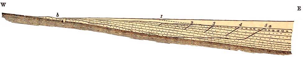
surface of the country, we often find it very remarkable. Fig. 97 is a diagram representing no
particular section, but simply the general nature of the sections across the Lower Silurian
strata of Cardiganshire, as shown by myself in a paper given to the British
[Plains of Marine Denudation. 497]
Association at Oxford in 1847. The dark-coloured
part represents the form of the country given
in the original sections on a scale of six inches to a mile horizontally and vertically. The strata
of this area, and, indeed, of much of South Wales, are exceedingly contorted. The level of the sea
is represented by the lower line; and if we take a straight-edge, and place it on the topmost part
of the highest hill, and incline it gently seaward, it touches the top of each hill in succession, in
the manner shown by the line b b. This line is as near as can be straight, and, on the average,
has an inclination of from one to one and a half degrees; and it is a curious circumstance that in
the original line of sections there were no peaks rising above that line—they barely touched it
and no more. It occurred to me when 1 first observed this circumstance that, at a period of
geological history of unknown date, perhaps older than the beginning of the deposition of the
Permian and New Red Sandstones, this inclined line that touches the hill-tops must have
represented a great plain of marine denudation.
FIG. 97

Atmospheric degradation, aided by sea waves on
the cliffs by the shore, are the only powers I know that can denude a country so as to shave it
across, and make a plane surface either horizontal or slightly inclined. If a country be
sinking very gradually, and the rate of waste by all causes be proportionate to the rate of
sinking, this will greatly assist in the production of the phenomena we are now considering: and
a little reflection will show,
[498 Plains of Marine Denudation.]
that the result would be an inclined plane like that of the straight line b b in the diagram. Let
South Wales be such a country: then when that country was again raised out of the water, the
streams made by its drainage immediately began to scoop out valleys; and though some
inequalities of contour forming mere bays may have been begun by marine denudation during
emergence, yet in the main I believe that the inequalities below the line b b have been made by
the influence of rain and running water. Hence the number of deep valleys, many of them
steepsided, that diversify Wales, all the way from the Towey in Caermarthenshire to the slaty
hills near the southern flanks of Cader Idris and the Arans.
On ascending to the upper heights, indeed, anywhere between the Vale of Towey and Cardigan
Bay, it is impossible not to be struck with the average uniformity of elevation of the flat-topped
hills that form a principal feature of the country. The country already described as seen from
Ramsey Island is part of this plain,1 and much further north let anyone ascend Aran Mowddy or
Cader Idris in Merionethshire, and look south and south-east. From thence he will behold, as far
as the eye can reach, a wide extent of flat-topped hills, which form the relics of a vast
tableland, now intersected by numerous rivers, which, in the long lapse of untold ages, have
scooped out unnumbered labyrinthine valleys eastward into Montgomeryshire, and far south
into Cardiganshire. Between the rivers Towey and Teifi, and in other areas, these hills, in fact,
form the relics of a great plain or tableland in which the valleys have been scooped out; and in
the case of the country represented in fig. 97, 'the higher land, as it now exists, is
1 See p. 487.
[Marine Denudation. Escarpments. 499]
only the relic of an average general gentle slope, represented by the straight line (b b) drawn
from the inland heights towards the sea.1 Mr. Jukes applied and extended the scope of the same
kind of reasoning to the south of Ireland, with great success. In various parts of Europe, notably
in those regions that have been longest above the water-on the banks of the Moselle and of the
Rhine, and in the great coalfield west of the Appalachian chain in North America-we find
unnumbered valleys intersecting tablelands, of a form that leads us to believe that they also
have been made by the long-continued action of atmospheric waste and running waters; and I
believe that the valleys of South Wales have been formed in the same way, and in their origin
are even often of latest palæozoic dates.
Nothing is more remarkable in the history of rivers than the circumstance that very frequently
they run straight through bold escarpments, which at first sight we might suppose ought to have
barred the course of the streams.2 The Wye in South Wales, for example, runs through a bold
escarpment of Old Red Sandstone hills; and the same is the case with the Usk.
For long it was customary to attribute such breaches in escarpments and indeed valleys in
general, to disturbances and fractures of the strata, producing a wide separation, and actually
making hills. But when we realise that thousands of feet of strata have often been removed by
denudation since the great disturbances of the Welsh strata took place, it becomes clear that the
present valleys are in no way immediately connected with them; for even if there be
dislocations or faults
1 Reports, British Association, p. 66, 1847.
2 This has already been alluded to in the case of the rivers of the
Wealden, pp. 108-119.
[500 Valleys and Dislocations.]
in some of the valleys, these faults when formed were, as far as regards the present surface,
thousands of feet deep in the earth. All they could do might have been
FIG. 98.
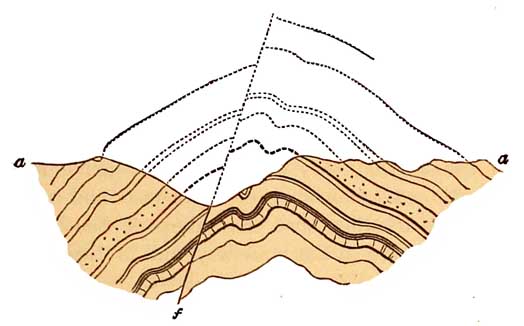
a Present surface of the ground.
The dotted lines show the continuation of an anticlinal curve broken by a fault f.
The dotted lines above the surface a a represent a certain amount of strata removed by
denudation.
to establish lines of weakness along which subsequent denudation may have excavated valleys.
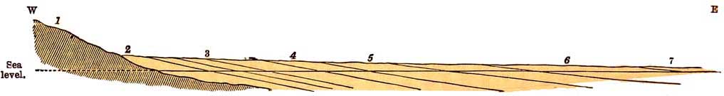
The real explanation of such cases as those of the Wye and the Usk is this. At some period, now
uncertain, the beds of the Old Red Sandstone, well seen in the escarpment of the Beacons of
Brecon, a, and the Caermarthen Fans, once spread much farther westward, forming a great
plain, b b (fig. 99), the result of earlier denudations. This plain sloped gently eastward, and the
dotted line shows the general state of old outcrops of the strata. The river then ran over ground
perhaps even higher than the tops of the hills of the present escarpment, and by degrees it cut
itself a
[The Wye and the Usk. 501]
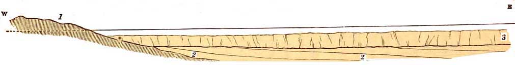
FIG. 99.
Diagram showing the mode of formation of the escarpment of
the Beacons of Brecon and the Caermarthen Fans, South Wales.
bb, Original plain sloping gently eastward.
1, 2, 3, 4, 5 successive escarpments.
[502 Escarpments and Rivers.]
channel approximately in its present course, but varied and widened by subsequent river
action; and, as it cut out that valley, the escarpment, by the influence of rain and other
atmospheric causes, gradually receded to the points marked 1, 2, 3, 4, 5, and a, the last being
the present escarpment. For all observation tells us that escarpments of a certain kind work
back in this way, that is to say, in the direction of the dip of the strata.
One reason of this is, that escarpments often partly consist of hard beds lying on softer strata.
The softer strata are first more easily worn away along the line of strike, and thus an
escarpment begins to be formed. Once established, the weather acting on the joints and other
fissures in the rocks, takes more effect on the steep slope of the scarp than on the gentle slope
that is inclined away from the scarp. The loosened detritus on the steeper slope slips readily
downward, and is easily removed by floods of rain; and thus the escarpment constantly recedes
in a given direction, while on the opposite gentle slope, the loosened detritus, smaller in
amount, travels so slowly that it rather tends to block the way against further waste. In this
way we can explain how the Wye and the Usk break through the Old Red Sandstone and find their
way to the estuary of the Severn; why the Severn itself breaks through the Upper Silurian
escarpment of Wenlock Edge; why certain other rivers—such as the Dee in Wales, and the
Derwent in Cumberland—cut through escarpments of Carboniferous Limestone; and how, indeed,
the same kind of phenomena are everywhere prevalent under similar circumstances. Of this I
shall say more when I come to treat of the Oolitic and Cretaceous escarpments.
But when we have to consider the origin of some of
[The Severn. 503]
the larger river valleys, there is a great deal that is difficult to account for. One thing is
certain, that before the Glacial epoch the greater contours of the country were much the same as
they are now. The mountains of Scotland, Wales, and of Cumberland, and the great Pennine
chain, existed then, somewhat different in outline, and yet the same essentially; the central
plains of England were plains then, and the escarpments of the Chalk and Oolites existed before
the Glacial period. All that the ice did was to modify the surface by degradation, to smooth its
asperities by rounding and polishing them, to deepen valleys where glaciers flowed, and to
scatter quantities of moraine-detritus, partly in the shape of boulder-clay and of marine
boulder beds, and sands and gravels, over the plains that form the east of England, and the Lias
and New Red Sandstone in the middle.
If we examine the valley of the Severn from Bristol northwards through Coalbrook Dale, we find
that for a large part of its course the river runs down a broad valley, between the old Palaeozoic
hills and the escarpment formed by the tableland of the Cotswold Hills which are highest in the
neighbourhood of Cheltenham. That valley certainly existed before the Glacial epoch, because we
find boulders and boulder-drift far down towards Tewkesbury; and therefore, I believe that
before the Glacial epoch this part of the Severn ran very much in the same course that it does at
present. During part of the Glacial epoch the country sank beneath the sea, and Plinlimmon
itself, where the river rises, was perhaps buried in part beneath the waters. When the country
again emerged, the old system of river-drainage in that area was resumed; and the Severn,
following in the main its old course, cut a
[504 Early Physical Changes.]
channel for itself through the boulder-clay that partially
blocked up the original valley in which it ran. When
that original valley was formed through which the older Severn ran is the point that I shall now
attempt to discover. This subject is intimately connected with the origin and geological dates of
the channels of many of the other large rivers of England, most of which, unlike the Severn,
flow eastward to the English Channel and the German Ocean.
I must begin the subject by a rapid summary of certain physical changes that affected the
English Secondary and Eocene strata long before he Severn, after leaving the mountains of
Wales, took its present southern and south-western course along the eastern side of the
Pa1aozoic rocks that border that old land.
About the close of the Oolitic epoch the Oolitic formations were raised above the sea, and
remained a long time out of water; and, during that period, those atmospheric influences that
produced the sediment of the great Purbeck and Wealden delta were slowly wearing away and
lowering the land, and reducing it to the state of a broad undulating plain. At this time the Oolitic
strata still abutted on the mountain country now forming Wales and parts of the adjacent
counties. They also completely covered the Mendip Hills, and passed westward as far as the
mountains of Devon passing out between Wales and Devonshire through what is now the Bristol
Channel. The whole of the middle of England was likewise covered by the same deposits,
overlying the rocks that now form the plains of Shropshire, Cheshire, Lancashire, and the
adjoining areas, so that the Lias and Oolites passed out to the area now occupied by the Irish Sea,
over and beyond the present estuaries of the Dee and the Mersey,
[505]
FIG. 100.
 General Arrangement of the Lower Secondary Formations
before the Deposition of the Upper Secondary Strata.
1. Disturbed and hilly Silurian Old Red and Carboniferous strata.
2. New Red beds.
3. Lower Lias.
4. Marlstone and Upper Lias.
5. Lower Oolites.
6. Middle Oolites
7. Upper Oolites and Purbeck beds.
[506 Cretaceous Overlap.]
which lie between North Wales and the hilly ground of Lancashire, formed of previously
disturbed Carboniferous rocks. In brief, most of the present mountainous and hilly lands of the
mainland of Britain were mountainous and hilly then, and must have been much higher than
now, considering how much they have since suffered by denudation.
At this period, south of the Derbyshire hills, and through Shropshire and Cheshire, the
Secondary rocks lay somewhat flatly; while in the more southern and eastern areas they were
tilted up to the west, so as to give them a low eastern dip. The general arrangement of the strata
would then be somewhat as in fig. 100.
The submersion of this low lying area brought the deposition of the Wealden strata to a close,
and the Cretaceous formations were deposited above the Wealden and Oolitic strata, so that a
great unconformable overlap of Cretaceous strata took place across the successive outcrops of
the Oolitic and older Secondary formations. (See fig. 101.)
The same kind of overlapping of the Cretaceous on the Oolitic formations, took place at the same
time in the country north and south of the present estuary of the Humber, the proof of which is
well seen in the unconformity of the Cretaceous rocks on part of the Oolites and Lias of
Lincolnshire and Yorkshire.
At this time, the mountains of Wales, and other hilly regions made of Pa1aozoic rocks, must
have been lower than they were during the Oolitic epochs; partly by the effect of long-continued
waste due to atmospheric causes, but much more because of gradual and greatly increased
submergence during the time that the Chalk was being deposited. It is even possible that
[507]
FIG. 101.
Early Overlap of the Cretaceous Strata on the Lower Secondary Formations.
1. Disturbed hilly land, as in fig. 34.
2. New Red Liassic and Oolitic strata, &c.
3. Cretaceous
strata lying unconformably on and overlapping the denuded edges of No. 2, and at * abutting on
the half-submerged mountains of Wales.
[508 Miocene Continent.]
during the Upper Cretaceous period Wales sunk almost entirely beneath the sea.
I omit any detailed mention of the phenomena connected with the depositions of the freshwater
and marine Eocene strata because at present this subject is not essential to my argument.
The Miocene period of old Europe was essentially a continental one. Important disturbances of
strata brought it to a close, at all events physically, in what is now the centre of Europe; and the
formations partly formed in the great fresh-water lakes that lay at the bases of the older Alps
were, after consolidation, heaved up to form new mountains along the flanks of the ancient
range; and all the length of the Jura, and far beyond to the north-east, was elevated by
disturbance of the Jurassic, Cretaceous, and Miocene strata. The broad valley of the lowlands of
Switzerland began then to be established, long afterwards to be overspread by the huge glaciers
that abutted on the Jura, deepened the valleys, and scooped out all the rock-bound lakes.
One marked effect of this extremely important elevation, after Miocene times, of so much of the
centre of Europe was, that the flat, or nearly flat-lying Secondary formations that now form
great part of France and England (then united), were so far affected by the renewed upheaval of
the Alps and Jura that they were to a great extent tilted, at low angles, to the north-west. That
circumstance gave the initial northwesterly direction to the flow of 80 many of the existing
rivers of France, and led them to excavate the valleys in which they run, including the upper
tributaries of the Loire and Seine, the Seine itself, the Marne, the Oise, and many more of
smaller size; and
[Origin of the Severn Valley. 509]
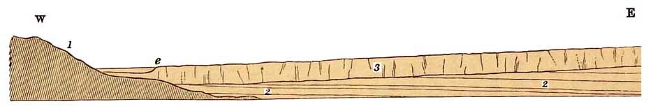
FIG. 102.
Post-Miocene Westerly Dip of the Cretaceous Strata of England.
1. Old Wales.
2. Oolitic strata, &c.
3. Chalk, &c. The surface of the Chalk slopes
gently from east to west.
[510 Severn and Avon, Tewkesbury.]
my surmise is, that this same westerly and north-westerly tilting of the Chalk of England formed a
gentle slope towards the mountains of Wales, as shown in fig. 102, and the rivers of the period
of the middle and south of England at that time flowed westerly. This first induced the Severn to
take a southern course between the hilly land of Wales and Herefordshire and the long slope of
Chalk then rising to the east. Aided by the tributary streams of Herefordshire, it began to cut a
valley towards what afterwards became the Bristol Channel, and established the beginning of the
escarpment of the Chalk, e, fig. 102, which has since gradually receded, chiefly by atmospheric
waste, so far to the east. If this be so, then the origin of the valley of the Severn between e and 1
is of immediate postMiocene date, and is one of the oldest in the lowlands of England.1
The course of the Avon, which is a tributary of the Severn, and joins it at Tewkesbury, is, I
believe, of later date than the latter river. It now rises at the base of the escarpment of the
Oolitic rocks east of Rugby, and gradually established and increased the length of its channel in
the low grounds now formed of Lower Lias and New Red Marl as that escarpment retired
eastward by virtue of that law of waste which causes all inland escarpments to retire away from
the steep slope and in the direction of the dip of the strata.
If the general slope of the surface of the Chalk of this part of England had been easterly instead
of westerly at the post-Miocene date alluded to, then the initial course of the Severn would also
have been easterly, like
1 Many of the valleys of Wales must be very much older.
[The Avon, Bristol. 511]
that of the Thames and the rivers that flow into the Wash and the Humber.
One of the best known rivers that enters the estuary of the Severn is the other Avon, which
flows through Bath and Bristol. Its physical history, on a small scale almost precisely
resembles that of the Rhine between Basle and Bonn.1
West of Bristol there is a high plateau of Carboniferous Limestone, the flat top of which attains
a height of nearly 400 feet above the level of the sea. Through a deep narrow gorge in this
limestone (fig. 103) the river flows, between Clifton and Durdham Downs on the east and Leigh
Wood on the west, north-west of which it enters the low grounds and finds its way to the estuary
of the Severn at King's Road. Above Bristol, north and south of the river, the country consists of
a number of isolated flat-topped hills, of which Dundry Hill and the Mendips form conspicuous
members, while in the neighbourhood of Bath, Lansdown, Charmy Down, Odd Down all the minor
Oolitic plateaux now form portions of what was once a continuous broad tableland with minor
undulations. In these regions the Avon takes its rise, swelled by many north-flowing
tributaries, one of which, the Chew, rises on the north flank of the Mendip Hills. North of Bath,
several minor streams flow into the Avon through beautiful valleys which have been scooped out
of the Oolitic plateau, while the Boyd, the Siston, and the Frome pass through the soft undulating
grounds of Lias, New Red Marl, and Coal-measures that lie west of the bold Oolitic escarpment
between Bath and Wotton-under-edge. Some of these streams rise at
1 'On the Physical History of the Rhine,' 'Journ. Geol. Society,' 1874, A. C. Ramsay.
[512 The Avon.]
heights approximately as high as the summit level of the limestone gorge through which the
Avon flows below Bristol.
The vulgar notion respecting the Avon and its gorge is, that before that ravine was formed all
the low ground through which the river and its tributaries flow was a large lake, that 'a
convulsion of nature' suddenly
Gorge of the Avon at Clifton, Bristol, looking down the river.
rent the rocks asunder and formed the gorge through which the river afterwards flowed, and so
drained the hypothetical lake. It is scarcely necessary to add, that had there been a large lake in
that area, we might expect to find lacustrine deposits and organisms in some parts of these
valleys, but none exist.
The true explanation is, that in some late tertiary period of geological history, the surface of
the country on either side of the river above the gorge formed a
[The Thames. 513]
great plain, somewhat higher than the summit level of the Carboniferous Limestone plateau.
This plain being slightly inclined to the west at the time the Severn was scooping out its valley,
as I have already explained at p. 508, the ancient Avon flowed over the top of the plateau of
Clifton and Durdham Downs, through a minor inequality of the surface, and, as rivers do, it
steadily worked at the deepening of its own channel. As it did this, so in like proportion the
river and its tributaries in the upper part of their courses gradually wasted and lowered the
hill-sides and valleys through which they flowed, being aided by rains and snows and all the
ordinary agents of atmospheric denudation; and thus it happens, that what was once a high
slightlyinclined tableland, has been converted partly into flattopped fragments of a high plain,
and partly into undulating hills and vales; while in the great Oolitic plateau, that stretches
eastward as far as the Chalk escarpment, we have still remaining a large tract of the ancient
plain, with this difference, that the average gentle slope of its surface is now east instead of
west.
This naturally leads to the question, Why is it that the Thames, and some other rivers that flow
through the Oolites and Chalk, run eastward? The answer seems to be, that after the original
valley of the Severn was well established by its river, a new disturbance of the whole country
took place, by which the Cretaceous and other strata were tilted eastward, not suddenly, but by
degrees, and thus a second slope was given to the Chalk and Eocene strata, in a direction opposite
to the dip, that originally led to the scooping out of the present valley of the Severn. This dip lay
east of the comparatively newly-formed escarpment of the Chalk indicated by the dark line in
fig. 102 marked e. The
[514 The Thames.]
present Chalk escarpment, in its beginning, is thus of older date than the Oolitic escarpment
(fig. 57, p. 304), but it would be hard to prove this, except on the hypothesis I have stated.
When this slope of the Chalk and the overlying Eocene strata was established, the water that
fell on the long inclined plain east of the escarpment of the Chalk necessarily flowed eastward,
and the Thames, in its beginning, flowed from end to end entirely over Chalk and Eocene strata.
The river was larger then than now, for I am inclined to believe, that in these early times of its
history, the south of England was joined to France, the Straits of Dover had no existence, and the
eastern part of the Thames as a river, not as a mere estuary, ran far across land now destroyed,
perhaps directly to join an exterision of the north flowing river which we now call the Rhine.
At its upper end, west of its present sources, the Thames was longer by about as much probably
as the distance between the well-known escarpment of the Cotswold Hills and the course of the
Severn as it now runs, for the original escarpment of the Chalk must have directly overlooked
the early valley of the Severn, which was then much narrower than now (see p. 509). But by
processes of waste identical with those that formed the escarpment of the Wealden (figs. 71,
72, 73, pp. 337-343), the Chalk escarpment gradually receded eastward, and as it did this the
valley of the Severn widened, and the area of the drainage of the Thames was contracted.
By-and-by the outcropping edges of the Oolitic strata becoming exposed, a second and later
escarpment began to be formed, while the valley of the Severn gradually deepened; but the
escarpment of the Chalk being more
[The Thames. 515]
easily wasted than that of the Oolite, its recession eastward was more rapid, and this process
having gone on from that day to this, the two escarpments in the region across which the Thames
runs are far distant from each other.
All this time the Thames was cutting a valley for itself in the Chalk, and by-and-by, when the
escarpment had receded to a certain point, its base became in part lower than the edge of the
Oolitic escarpment that then, as now, overlooked the valley of the Severn, only at that time the
valley was narrower. While this point was being gradually reached, the Thames by degrees was
joined by the growing tributary waters that drained part of the surface of the eastward slope of ihe Oolitic strata, the western
escarpment of which was still receding; and thus was brought about, what at first sight seems
the unnatural breaking of the river through the high escarpment of Chalk between Wallingford
and Reading.
From the foregoing remarks it will be understood why the sources of the Thames, the Seven
Springs and others, rise so close to the great escarpment of the Inferior Oolite, east of
Gloucester and Cheltenham. But just as in times long gone, the sources of the Thames once rose
westward of the Seven Springs, so well known on the Cotswolds, so the sources of the river now,
are not more stationary than those that preceded. The escarpments, both of Chalk and Oolite, are
still slowly changing and receding eastward; and as that of the Oolite recedes the area of drainage
will diminish and the Thames decrease in volume. This is a geological fact, however distant it
may appear to persons unaccustomed to deal with geological time
[516 The Frome.]
A change in the story of an old river, even more striking than that of the Thames, has taken
place in the history of what was once an important stream further south. Before the formation
of the Straits of Dover, the solid land of England, formed of Cretaceous and Eocene strata,
extended far south into what is now the English Channel. The Isle of Wight still exists as an
outlying fragment of that land. At that time the Nine Barrow Chalk Downs, north of Weymouth
Bay and Purbeck, were directly joined as a continuous ridge with the Downs that cross the Isle
of Wight from the Needles to Culver Cliff. Old Harry and his Wife, off the end of Nine Barrow
Downs, and the Needles, off the Isle of Wight, are small outlying relics, left by the denudation of
the long range of Downs that once joined the Isle of Wight to the so-called Isle of Purbeck, and of
the land that lay still farther south of Portland Bill the Isle of Wight and Beachy Head.
North of this old land, the
Frome, which rises in the Cretaceous hills east of Beaminster, still runs,
and, much diminished, discharges its waters into Poole Harbour. But in older
times the Solent formed part of its valley, where, swollen by its affluents,
the Stour, the Avon, the Test, and the Itchin, it must have formed a large
river, which, by great subsequent denudations and changes in the level of
the land, has resulted in the synclinal hollow through which the semi.estuarine
waters of the Solent now flow.1
The same kind of argument that has been applied
1
See Mr. T. Codrington 'On the Superficial Deposits of the South of Hampshire and the Isle of
Wight.' Quart. Jour. Geol. Soc. 1870, vol. xxvi., p. 528, and Mr. John Evans, 'Stone
Implements,' Chap. XXV.
[The Trent. 517]
to the Thames is equally applicable to the Ouse, the Nen, the Welland, the Glen, and the Witham,
rivers flowing into the Wash, all of which rise either on or close to the escarpment of the
Oolites, between the country near Buckingham and that east of Grantham, which rocks were once
covered by the Chalk.
With minor differences, the same general theory equally applies to all the rivers that run into
the Humber. I believe the early course of the Trent was established at a time when, to say the
least, the Lias and Oolites overspread all the undulating plains of New Red Marl and Sandstone of
the centre of England, spreading west to what is now the sea, beyond the estuaries of the Mersey
and the Dee. A high-lying antielinal line threw off these strata, with low dips, to the east and
west; and, after much denudation, the large outlier of Lias between Market Drayton and
Whitchurch in Shropshire, is one of the western results. Down the eastern slopes the Trent
began to run across an inclined plain of Oolitic strata. Through long ages of waste and decay the
Lias and Oolites have been washed away from these midland districts, and the long escarpments
formed of these strata lie well to the east, overlooking the broad valley of New Red Marl through
which the Trent flows.
The most important affluent of the Trent is the Derwent, a tributary of which is the Wye of
Derbyshire. The geological history of the Wye is very instructive. It runs right across part of
the central watershed of England, formed by the great boss of the Carboniferous Limestone of
Derbyshire. This course, at first sight seems so unnatural, that the late Mr. Hopkins of
Cambridge stated that it was caused by two fractures in the strata, running parallel to the
winding course of
[518 The Wye, Derbyshire.]
the river.1 There are no fractures there of any importance. The true explanation is as follows:
At an old period of the physical history of the country, the valley north and west of Buxton had
no existence, and the land there actually stood higher than the tops of the limestone hills to the
east. An inclined 'plain of marine denudation,' stretched eastwards, and gave an initial direction
to the drainage of the country. The river began to cut a channel through the limestone rocks; and
as it deepened and formed a gorge, the soft Carboniferous shales in which the river rose, were
also worn away by atmospheric action, and streams from the north and west began to run into
the Wye. By the power of running water, those valleys were deepened simultaneously and
proportionately to their distance from the sources of the river; and the farther the Wye flowed,
the more was its volume increased by the aid of tributary streams and springs Thus it happens
that the Wye seems to the uninitiated unnaturally to break across a boss of hills, which,
however, were once a mere slightly undulating unbroken plain of limestone. There is no
breakage of the rocks, and nothing violent in the matter. It was and is, a simple case of the
wearing action of running water cutting a channel for itself from higher to lower levels, till,
where Rowsley now stands, it joined the Derwent, which flows in a long north and south valley
scooped
1 'On the Stratification of the Limestone District of Derbyshire,' by W. Hopkins, M.A., &c. For
private circulation. 1834. In p. 7 he says, 'When two longitudinal faults, ranging parallel, are
not, very distant from each other, they sometimes form a longitudinal valley, of which the
valley of the Wye is a splendid instance. In such cases, however, it is curious that the faults do
not generally coincide with the steep sides of the valley, but are distant from them by perhaps
from 50 to 200 or 300 yards.'
[The Humber. 519]
by itself, chiefly in comparatively soft Yoredale shales between the high-terraced hard
moorland scarps of Millstone Grit, and the still harder grassy slopes of the Carboniferous
Limestone.
When we come to the other rivers that enter the Humber north and west of the Trent, the case
is more puzzling. The Oolites in that region were extensively denuded before the deposition of
the Chalk; so that between Market Weighton and Kirkby-under-dale in Yorkshire, the Chalk is
seen to overlap unconformably the Oolitic strata, and to rest directly on the Lower Lias, which
there, as far as it is exposed, is very thin. The Chalk, therefore, overspread all these strata to
the west, and lay directly on the New Red beds of the Vale of York, till, overlapping these, it
probably intruded on the Carboniferous strata of the Yorkshire hills farther west. At this time
the Oolites of the northern moorlands of Yorkshire seem also to have spread westward till they
also encroached on the Carboniferous slopes, the denuded remains of which now rise above the
beautiful valleys of Yoredale and Swaledale, the whole, both Carboniferous and Secondary, strata
having gentle eastern and south-eastern dips. These dips gave the rivers their initial tendency
to flow south-east and east; and thus it was that the Wharfe, the Ouse, and the Swale, cutting
their own channels, formed a way to what is now the estuary of the Humber, while the
escarpments of the Chalk and Oolite were gradually receding eastward to their present
temporary positions.
That the Oolitic strata spread northward beyond their present scarped edges is quite certain; but
whether or not they extended far enough north to cover the whole of the Durham and
Northumberland coalfield I am unable to say. Whether they did so or not
[520 The Tees, Wear, Tyne, &c.]
does not materially affect the next question to be considered; for if they did spread over part of
these Carboniferous strata, they must have thinned away to a feather edge in times long before
the Oolitic escarpment began to be formed.
Taken as a whole, from the
great escarpment of Carboniferous Limestone that overlooks the Vale of Eden
on the east, all the Carboniferous strata from thence to the German Ocean
have a gentle eastern dip; so gentle, indeed, that, on Mallerstang and other
high hills over]ooking the Vale of Eden, outlying patches of Millstone Grit,
still remain to tell that once the whole of the Coalmeasures spread across
the country as far as the edge of the Vale, and even far beyond in pre-Permian
times, for the Carboniferous Limestone on both sides of the Vale of Eden,
now broken by a fault, was once continuous, and the Whitehaven coalfield
was then united to that of Northumberland. These gentle eastern and south-eastern
dips, caused by upheaval of the strata on the west and north-west, gave the
initial tendency of all the rivers of the region to flow east and south-east.
Thus it happens that the Tees, the Wear, the Derwent, the Tyne, the Blyth,
the Coquet, and the Alne, have found their way to the German Ocean, cutting
and deepening their valleys as they ran, the sides of which, widened by time
and subaerial degradation, now often rise high above the rivers in the regions
west of the Coal-measures, in a succession of terraces of limestone bands,
tier above tier, as it were in Titanic steps, till on the tops of the hills
we reach the Millstone Grit itself.
I now turn to the western-flowing rivers, about which there is far less to be said.
First, the Eden :—This river flows along the whole
[The Eden 521]
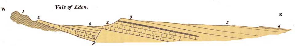
FIG. 104.
Section from the Cumbrian Mountains across the
Vale of Eden to the Northumberland Coalfield.
1. Silurian flocks. 2. Carboniferous Limestone. 3. Yoredale rocks and Millstone Grit. 4.
Coalmeasures. 5. Permian Conglomerates, Sandstones, and Marie.
[522 Rivers of Wales.]
length of that beautiful valley, through various Permian rocks, for nearly forty miles. At the
mouth of the valley, at and near Carlisle, a patch of New Red Marl lies on the Permian
sandstones, and on the Marl rests the Lias. Whether the whole length of the Permian strata of
the Vale of Eden was once covered by these rocks it is impossible to determine, but I believe that
it must have been so to a great extent, and also that the Lias may have been covered by Oolitic
strata. A great fault east of the Eden has thrown these formations down on the west, so that the
faulted edge of the Permian beds now abuts on the high Carboniferous hills that form the eastern
side of the valley. As these Permian and Secondary were denuded away by time, the present
river Eden began to establish itself, and now runs through rocks in a faulted hollow, in the
manner shown in fig. 104. What is the precise geological date of the origin of this great valley
and its river course in their present form, I am unable to say; but I believe that it may
approximately be of the same age as the valleys last described: that is to say, of later date than
the Oolites, and probably it is later than the Cretaceous and Eocene, or even than the Miocene
epoch. And so with the other rivers of the west of England—the Lune, the Ribble, the Mersey, and
the Weaver.
In Wales, the Dyfi partly runs in a valley formed by denudation along an old line of fault; and
the Teifi in Cardiganshire, and the Towey in Caermarthenshire, in parts of their courses along
lines running in the direction of the strike of soft Llandeilo flags, sometimes slaty and easily
worn down by water, their valleys being bounded on either side by hills to a great extent formed
of harder Silurian grits.
To sum up the subject: It seems to me that all
[Rivers of Wales. 523]
the rivers of Wales, whether flowing through Silurian, Old Red, or Carboniferous rocks, have
been busy scooping out their valleys ever since the close of that great continental epoch that
ended with the influx of the Rhatic and Liassic sea across the Triassic salt lakes, and though
these valleys were modified by ice, and partially filled with detritus, during a short episode of
submergence in glacial times, the rivers re-asserted their rights to their old channels when
emergence took place. All the important rivers, therefore, that flow east and west and north and
south through the Silurian rocks of Wales, are in their origin approximately of the same age,
and from Cader Idris to Pembrokeshire they have all cut their way through a tableland with
minor undulations, while here and there remains a higher hill, the rocks of which were
unusually hard. This old upland was indeed of great extent, and its relics stretch far and wide
into the northern part of Denbighshire, and into Montgomeryshire and South Wales. As already
stated, standing on the summit of Cader Idris or of Aran Mowddwy, 2,960 feet high, and looking
east and south, the eye, as far as it can reach, ranges across a vast extent of old tableland, the
plane surface of which near the Arans is about 1,900 feet above the level of the sea, or more
than 1,000 feet below the summits of the neighbouring mountains. All intersected by
unnumbered valleys, to the ordinary observer it is merely a hilly country, while an eye versed
in physical geology at once recognises that all the diversities of feature are due to fluviatile
erosions that have scooped out the valleys.
For this reason it also happens that the Dee now cuts right across the Carboniferous escarpment
west of Erbistock and the lower area of the Permian strata;
[524 The Dee.]
for when the Dee began to run, that escarpment had no existence, and the strata of these
formations stretched further to the west, ending along some line now unknown in a sort of
feather edge, and forming part of the great inclined plane over which the Dee ran at a level
hundreds of feet above the bottom of its present valley. By-and-by, as the river channel
deepened, the escarpment began to be formed, its face sloping in a direction at right angles to the
general dip of the strata, after the habit of all such escarpments. The whole was strictly
analogous to the manner in which the rivers of the Weald acted at a later date, and also for the
same reason that the Thames now cuts across the escarpment of the Chalk. Escaped into the low
country of the New Red series, the history of the Dee becomes simple, and requires no special
illustration.
But this process of ordinary fluviatile erosion is not the only agent that has been at work in
Wales, for in later geological times the Glacial epoch supervened, and the moving ice of thick
glaciers exercised a strong abrading power. Then it was that in the mountain-region of the west,
ice-smoothing, mammillations, and striations were so strongly impressed on the sides of so
many valleys, and so many lake-basins were scooped out, and among others the rock-bound
basin of Bala Lake; and though the face of the country is always being slowly changed, the time
that has elapsed since the close of the Glacial epoch is comparatively so short, that the large
essential rocky features of the regions traversed by the rivers have since that time undergone
no important alteration.
In the 'Journal of the Geological Society' for 1876,
I published the Physical History of the Dee. It is too long, and the necessary diagrams are too
large
[The Dee. 525]
for publication in such a book as this, but the leading features of the story are, that before
entering the plains of Cheshire, the river, passing through Bala Lake, runs through the
beautiful Vale of Llangollen, which as far as the behaviour of the river is concerned, may on a
small scale be compared to that of the Moselle (see p. 534, Chap. XXXI.). At the mouth of its
valley the river passes through a bold escarpment of Carboniferous Limestone and Millstone
Grit, whence suddenly bending to the north it passes through flats of New Red Sandstone to its
long shallow estuary beyond Chester.
The greater part of the Silurian region on either side of Bala Lake, and of the Dee, stood high
above the level of the sea, from remote geological times, and formed a wide tableland, extending
far to the south, and also to the east and north-east, and on its edges rose the more mountainous
land, formed by the Lower Silurian volcanic rocks, splendid relics of which still remain in the
peaks of Cadir Idris, the Arans, and Arenigs.
When, by the drainage of this old land, the Dee, induced by minor undulations of the ground,
began to flow in its earliest channel, it is clear that its present source, Bala Lake, had no
existence; for whereas the river at that time must have flowed on a surface of land. not less high
than that on either side of the present valley near Corwen and Llangollen (now, in places, from
1,600 to 1,800 feet high), the surface of Bala Lake is only 600 feet above the level of the sea,
while the neighbouring watershed between the lake arid Dolgelli is only 200 feet higher. As the
river could not flow. up hill, it is clear that in that early stage of its history, the valley of the
Dee about Bala, must have been at least from 1,300 to 1,400 feet higher than it is now, and
[526 The Dee,]
consisted of a mass of Silurian rocks, great part of which has since been removed by denudation.
In my opinion this region of North Wales has never been depressed beneath the sea since the
beginning of the Permian epoch, excepting in part during a short episode in Glacial times (see p.
413). During that long lapse of geological ages, there was therefore ample time for the action of
all the ordinary processes of subaerial denudation, the most powerful of which is the action of
rain, rivers, and glaciers, and thus it happened that the Dee, a river of very ancient date,
wandering hither and thither, by degrees deepened its channel in the same manner that the
Rhine and the toituous Moselle have cut out theirs, as described in my memoir 'On the Physical
History of the Valley of the Rhine.' While this process was going on, minor tributary valleys
were cut by rain and rivers in the tableland to right and left of the great main channel, and
other smaller rivers in adjacent regions playing the same general part, this wide tableland of
marine denudation was gradually turned by the scooping out of unnumbered valleys, into a
region of hill and dale.
The Vale of Clwyd is of extreme antiquity, for it was a valley before the deposition of the New
Red Sandstone, and it may be that the Clwyd has flowed ever since the end of the Triassic epoch,
and the Conwy like the Dee is at least as old.
I cannot pretend to give a detailed account of the river systems of Scotland. My personal
knowledge of the subject is less minute, and however minute it might be, the subject is
difficult.1 Something of the subject
1 Professor Geikie, who fully realises the difficulty of the subject, nevertheless enters into it
and explains it, as far as his present. knowledge will allow, in his work, the Scenery and
Geology of Scotland.'
[Rivers of Scotland. 527]
I know myself, but for fuller details the reader must refer to Professor Geikie's work, from
which part of what I have to say is drawn.
By referring to any good geological
map of Scotland and the north of England, it will be seen that the country
is intersected by two great valleys, running from north-east to south-west,
viz., the valley of Loch Ness running from Moray Firth to Loch Linnhe, and
also the valleys of the Forth and Clyde. If we go farther south another valley
traverses England from Tynemouth to the Solway Firth. The general strike
of all the older formations of Scotland is more or less from south-west to
north-east, and starting from the watershed of the north-west of Scotland
between Loch Linnhe and Cape Wrath, it will be seen that almost all the larger
rivers flow to the east and south-east, transverse to the strike of the strata.
In fact, like the Thames, they may be said to start from a great scarped
watershed facing the Atlantic, and run from thence more or less in accordance
with the general dip of the strata, or rather in conjunction with that, down
a sloping plain of marine denudation, till they find their way into the sea
or into the great valley of Loch Ness. Thus, in some degree, they follow
the same general law that guided the eastflowing rivers of England, though
traversing much more mountainous ground, they have cut their valleys in hard,
greatly disturbed, and metamorphic Lower Silurian strata.
South of the Great Valley, the rivers follow a northeast course, in Strath Dearn and Strath Spey,
approximately parallel to the trend of the Great Valley, running in valleys probably excavated
in lines of strike occupied by strata, less hard than the general mass of the country. The Tay
does the same in the upper part.
[528 Rivers of Scotland.]
of its course. South of Strath Spey, the rivers find their way east and south-east to the German
Ocean; the Tay and the Forth from a high watershed that crosses Scotland from the
neighbourhood of Fraserburgh on the east to Crinan on the west coast. To a great extent it is
formed of hard granitic rocks and associated gneiss, and on this account it is high because of its
power to resist denudation.
Like so many other rivers, the Tay has cut its way in old times over, and now through, a high
belt of ground, that of the Sidlaw Hills just above the estuary; and the Forth, the Teith, and the
Allan have in like manner breached that long range of Trappean Hills, known as the Ochils and
the hills of Campsie.
The whole of the estuary of
the Forth and the greater part of the valley of the Clyde lie in an exceedingly
ancient area of depression. That country is also covered more or less with
Boulderclay, and with later stratified detritus of sand and gravel which
were formed in part by the remodelling of the Glacial drifts. These rivers
ran in that area before the commencement of these deposits, and indeed for
unknown ages before that period. But we have no distinct traces of those
earlier epochs when we try to trace them as regards the history of the rivers
of Scotland; and we know little besides this, that the Forth and the Clyde
ran in their valleys long before the deposition of the Boulder-clay, and
with other rivers resumed to some extent their old courses after the emergence
of the country.
As of the rivers already mentioned, this may also be said of the Tweed, that we know nothing for
certain of its history, except that its valley is of later age than the Old Red Sandstone and
Carboniferous rocks.
[Rivers of Scotland. 529]
My own opinion is, that all the valleys of the South of Scotland may be said to have been formed
generally contemporaneously with the valleys of the adjoining region of the north of England
already described.1
Of this we are certain, that some very ancient valleys in Scotland are older than the Old Red
Sandstone, the deposition of which has more or less filled them with detritus, and they are now
being re-excavated by running water. Taken as a whole, most of them may be said to be as old as
the river-made valleys of Wales and Cumberland, for the disturbances which affected the
Silurian and other palæozoic formations of Scotland were coeval with those that first raised the
mountains of Cumberland, Wales, and Ireland high above the level of the sea.
1
A model of the Thames Valley, by Mr. J. B. Jordan, coloured geologically, may be seen at the
Geological Museum, Jermyn Street. It clearly explains the relation of the river to the Oolitic
and Cretaceous escarpments, pp. 513-15.