[552]
CHAPTER XXXII.
QUALITIES OF RIVER-WATERS—DISSOLVING OF LIMESTONE ROCKS BY SOLUTION.
I HAVE already given a sketch of the chief river areas of Great Britain, but I did not enter upon
one important point connected with them, namely, the qualities of their waters. If we examine
the geological structure of our island with regard to its watersheds and river-courses, we find,
as already stated, that the larger streams, with one or two exceptions, run into the German
Ocean; the chief exception being the Severn and its tributaries, which drain a large proportion
of Wales, and a considerable part of the interior of England. A much larger area of country is,
however, drained towards the east than to the west.
When we examine the qualities of the waters of our rivers, we find that this necessarily depends
on the nature of the rocks and soils over which they flow. Thus the waters of the rivers of
Scotland are, for the most part, soft. All the Highland waters, as a rule, are soft; the mountains
being composed of granitic rocks, gneiss, mica-schist, and the like, a very small proportion of
limestone being intermingled therewith, and the other rocks being, for the most part, almost
free from carbonate of lime. Only a small proportion of lime, soda, or potash, is taken up by the
water that falls upon, flows over, or drains through these rocks,
[Waters of Palæozoic Rocks. 553]
the soda or potash being chiefly derived from the feispathic ingredients of the various
formations, and therefore the waters are soft. For this reason, at a vast expense, Glasgow has
been supplied with water from Loch Katrine, which, lying amid the gneissic rocks, is, like
almost all other waters from our oldest formations, soft, pure, and delightful. The same is the
case with the waters that run from the Silurian rocks of the Lammermuir Hills; and the only
fault that can be found with all of these waters, excepting by anglers in times of flood, is that
they are apt to be a little flavoured and tinged by colouring matter derived from peat.
The water of the rivers drained from the Silurian Cumberland mountains is also soft, and so
little of the waters of that country rises in the lower plateaux of Carboniferous Limestone that
it scarcely affects their quality.
The water from the Welsh mountains is also in great part soft, the country being formed of
Silurian rocks, here and there slightly calcareous, from the presence of fossils mixed with the
hardened sandy or slaty sediment, that forms the larger part of that country. So sweet and
pleasant are the waters of Bala Lake, compared with the impure mixtures we sometimes drink
in London, that it has been more than once proposed to lead it all the way for the supply of water
for the capital; and the same proposition has been made with regard to the waters of Plinlimmon1
and the adjacent mountains of Cardiganshire. But when in Wales, and on its borders, we come to
the Old Red Sandstone district, the mans are somewhat calcareous, and interstratified with
impure concretionary limestones,
1 Properly Plymlumon.
[554 Waters of the Pennine Chain, &c.]
called cornstones, and the waters are harder. The waters are apt to be still harder in the
Carboniferous Limestone tracts that sometimes rise into high escarpments round the borders of
the great South Wales coalfield, and in Flintshire and Denbighshire.
Again, the waters that flow from the northern part of the Pennine chain, as far south as
Clitheroe and Skipton, are apt to be somewhat hard, because they drain areas composed partly of
Carboniferous Limestone. But, as a rule, wherever they rise in, and flow through strata formed
of Yoredale shales and sandstones and Millstone Grit, the waters are soft; and this is one reason
why so many reservoirs have been constructed in the Millstone Grit regions of Lancashire,
Yorkshire, and Derbyshire, for the supply of large towns and cities such as Bradford, Preston,
Manchester, and Liverpool. All the waters of the Carboniferous Limestone of Derbyshire, such
as the Dove and the Wye, are hard. All the rivers that flow over the Permian rocks and New Red
Sandstone and Marl, are, as a rule, somewhat hard, and the waters of the Lias, and the Oolitic
and the Cretaceous rocks, are of necessity charged with those substances in solution that make
water hard, because the Lias and Oolites are so largely formed of limestones, and the Chalk is
almost entirely composed of carbonate of lime.
It thus happens that, as a general rule, most of the rivers that flow into the sea on the eastern
and southern shores of England, as far west as the borders of Devonshire, are of hard water. The
waters of the Severn are less so, but still they contain a considerable amount of bicarbonate of
lime in solution. The waters of the Mersey, the Dee, and the Clwyd, are also somewhat hard,
while those that flow westward in Wales are soft
[Bath Wells. 555]
and pleasant, and would always be wholesome were it not that many are polluted, and the fish
killed in them, by the refuse of the crushed ores of lead and copper mines.
Before proceeding to other subjects, I must try to give some idea of the quantity of some of the
salts which are carried in solution to the sea by the agency of running water.
The first case I shall take is at Bath, where there is a striking example of what a mere spring
can do. The Bath Old Well yields 126 gallons of water per minute, which is equal to 181,440
gallons per day. There are a number of constituents in this water, such as carbonate of lime,
nearly nine grains to the gallon; sulphate of lime, more than eighty grains; sulphate of soda,
more than seventeen grains; common salt, rather more than twelve and a half grains; chloride
of magnesium, fourteen and a half grains to the gallon, &c. &c.—altogether, with our minor constituents, there are 144 grains of salts in solution in every
gallon of this water, which is equal to 3,732 lbs. per day, or 608 tons a year. A cubic yard of
limestone may be roughly estimated to weigh two tons. If, therefore, these salts were
precipitated, compressed, and solidified into the same bulk, and having the same weight, as
limestone, we should find the annual discharge of the Bath wells capable of forming a column 3
feet square in diameter, and about 912 feet high. Yet this large amount of solid mineral matter
is carried away every year in invisible solution in water which, to the eye, appears perfectly
limpid and pure. There are many other salt springs in England, such as those of Cheltenham, and
numberless others nominally fresh, each of which brings to the surface its proportion of salts
in solution. Indeed, it has been
[556 Thames Water.]
shown by the late Professor Rogers that all springs contain an appreciable proportion of
common salt besides other ingredients in solution. This being the case, and rivers being fed by
springs that rise in rocks, in addition to the water drained from the surface, it is obvious that
all rivers muse contain various proportions of substances soluble in the rocks, and, indeed, it
is known that even small quantities of silica may be dissolved in pure distilled water.
The Thames is a good type of what may be done in this way by a moderate-sized river, draining a
country which, to a great extent, is composed of calcareous rocks. It rises at the Seven Springs,
near the western edge of, and therefore not far from the highest part of the Oolitic tableland of
the Cotswold Hills, and flows eastward through all the Oolitic strata, composed mostly of thick
formations of limestone, calcareous sand, and masses of clay, which often contain shelly bands
and scattered fossil shells. Then, bending to the southeast, below Oxford, it crosses the Lower
Greensand, the Gault, the Upper Green sand, all calcareous, and the Chalk, the last of which may
be roughly stated as consisting of nearly pure limestone: then through the London Clay and other
strata belonging to the great Eocene formations of the London basin, which are nearly all more
or less calcareous. The Thames may therefore be expected to contain substances of various kinds
in solution in large quantities; and to those derived from the rocks must be added, all the
impurities from the drainage of the villages and towns that line its banks between the Seven
Springs and London.
At Teddington, on a rough average for the year,
1,337 cubic feet of water (equal to 8,343 gallons) pass seaward per second: and, upon
analysis, it was
[Thames Water. 557]
found that about twenty-two
and a half grains of various matters, chiefly bicarbonate of lime, occur
in solution in each gallon, thus giving 187,717 grains per second passing
seaward. This is equal to nearly 96,540 lbs. per hour, 2,316,960 lbs. per
day, or 377,540 tons a year: and this amount is chiefly dissolved out of
the bulk of the solid rocics and surface soils of the county, aided by sewage
matter derived from the drainage of towns, and mineral and animal manures
used in agriculture, the whole passing out to sea in an invisible form, known
only to the analytical chemist. What proportion of this is exclusively derived
from substances contained in the rocks I am unable to say, but Professor
Prestwich in his Presidential Address to the Geological Society in 1872 mentions
that, according to different estimates, the average daily discharge of the
Thames at Kingston has been variously estimated by Mr. Beardmore at 1,145
millions, and by Mr. Harrison at 1,353 millions of gallons.
'Taking,' says Professor Prestwich,
'the mean daily discharge at Kingston at 1,250 million gallons, and the salts
in solution at 19 grains per gallon, the mean quantity of dissolved mineral
matter there carried down by the Thames every twenty-four hours is equal
to 3,364,286 lbs. or 1,502 tons, which is equal to 548,230 tons in a year.
Of this daily quantity, about two-thirds, or say 1,000 tons, consist of carbonate
of lime, and 238 tons of sulphate of lime; while limited proportions of carbonate
of magnesia, sulphates of soda and potash, silica, and traces of iron, alumina,
and phosphates constitute the rest . . . . Therefore' (with some minor eliminations)
'the quantity of carbonate of lime carried away from the area of the Thames
basin above Kingston (2,072 square miles) is equal to 797 tons
[558 Salts in Solution in Rivers.]
daily, or 290,905 tons annually. Adding the other ingredients not included in Professor
Prestwich's calculation, such as chlorides of sodium and potassium, sulphates of soda and
potash, carbonate of magnesia, silica, alumina, &c., the sum total of substances annually
carried to the sea in solution, will closely approximate to my earlier calculation.
If we consider that this is only one of many rivers that flow over rocks which contain lime and
other substances easily soluble, we then begin to comprehend what an enormous quantity of
matter by this—to the eye—perfectly imperceptible process is being constantly carried into the
sea. If we take all the other rivers of the east, and those of the south of England (exclusive of
those of Devon and Cornwall), we find that they drain more than 18,000 square miles, to a
great extent consisting of limestone and other calcareous rocks; and if we assume the amount of
outflow from the sum of these rivers to be only three times that of the Thames (and I believe it
must be more), we may have about 872,715 tons of bicarbonate of lime and other substances
passing with these rivers annually to the sea in solution.
The rivers of the west coast of England and of the whole of Wales drain about 30,000 square
miles; and the waters, as a rule, are much softer than those of the east of England. But it does
not necessarily follow, in the course of a year, that these rivers, in proportion to rainfall and
the areas which they drain, do not each carry off as much matter in solution as those of the east
of England. Their softness is due to the circumstance, that the rock-formations of the west are
much less calcareous than those of the eastern division of the kingdom. I have already shown that
the greatest amount of rainfall for given areas is in the west of
[Salts in Solution in Rivers. 559]
England and Wales, especially in the mountain regions, and this extra amount of rainfall must
have the effect of producing an extra amount of solution of the alkaline and other constituents
that so largely form the constituents of those palæozoic rocks that form the hilly regions. If so,
then, for given areas, the quantity of matter carried to the sea by the western areas, may be
approximately equivalent in a year to that which is found in the eastern-flowing rivers. This
idea, new to me, was first impressed on my mind by reading the Presidental Address of Mr. T.
Mellard Reade to the Liverpool Geological Society, 1877, in which, among other important
matters, he states that 'a total of 68,450,936,960 tons of water run off the area of England and
Wales annually, equal to 18.3 inches in depth, which leaves 13.7 inches for evaporation. The
total solids in solution amount to 8,370,630 tons, about equal to 558,042 tons in a year, if
reduced to a solid state. This would cover four square miles of ground with a stratum of
limestone one foot thick, assuming that 131 cubic feet go to a ton, and also, for the sake of
argument, that all the matter in solution is in the state of bicarbonate of lime. We know this not
to be the case, but this makes no difference in respect of the amount of the various salts
dissolved out of the rocks. According to Mr. T. Mellard Beade's estimate of 15 feet to the ton, 'the
amount of denudation, if distributed equally over England and Wales, reckoned at 58,300 square
miles, would be .0077 of a foot per century, that is, it would take 12,978 years to reduce it
one foot.' There is no doubt, however, that the quantity carried away in solution varies much in
different geological. areas, for of all the rocky formations, limestones are most easily acted
upon by carbonic acid in rain water.
[560 Solutions from]
If we could take all the rivers of the world into the calculation, how great the amount must be.
The St. Lawrence alone drains an area of 297,600 square miles, three and a third times larger
than the whole of Great Britain, and that of the Mississippi is 982,400 square miles, or more
than three times as large as the area drained by the St. Lawrence. The Amazon drains an area of
1,512,000 square miles, but it is needless to multiply cases.
It is a necessary part of the economy of Nature that this dissolving of the constituents of rocks
should always be going on over all the world, for it is from solutions of lime and other salts thus
obtained by the sea, that plants and shell-fish derive part of their nourishment, plants for
their tissues, and Mollusca and other creatures for their shells and bones. As it is now, so has it
been through all proved geological time, and doubtless long before; for the oldest known strata,
the Laurentian rocks, were themselves originally formed of ordinary sediments, and consist in
part of thick strata of limestone that must have been formed by the life and death of organic
creatures in the sea.
This waste of material by the dissolving of rocks is indeed evident to the practised eye over most
of the solid limestone districts of England, and I shall therefore say a little more on the subject.
On the flat tops of the Chalk Downs, for example, over large areas in Dorsetshire, Hampshire,
and Wiltshire, quantities of angular unworn flints, many feet in thickness, completely cover
the surface of the land, revealing to the thoughtful mind the fact, that all these accumulations of
barren stones have not been transported from a distance, but represent the gradual destruction
by rain and carbonic acid, of a vast thickness of chalk with
[Limestone Rocks. 561]
layers of flint, that once existed above the present surface. The following diagram will explain
this:
FIG. 114.
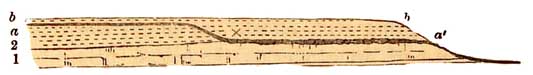
1, Chalk without flints. 2, Chalk with flints, a a, the present surface of the ground marked by a
dark line. b b, an old surface of ground, marked by a light line. Between a a the surface is
covered by accumulated flints, the thickness of which is greatest where the line is thickest
between a' and x, above which surface a greater proportion of chalk has been dissolved and
disappeared.
An irregular mixture of clay with flints, often several feet thick, is also frequent on the surface
of the Chalk Downs on both sides of the valley of the Thames. The flints, though sometimes
broken, are in other respects of the shape in which they were left by the dissolving away of the
Chalk, and the clay itself is an insoluble residue, originally sparingly mingled with that
limestone.
There is no doubt but that the plateaux of Carboniferous Limestone of the Mendip Hills, of
Wales, of Derbyshire, and of the north of England, have suffered waste by solution, equal to that
of the Chalk, only from the absence of flints in these strata we have no insoluble residue by
which to estimate its amount. In Lancashire, north of Morecambe Bay, in Westmoreland, and in
Yorkshire, east, north-east, and northwest of Settle, the high plateaux of limestone are often
for miles half bare of vegetation. The surface of the rock is rough and rugged from the effects of
rain-water and the carbonic acid it contains; looking, on a large scale, like surfaces of salt or
sugar half dissolved. The joints of the rock have been widened by this chemical
[562 Solutions in the Sea.]
action, and it requires wary
walking, with your eyes on the ground, to avoid, perhaps, a broken leg. The
Oolites must have suffered in the same way, especially where not covered
by Boulder-clay; for, it must he remembered, that such effects are chiefly
the result of the exposure of limestones on the actual surface of the ground.
Let me, in concluding this chapter, once more recall to the mind of the half-instructed reader
that the sea is the final recipient of all invisible solutions and of all visible sentiments.
All mountain rivers lost, in the wide home
Of thy capacious bosom ever flow.
Rain and rivers are the unwearied destroyers of all lands, aided by the restless beating of the
waves on rock-bound coasts. These destroy but to reconstruct new strata, by the upheaval of
which future lands shall rise. As the Ocean is now, so has it been throughout all authentic
geological history, and
Its voice mysterious, which whoso hears,
Must think of what will be, and what has been
is always present to the mind of the physical geologist, ever since the time when John Ray, in
1691, published his far-seeing work 'On the Wisdom of God manifested in the Works of
Creation.'