[590]
CHAPTER XXXV.
INDUSTRIAL PRODUCTS OF THE GEOLOGICAL FORMATIONS—ORIGIN OF LOBES—QUANTITIES
OF AVAILABLE COAL IN THE COALFIELDS—ORIGIN OF THEIR BASIN-SHAPED FORMS—CONCEALED
COAL-FIELDS BENEATH PERMIAN, NEW RED, AND OTHER STRATA—SUMMARY.
To enter into detail upon the peculiar effect of geology on the industry of the various races or
the populations of different districts, would lead me far beyond the proposed scope of this work.
I shall, therefore, only give a mere outline rather than attempt to exhaust the subject.
First, let us turn to the older rocks. In Wales, as I have already stated, these consist to a great
extent of slaty material. The largest slate quarries in the world lie in the Cambrian rocks of
Caernarvonshire. One single quarry, that of Penrhyn in Nant Ffrancon, is half a mile in length,
and more than a quarter of a mile from side to side. Other quarries of equal importance
collectively occur in the Pass of Llanberis, and there are large quarries in the same strata at
Nant-y-llef, but none of these are of the same vast size. Important quarries also lie in the Lower
Silurian rocks near Ffestiniog in Merionethshire, and there are large slate quarries in the
Wenlock shale, near Llangollen, and others of minor note scattered about Wales, but always in
Cambrian or Silurian rocks.
[Slate Quarries. 591]
In these districts there is a large population which is chiefly supported by the quarrying and
manufacture of slates. The Penrhyn slate quarry, near Bangor, presents a wonderful spectacle
of industry. It is about half a mile in length, and a quarter of a mile wide, and forms a vast
amphitheatre, which is worked all round, on one side in thirteen high and broad terraces, like
the steps of a Titanic stair. The periodical blastings sound like the firing of parks of artillery.
Vast mounds of rubbish, the waste of the quarry, cover the hills on either side. More than
3,000 men are there employed in the making of slates, which are exported to all parts of the
world. The quarries at Llanberis employ nearly an equal number of men; and the rubbish there
shot down the high slopes into Llyn Peris was lately rapidly destroying the beauty of one of the
most romantic lakes in Wales, and unless the waste be disposed of on the hill-sides, it threatens
in the long run to fill Llyn Peris from end to end. The same ruthless disposal of waste material
has of late years been exercised on the south-western side of Llyn Padarn, in long banks of ugly
shingle, that encroach on the water of the lake and spoil the natural curving symmetry of its
shore. Areas occupied by water are often considered to be places specially designed for the
accommodation of rubbish, and if the quarries on the Dolbarn side of the lake were successful
and largely worked, in time it might be quite. possible to fill the whole of that beautiful sheet of
water with an unsightly debris of slate.
In Merionethshire, near Ffestiniog, some slate quarries are worked in caverns and some in open
day, The number of men and boys employed in the Ffestiniog
[592 Slate Quarries.]
district in January 1872 was about 3,350.1 There are also slate quarries in South Wales,
but few of them have been worked to much advantage, and in Cumberland, where slates are or
have been worked in the green slates of the volcanic rocks of the Lower Silurian series. The
material composing these slates is simply very fine volcanic dust, hardened by intense
pressure, and rendered fissile by slaty cleavage.
In Scotland, in the small island of Easdale, in the Firth of Lorn, there are slate quarries that
have been worked for many years, which produce a good, coarse-grained slate, but they are of
small importance compared with the immense quarries of North Wales. It is probably not an
over-estimate to say that about 15,000 men are employed in the slate quarries of Britain,
involving, perhaps, the direct support of about 50,000 people.
So steady is the profit sometimes derived from slate quarries, that every here and there in
North Wales, where the rocks are more or less cleaved, speculators go to work, and opening
part of a hill-side, find a quantity of rotten stuff, or of slate full of iron pyrites, or cut up by
small joints, or imperfectly cleaved; and after a time, when money runs short, they sell the
property to other speculators, who sometimes ruin themselves in turn.
In various districts of Great Britain the rocks abound in the ores of certain metals, which,
generally occurring in hilly regions, the workers in these mines are rarely congregated in
great crowds like the slate quarriers of North Wales, or the miners of coal and iron. I will first
allude to the case in which the mineral wealth is derived from what are termed lodes, or
1 This fact was supplied to me by the kindness of Mrs. Percival of Bodâwen.
[Lodes and Gold. 593]
fissures in the rocks, sometimes
running for miles, and more or less filled with quartz, calc-spar, and ores
of metals, which yield our chief supplies of copper, tin, zinc, and lead.
It is worthy of remark that these lodes are almost wholly confined to our oldest or Palæozoic
rocks. The Devonian rocks are intersected by them in Devon and Cornwall, arid the Lower
Silurian formations in Wales, Cumberland, the Isle of Man, and the hills of the south of
Scotland, and here and there throughout the Highlands. In the Carboniferous Limestone they are
also largely worked in North Wales, Yorkshire, and Derbyshire.
The chief districts in England where copper and tin are found are in Devon and Cornwall; and in
the Lower Silurian rocks of Wales, especially in Cardiganshire and Montgomeryshire, there are
ores of copper, and many lodes highly productive in ores of lead, some of which are rich in
silver. No tin mines occur in that district. Gold also has been long known in Merionethshire,
between Dolgelli, Barmouth, and Ffestiniog, sometimes, as at Clogau, in profitable quantity, but
generally only in sufficient amount to show reason for starting companies which occasionally
lure unwary speculators to their loss. This Welsh gold is found in lodes generally in and near
the base of the Lingula flags, which in that area are talcose, and pierced by eruptive bosses of
igneous rocks and greenstone dykes.
In older times extensive gold mines were worked in Caermarthenshire at the Gogofau (ogofau,
caves), near Pumpsant, between Liandovery and Lampeter. These excavations were first made
open to the day in numerous irregular extensive quarryings and caverns, where the goldbearing quartz-veins and strings were
[594 Gold and Lead.]
followed into the hill. So extensive are these old works, that a minor valley was in the course of
ages scooped out in the hill-side, and in the wood close by there is a deep artificial excavation
now called Cwm-henog, which in English means Old-cave-valley. Later, lofty well made
galleries were driven, which cut the lodes deeper underneath. Gold was also found in washings of
the superficial gravel, for more than a mile in length, on the banks of the river Cothy, and in
the little upland valley that runs from the Gogofau towards the village of Cynfil Cayo. The well
cut galleries are Roman, but it has been surmised that the ruder caverns date from more
ancient British times. The washing of the gravels for gold may probably be both of the old
British and Roman ages, and for aught that is known the mines may have been worked in both
ways in later times. It is not many years since the quartz veins were again systematically
worked by an enterprising and skilful miner, but though gold was got, the result was not
sufficiently profitable to warrant the continuance of the work.
The huge excavations must have made ugly scars on the hills in the days when they were freshly
worked, but time has healed them. The heaps of rubbish are now green knolls, and gnarled oaks
and ivy mantle the old quarryings.
In the Carboniferous Limestone districts of North Wales, Derbyshire, Lancashire, and the
Yorkshire dales, there are numerous lead mines; and, as I have already said, lead ore occurs in
the underlying Silurian strata, as in South Wales, and also in the Lead Hills in the south of
Scotland, where lead associated with silver, and even a little gold, has long been worked.
I must now endeavour to give an idea of what a lode is. A lode is simply a crack, more or less
filled with
[Lodes. 595]
various kinds of mineral matter, such as layers and nests of quartz, carbonate of lime,
carbonate of copper, sulphide of copper, sulphide of lead, oxide of tin, or with other kinds of
ores. Various theories have been formed to account for the presence of ores in these cracks.
Formerly, the favourite hypothesis was, that they were formed by sublimation from below,
somehow or other connected with the internal heat of the earth; and the ores were supposed to
have been deposited in the cracks through which the heated vapours passed. A great deal also has
been said on the effect of electric currents passing through the rocks, and aiding in depositing
along the sides of fissures the minerals which were being carried up by sublimation, or were in
solution in waters that found their way into the fissures. I dare not utter any positive statement
on the question, but my opinion is that the ores of metals in lodes have generally been deposited
from solutions.
We know that water, especially when warm, can take up silica in solution and deposit it, as in
the case of the Geysers in Iceland; and we also know that metals may, in some states, be held in
solution in water, both warm and cold. This is proved by the accurate results of chemists, who,
it is said, have detected silver, gold, and copper in solution in sea water. We must remember
that when the lodes or cracks were originally formed, those parts of them that we explore were
not so near the surface as we now see them; but in a great many cases they lay deep underneath,
covered by thousands of feet of rock that have since been removed by denudation. They were
probably, in all cases, channels of subterranean filtration, both in their upper portions that
have been removed by denudation, and in the parts originally deeper that now remain
[596 Iron.]
It is not unlikely, also, that these subterranean waters must often have been warm, seeing that
they sometimes lay deep in the interior of the earth, and came within the influence of internal
heat, whatever may be its origin. If so, it is all the more likely that the ores which we meet
with in these cracks or lodes were formed by infiltration of solutions, followed by deposition;
for strings of copper, lead, and tin, for example, occur in the mass, just in the same way that
we find mixed with them strings of carbonate of lime or quartz. This being so, then, just as the
lime and silica may have been derived from the percolation of water through the rocks that form
the country on each side of the lode, so the metalliferous deposits seem to have been derived
from metalliferous matter minutely disseminated through the neighbouring formations. We are,
however, still in the dark as to many of the conditions under which the process was carried on.
Ores of iron are common in lodes, and in hollows or pockets, both in the limestones of the
Devonian and Carboniferoiis periods. In North Lancashire, at and near Ulverstone, rich
deposits of hæmatite lie among the joints and other fissures of the limestone, and often fill large
ramifying caverns deep underground. A vast trade has sprung up in the district in consequence
of these discoveries within the last twenty-five years.
In the Coal-measures, however, we have our greatest sources of mineral wealth, because they
have been the means of developing other kinds of industry besides that which immediately arises
from the discovery of the minerals which the Coal-measures contain. In the great coalfields of
this formation occur all the beds of coal worth working in Britain. In the South Wales coalfield
there are more than 100 beds of coal, about
[Coal. 597]
70 of which are worked somewhere or other. The quantity of available coal in that coalfield has
been estimated by Mr. Vivian and Mr. Clark at about 36,500 millions of tons. In the Forest of
Dean at least 23 beds of coal occur; and the quantity untouched and still available has been stated
by Mr. Dickinson to be 265 millions of tons. In the Bristol and Somersetshire coalfields, where
there are about 87 beds of workable coal, according to Mr. Prestwich, the quantity of coal still
available is said to be nearly 4,219 millions of tons. In South Staffordshire, in the south part of
the field, there are seven well-known beds, one of them 40 feet thick, and a greater number in
the north; and in Coalbrook Dale there are 18 beds, all partly worked. The unexpended portions
of these, added to the available coals of the Forest of Wyre and Clee Hill coalfields, amounts to
nearly 2,000 millions of tons still available, as estimated by Mr. Hartley. In Leicestershire
there are about 30 beds of coal over one foot thick, and Mr. Woodhouse states that nearly 837
millions of tons are available; and in Warwickshire, where five chief beds are worked, about
458* mfflions. In Nottinghamshire, Derbyshire, and Yorkshire, one large coalfield, about 19
beds are worked somewhere or other in the coalfield, and, according to Mr. Woodhouse, more
than 18,000 millions of tons are still available. In North Staffordshire, there are about 28
workable beds of wellknown coal, and others besides not yet worked, and it is stated by Mr.
Elliot that 4,826 millions of tons still lie there at available depths. In Lancashire and Cheshire
more than 40 beds of coal over one foot of thickness are known, many of them of great value, and
about 5,636 millions of tons according to
[598 Coal and Coal Miners.]
Mr. Dickinson are still available. In North Wales there are probably about 41 beds of coal over
one foot in thickness, and according to Mr. Dickinson more than 2,100 mfflions of tons may
Still be extracted. In the Northumberland and Durham coalfield at least 9 beds are worked, and
the amount still available is about 10,000 millions of tons, according to Air. Foster; and in
Cumberland the same authority states that about 405 millions of tons still remain unworked
and available.
In the foregoing estimates, taken from the Coal Commission Report (1871), all coals over one
foot in thickness are included, and it has been assumed that all coals under 4,000 feet in depth
may be available, though this may possibly be an over-estimate as to the depth at which coals
may be worked, in consequence of increase of temperature as we sink to lower depths. The total
amounts to more than 90,000 millions of tons.
The population employed in working coal-pits was said by the Inspectors of Coal-mines in
1870 to be 350,894 persons, and the quantity of coal raised in the same year is calculated by
Mr. Hunt to have been about 110 millions of tons. In 1875, the coal-pit population was
535,845, and in 1876, 515,845. The quantity of coal raised in 1875 was 133,306,485 tons,
extracted from 4,445 collieries, and in 1876, 134,125,166 tons, from 4,329 collieries.
These figures are taken from the annual statistics compiled by the Inspectors of Mines, and a
curious calculation is made by Mr. Thomas Bell, that if all the coal raised in 1876 were
averaged at 12 inches thick, it would require 158 square miles of coal to yield the amount given
above. A statement such as this brings the quantity more
[Coal Basins. 599]
vividly before the mind than figures, or words, viz. one hundred and thirty-four millions, one
hunched and twenty-five thousand, one hundred and sixty-six tons.
Besides coal and iron, the Coal-measures yield quantities of clays, which are of considerable
value. The chief of these is fire-clay, which is used so largely in the manufacture of crucibles
and fire bricks, and in furnaces.
If we look at the geological map of England, we see that large patches are coloured black. These
are the Coal-measure districts of Great Britain. Some of these coalfields, as for instance, the
coalfields of South Wales and the Forest of Dean, lie obviously in basin-shaped forms, and the
coal-beds and other strata crop to the surface all round the basin. But in other parts of England,
the coal-formation does not occur in obvious basins, but seems merely to form a portion of the
ordinary surface of the country. Nevertheless, the basin-shaped form of the Coal-measures is
often continued under the overlying Permian and New Red formations, one half or more of these
basins being hidden from view, and buried under hundreds of feet of more recent strata that lie
uncomformably upon them. The reason of this is that the Carboniferous strata were disturbed
and thrown into anticlinal and synclinal folds before the beginning of Permian and New Red
Sandstone times, as shown in fig. 115, p. 601.
The coalfields marked No. 1 now show at the surface. Strata marked 2 separate them. These
consist of Carboniferous Limestone lying in an anticlinal curve, as in Derbyshire, and part of
the original coalfield shown by the dotted lines 3, in old times covered 2. The remaining parts of
this original coalfield on the east
[600 Coal.]
and west are now partly covered
by Permian and New Red Sandstone rocks 4, shrouding parts of the strata that
lie in synclinal curves. The high rising strata of the upper part of the
anticlinal curve were destroyed by denudation, and great part of the synclinal
curves have been preserved because they were bent down so low, and partly
covered by newer rocks, and have therefore been protected from the wasting
effects of rain, rivers, and the sea in older times. This, I repeat, is the
reason why so many coalfields lie in basin-shaped forms. And this form is
quite independent of Permian and Secondary strata lying accidentally on the
coalbeds. Thus the South Wales and Forest of Dean coalfields were never covered
by these formations, and both are basin-shaped, and form with the Bristol
and Mendip Coalfield parts of one original coalfield, now turned into three
coal-basins by disturbance and denudation.
North of South Wales and Dean Forest all the other coalfields of England, and I think I may add of
Scotland, probably once formed one coalfield; and these have been separated by disturbances
which threw their strata into long anticlinal and synclinal curves. The Staffordshire, North
Wales, and Lancashire coalfields were certainly one, and these were united to the
Warwickshire, Leicestershire, and Nottingham and Derbyshire coalfields, which again joined
that of Durham and Northumberland, which again was united to the coalfields of Cumberland,
and probably of Scodand. They have since been disjoined by curvature of the strata combined
with denudation, and the Northumberland and Yorkshire coalfields are now independent basins,
partly buried under Permian and New Red Sandstone strata. And so, of the other visible
coalfields,Warwick, Leicester,
[601]
FIG. 115.
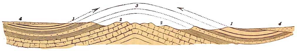
Diagram showing the Origin of the Basin-shaped form of many Coalfields.
1. Coalfields showing at the surface in part. 2. Carboniferous Limestone. 3. Anticlinal curve
between the two Coalfields, which were once joined. 4. Permian and New Red strata covering
parts of the two basin-shaped Coalfields.
[602 Faults and Denudations.]
South Stafford, North Stafford, Cheshire, Lancashire, and the North Wales coalfields, are still
probably one or almost one coalfield, only great parts of them are buried and concealed deep
under Permian and New Red strata, in some places several thousand feet deep.
Thus it sometimes happens, by a combination of the curvature of strata and faults, that only by
a series of geological accidents have the Coal-measures been brought to the surface and exposed
to view. We may take the South Staffordshire coalfield as an example, where the New Red
Sandstone and Permian rocks are thrown down against the coalfield on both sides. Originally,
before these faults took place, the New Red Sandstone and other rocks spread entirely over the
surface. The New Red Sandstone and Marl, where thickest, are more than 2,000 feet thick;
above it lies the Lias, 900 to 1,500 feet thick; then comes the Oolites, and lastly, all the
Cretaceous strata. This enormous mass of superincumbent strata, once lying above the South
Staffordshire Coal-measures, was afterwards dislocated by faults, which brought the lower
Permian and New Red portions of them down against the sides of the present coalfield. A vast
denudation ensued, whereby many of the formations nearest the surface were removed, and the
whole country was worn down to one comparatively general level. It is by such processes that
some of our large and productive coalfields have been exposed at the surface. Hence we now find
a great manufacturing population all centred in areas (like those of South Staffordshire,
Warwickshire, and Ashby-de-la-Zouch) which might never have been known to contain
coalfields, had it not been for the geological accidents of those faults and denudations which I
have explained.
[Coal-fields and Population. 603]
In my report as a member of the Coal Commission (1871), I have shown that under Permian
and New Red strata, north of the Bristol coalfield, there may probably be about 65,000
millions of tons of coals available, at all events under 4,000 feet in depth, and to this Mr.
Prestwich has added 400 millions of tons for the Severn Valley on the south side of the estuary.
The busy population that now covers the coalfields, and to which so many railways converge,
may therefore some day spread over adjoining agricultural areas, and render them as wealthy,
smoky, and repulsive to the outward eye as many visible coalfields now are. Between the mouth
of the Firth of Clyde and the mouth of the Firth of Forth the whole country is one great coalfield,
and this is the part of Scotland where the population is thickest. Bordering Wales and the
mountains of Lancashire and Derbyshire, on the east and west, are three great coalfields, and
these districts also contain dense populations. Further north lies the great Newcastle coalfield,
where, again, the population is proportionately redundant. All the central part of England,
which is dotted over with coalfields, teems in like manner with inhabitants. The South Wales
coalfield, which is the largest of all, however, does not, except in places. such as Swansea,
Llanelly, Dowlais, Merthyr Tydvil, and other centres, show everywhere the same concentration
of population. A great part of this area has till lately not been opened up by railways, and the
coal has been heretofore not worked to the same extent as in the coalfields of the middle and
northern parts of England, which have been extensively mined for a longer period.
Some years ago, after the publication of Mr. Hull's 'Coalfields of Great Britain,' Professor
Jevons, in a
[604 Duration of Coal.]
work 'On the Coal Question,' showed that if the increase of our population goes on as it has been
doing in years past, and if the productive industry of the country keep pace with the population,
the whole of the coal now available in the country would be exhausted in 110 years. Mr. John
Stuart Mill, taking alarm, in his place in Parliament urged upon the nation to act as worthy
trustees for their descendants, to save money while there is yet time, and to pay off as much as
possible of the national debt; and by-and-by, at the instance of Mr. Vivian, a Coal Commission
was appointed to examine into this alarming state of affairs.
The result as regards the duration of coal was stated in the three following hypotheses :—the
first is, that the population and manufactures of the country have nearly attained a maximum
amount, or will merely oscillate without advancing. In this case our coal may last for about
1,273 years, an opinion to which Mr. Hunt of the 'Mining Record' Office still adheres. The
second, according to Mr. Price Williams, is this :—The population of Great Britain in 1871 was
26,943,000. According to a given law of increase, in the year 2231, the population may be
131,700,000, in fact, near 132,000,000, or rather more than five times the present
number. It is hard to realise this crowded population in our little country, but allowing the
assumption to be correct, in a hundred years from 1871 the population of Britain would be
very nearly 59,000,000, and the home consumption of coal 274,200,000 tons a year, in
which case our coal will only last about 360 years. A third view is that adding 'a constant
quantity equal to the annual increase (of consumption) of the last 14 years, which we may take
at 3,000,000
[Smoke. 605]
of tons . . . . at the end of a hundred years the consumption would be 415,000,000 tons per
annum, and the now estimated quantity of coal available for use would represent a consumption
of 276 years.'1 I offer no positive opinion on this subject, but I suspect the first view is likely
to be nearer the truth than the last.
However this may be, it is certain that some day or other our coal must be practically
exhausted, but so many things may happen ere that time that it is doubtful if even we, the
trustees of the future, need to concern ourselves very much about the matter. Personal
prudence, selfishness, or the love of money, will not be hindered by anxiety about people who
are to live hundreds of years hence, and great part of England will still continue smoky as long
as coal lasts in quantity, or at all events till the laws are enforced against the production of
unnecessary smoke. All the centre of England is thick with it, floating from every coalfield, and
from all the dependent manufacturing towns. The heaths and pastures of Derbyshire and
Yorkshire between the two great coalfields are blackened by smoke, and even in the rainiest
weather the sheep that ought to be white-wooled are dark and dingy. Every coalfield in England
as it happens, is a centre of pollution to the air. But this does not affect the manufacturing
population of these districts excepting in a sanitary, and therefore in a moral, point of view,
and this state of affairs is too apt to be considered unavoidable in the present state of economics
and unscientific practice, though it is not so of necessity.
What will be the state of Britain when all the coal is gone? The air at all events will be
purified, and the
1 'Report of the coal Commissioners,' pp. 16 and 17.
[606 coal Exhausted.]
hideous heaps of slag, so suggestive of wealth, power, culture, and prosperity, that disfigure
South and North Staffordshire, and all the other iron-making districts, will in time crumble
into soil, and, covered by grass and trees, they will one day become beautiful features in the
landscape; for man cannot permanently disfigure nature. Even when this thing takes place will
there be any necessity for the country being reduced to absolute poverty? Our mountain lands,
like the Schwarzwald, may be more woody than at present, and yield supplies of fuel, the plains
and tablelands more richly cultivated, and who knows besides what motive powers may by that
time be economised other than those that result from the direct application of artificial heat?
Holland and the lowlands of Switzerland without coal are two of the happiest and most
prosperous countries in Europe, and it appears as if Italy would follow in their steps, but on a
larger scale. In the far future, Britain may still be prosperous, powerful, and happy, even
though all its coal be exhausted.
Of late years a great deal of valuable iron ore has been obtained from the top of the Lower Lias
and from the Maristone of Yorkshire, and this tends still more rapidly to exhaust our coal. The
result has been the rapid growth of the enterprising district and port of Middlesborough on the
Tees. At night the whole country is aglow with iron furnaces, and the time may arrive when the
beautiful Oolitic valleys of North Yorkshire will become a black country as smoky as the
Lancashire and Staffordshire coalfields.
The Northampton Sands of the Oolites also yield large quantities of silicious ironstone. It must
not, however, be supposed that ironstone is everywh'ere plentiful in that formation, nor yet in
the Maristone,
[Iron Ores. 607]
and far less in the Lower Lias. I have seen prospectuses of mining companies in the middle of
England, in which it was stated that all the ironstone bands of Middlesborough are present in
ground where scarce an ounce of them exists.
In older times, in the Weald of the south of England, a considerable amount of iron ore used to be
mined and smelted with wood or charcoal, before the Coal-measures were worked extensively,
and when the Weald was covered to a great extent with forest. Then the chief part of our iron
manufactures was carried on in the south-east of England. Indeed, late in the last century, there
were still iron furnaces in the Weald of Kent and Sussex. The last furnace is said to have been at
Ashburnham; and here and there we may even now see heaps of slags overgrown with grass, and
the old dams that supplied the water which drove the water-wheels that worked the forges of
Kent and Sussex. It is said that cannon used in the fight with the Spanish Armada came from this
district; and the rails round St. Paul's and other churches of the time of Sir Christopher Wren
were forged from the Wealden iron.
I have already remarked that a large part of the wealth which we owe to our Carboniferous
minerals, arises, not so much from the commercial value of the coal and ironstone of the
coalfields, as from the fact that they form the means of working many different branches of
industry. To the vast power which steam has given us, very much of our extraordinary
prosperity as a nation is due. Yet were it not for our coal-beds, the agency of steam would be
almost wholly denied to us. Arid hence it is that our great manufacturing districts have sprung
up either in, or in
[608 Kaolin and other Clay.]
the vicinity of coalfields. There iron furnaces glare and blow day and night, there are carried on
vast manufactures in all kinds of metal, and there our textile fabrics are chiefly made. In these
busy scenes a large part of the population of our island finds employment, and thence we send to
the farthest parts of the earth those endless commodities which, while they have supplied the
wants of other countries, have given rise in large measure to the wealth and commerce of our
own.1
There are some other geological formations which afford materials for manufactures other than
coal and ores of metals. Thus, in the south-west of England, in the granitic districts of Devon
and Cornwall, a great proportion of the finer kinds of clays occur, which are used in making
stoneware and porcelain. In Devon and Cornwall the decomposition of granite affords the
substance known by the name of Kaolin, from which all the finer porcelain clays are made. It is
formed by the disintegration of the felspar of granite. This felspar consists of silicates of
alumina, and soda or potash. The soda and potash are comparatively easily dissolved, chiefly
through the influence of carbonic acid in the rain-water that falls upon the surface; and the
result is that the granite decomposes to a considerable depth. In some cases I have seen granite,
undisturbed by the hand of man, which for a depth of twenty feet or more might be easily dug out
with a shovel. Owing to this decomposition, a portion of the felspar passes into kaolin, which is
washed down by rain into the lower levels, where, more or less mixed with quartz
1 At least it was so till lately, and there is no reason to suppose that the mining and
manufacturing industry of Britain has declined except for a time.
[Kaolin and other Clays. 609]
and the other ingredients of granite, it forms natural beds of clay. This is dug out, and the clay
is transported chiefly to the district of the Potteries in North Staffordshire. The same process
is sometimes secured by art, when the decomposed granite being dug out, is washed by artificial
processes, and the more aluminous matter is separated from the quartz with which it was
originally associated. Then, in the Potteries, it is turned into all sorts of vessels-fine
porcelain, stoneware, and common-ware in every variety of size, and form, and texture.
In the Eocene tertiary beds, in the neighbourhood of Poole, there are large lenticular beds of
pipe-clay, interstratified with the Bagshot Sand. Great quantities of this clay are exported into
the Pottery districts to be made into the coarser kind of earthenware, and they are also mixed
with the finer materials from Devon and Cornwall, to make intermediate qualities of stoneware and china.
But in addition to clay, the chalk is brought into requisition to furnish its quota of material for
this manufacture. The flints that are found embedded in the chalk, chiefly in layers, are also
transported to the Potteries, and ground up with the aluminous portions of the clay, since it is
sometimes necessary to use a certain proportion of silica in the manufacture of porcelain.
Many other formations, such as the Old and New Red Marls, are also of use when clay is required
for the manufacture of bricks. The Oolitic and Liassic strata are to a great extent composed of
clay, such as Lias Clay, Fullers' Earth Clay, Oxford and Kimeridge Clay; there is also the Weald
Clay, and the Gault lies in the middle of the Cretaceous strata. The Boulder-clay
[610 Jet, Glass-sand, &c.]
is also often used in manufactures, and the silts of the Wash and of many another river. An
abundance of material is found in all of these formations for the manufacture of bricks,
earthenware pipes, and so on; and it is interesting to observe how in this respect the
architecture of the country is apt to vary according to the nature of the strata of given areas. In
Scotland and the north of England, where hewable stone abounds, almost all the houses are built
of sandstone, grey and sombre; in many of the Oolitic districts they are of limestone, and
generally lighter and more graceful; while on the Red Marls, Lias, and in the Woodland area of
the Weald we have still the relics of an elder England in those beautiful brick and timbered
thouses that speak of habits and manners gone by.
In the upper Lias clay in Yorkshire, beds of lignite and jet are found near Whitby, which
locally forms a not unimportant branch of manufacture.
The glass-sand used in this country is chiefly derived from the Eocene beds of the Isle of Wight,
and from the sand-dunes on the borders of the Bristol Channel. In the Isle of Wight, the sandy
strata lie above the London Clay, and are the equivalent of part of the Bagshot sands. They are
remarkably pure in quality, being formed of fine white silicious sand. These sands are largely
dug and exported to be used in glass-houses in various parts of the country, as in Birmingham
and elsewhere.
A large proportion of the cement-stones of our country comes from the Lias limestone. These
limestones are not pure carbonate of lime, but are formed of an intermixture of carbonate of
lime and aluminous matter. It is found by experience that the lime from this kind of limestone
is peculiarly adapted for setting
[Building-Stones. 611]
under water. Hence the Lias limestone has always been largely employed in the building of piers
and other structures that require to be constructed under water. Cement stones are also found to
some extent in the Eocene strata, and are obtained from nodules dredged from the sea-bottom at
Harwich, and the south of England. These are transported hither and thither, to be used as
occasion may require.
The chief building stones of our country, of a hewable kind, are the limestones of the Oolitic
rocks, the Magnesian Limestone, the Carboniferous Limestone, the Carboniferous sandstones,
and the sandstones of the Old and New Red series. The Caradoc Sandstone, also in Shropshire near
Church Stretton, yields a good building stone. The chief Oolitic building stones are from the Isle
of Portland and the Bath Oolite. St. Paul's and many other churches in London were built of
Portland stone, and the immense quantities of rejected stones in the old quarries, show how
careful Sir Christopher Wren was in the selection of material. The Bath stone also affords a
beautiful yellow limestone, which comes out of the quarries in blocks of great size, and is easily
sawn and hewn into shape. Nearly the whole of Bath has been built of this stone, and it has been
largely used in Westminster Abbey and other buildings in London. Excellent building stones are
also got from the Inferior Oolite limestone, especially in the neighbourhood of Cheltenham, from
the Cotswold Hills.
In England the Magnesian Limestone is extensively quarried for building purposes. It is of very
various qualities, sometimes exceedingly durable, resisting the effects of time and weather, and
in other cases decomposing with considerable rapidity. The Houses of
[612 Building Sones.]
Parliament were chiefly built of this stone. In districts where it occurs, in Nottinghamshire
and Yorkshire, there are churches, and castles such as Conisbro', built of it, wherein the edges
of the stones are as sharp as if fresh from the mason's hands. You can see the very chisel-marks
of the men who built the castle, in days possibly before, but certainly not long after the landing
of William the Conqueror.
The Carboniferous Limestone also is an exceedingly durable stone. The Menai bridges were built
of it. In Caernarvon Castle the preservation of this limestone is well shown. The castle is built
of layers of limestone and sandstone, the sandstone having been chiefly derived from the
Millstone Grit, or from sandstones interstratified with the limestone, and the limestone from
quarries in Anglesea, and on the shores of the Menai Straits. The limestone has best stood the
weather. Sandstone, though durable, is rarely so good as certain limestones, which, being
somewhat crystalline, and sometimes formed to a great extent of Encrinites, also essentially
crystalline in structure, have withstood the effect of time.
The Carboniferous Sandstones in Lancashire, Derbyshire, Yorkshire, and in Wales and Scotland,
afford large quantities of admirable building material, which has been used almost exclusively
in the building of Leeds, Edinburgh, Glasgow, and many other towns. Some of it is exceedingly
white, is easily cut by the chisel, and may be obtained in blocks of immense size. But in some of
the beds there is so much diffused iron, not visible at first sight, that in the course of time this,
as it oxidises, produces stains which discolour the exterior of the buildings.
Unlike limestones, basalts and other hard and tough
[Road Metal. 613]
rocks, such sandstones as the Millstone Grit and Gannister beds of the Coal-measures, are ill
adapted for macadamising roads, for traffic rapidly grinds it into its original state of loose sand.
Nevertheless, in some regions they have nothing else to use, and to obviate its defects the
following process is used near Barnsley and in other parts of Yorkshire. The rocks in question
were made from the debris of granites and gneiss, similar to those of the Scotch Highlands. The
stone being quarried in small slabs and fragments, is built in a pile about 30 feet square, and
12 or 14 feet high, somewhat loosely; and while the building is in progress, brushwood is
mingled with the stones, but not in any great quantity. Two thin layers of coal, about 3 inches
thick, at equal distances, are, so to speak, interstratified with the sandstones, and a third layer
is strewr over the top. At the bottom facing the prevalent wind, an opening about 2 feet high is
left, something like the mouth of an oven. Into this brushwood and a little coal is put and lighted.
The fire slowly spreads through the whole pile, and continues burning for about six weeks.
After cooling the stack is pulled down, and the stones are found to be vitrified. Slabs originally
flat have become bent and contorted like gneiss, and stones originally separate, get, so to speak,
glued together in the process of vitrification, aided by the soda, potash, and iron, which form
part of the constituents of felspar and mica and act as a flux.
In the year 1859 I visited a vitrified fort called Knockfarril, near Strathpeffer in Ross-shire,
'and came to the conclusion that the vitrification had been done of set purpose, and that the effect
had been produced by burning wood.' In the first volume of Dr. John Hill Burton's 'History of
Scotland,' 1866, he
[614 Vitrfied Forts.]
expresses a wish that science would explain the manner in which vitrification of forts was
effected. Having formed the opinion that the Yorkshire method of vitrification most closely
resembled that used by the old fortbuilders, I wrote to Mr. Burton giving an account of it, and
the letter with sundry blunders in geological names is printed in a paper by Mr. John Stuart,
LL.D. in the 'Proceedings of the Society of Antiquaries of Scotland,' 1868-9. All the vitrified
forts in Scotland are either in the Highlands, or in Berwickshire and Galloway, where rocks
easily vitrified abound, and but that there are neither vitrified forts nor native celts in modern
Yorkshire, one would almost be tempted to speculate on the art of vitrification having descended
there, from an ancient Pictish people of the bronze age, such as are supposed by Dr. Julius
Ernest Fodisch to have erected the scorified ramparts of the forts in Bohemia. The vitrification
of rocks in Yorkshire I have thought worthy of being recorded, throwing as it does some light on
the method employed in the construction of forts in times that seem to us to be prehistoric.
The New Red Sandstone also yields its share of building stones, but much of it is very soft and
easily worn by the weather, a notable example of which was seen in the Cathedral at Chester
before its restoration. The white Keuper Sandstone of G-rinshill, north of Shrewsbury, the
Peckforton Hills, and Delamere Forest, is an excellent stone. The Old Red Sandstone is also used
as a building stone in its own area, and, as already stated, the Caradoc Sandstone of Shropshire,
near Church Stretton, yields a beautiful white material.
The rock-salt of Worcestershire and Cheshire is a valuable commodity. It lies in the New Red
Marl,
[Rock Salt and Gypsum. Granites. 615]
low in the series, and, as already explained, was the result of the solar evaporation of an inland
lake, like, for example, the great salt lake near Utah, in the Rocky Mountains, or of the salt
lakes of central Asia. The waters that ran into it contained quantities of salt in solution; and as
the lake had no outlet, and only got rid of its water by evaporation, concentration of the chloride
of sodium ensued, till at length super saturation being induced, precipitation of rock-salt took
place. The same formation yields the greater part of the gypsum quarried in England, though
some also occurs in the Red Marl of the Magnesian Limestone' series.1
In Devonshire and Cornwall, on Shap Fell in Westmoreland, and in Scotland chiefly near
Aberdeen, the granite quarries afford much occupation to a number of people. Now that it has
become the fashion to polish granites, these rocks are becoming of still more importance. But as
they are not so easily hewn as sandstone, they do not come into use as ordinary building stones,
except in such districts as Aberdeen, where no other good kind of rock is to be had. Basalt,
Greenstones, and Feispathic porphyries from North Wales, Scotland, Charnwood Forest, and
other districts in England, are also largely employed for building and road-making, and the
Serpentines of Cornwall and Anglesea, and the Marbles of the Carboniferous Limestone of
Derbyshire, yield beautiful materials for ornamental purposes.
I have now attempted to give an idea of the general physical geography of our country, both in
ancient and
1
For a full account of the physical formation of these deposits, see 'Journ. Geol. Soc.' 1871, vol.
xxvii. pp. 189 and 24L—Ramsay.
[616 Summary.]
modern times, as dependent on its geology. I have described the classification of all the
formations in serial order, and showed the distribution of these rocks over our country, arid in
doing this I have tried to give a sketch of the physical geography of our area, during the
deposition of each successive group of formations. At various times they have all been affected
by disturbances and denudations, and the grand result is, that where most disturbed, hardened,
and denuded, there we have mountainous districts; for the greater prominence and ruggedness of
surface of these regions, arises partly from the hardness of the igneous, metamorphic, and
common stratified rocks, partly from the denudations which they have undergone. The
Secondary and Tertiary rocks being younger and not so much disturbed, have in our country not
been so much denuded, and therefore generally form plains and tablelands.
Moreover, we saw that over all these surfaces, in addition to the vast amount of erosion which
must have been effected in Palozoic, Secondary, and older Tertiary times, renewed denudations,
accompanied by great cold, occurred at a very late epoch. The result of this abrasion has been to
cover the surface more or less with loose superficial detritus, upon which part of the fertility
of portions of the country and the peculiarity of some of its soils depend.
I then passed on to notice what I considered to be a very remarkable result of this last great
denudation, brought about under the influence of ice, by which the chief part—I by no means say
all—but by which the chief part of the lakes of our country have been formed;
nd not of our country alone, but of a large part of the northern, and I have no doubt also of the
southern hemisphere. It is a remarkable thing, indeed, to
[Summary 617]
consider, if true—and I firmly believe it to be true—that so many of those hollows in which lakes lie
have been scooped out by the slow and long-continued passage of great sheets of glacier ice, quite
comparable to those vast masses that cover the extreme northern and southern regions of the
world at this day.
The water-drainage of the country is likewise seen to be dependent on geological structure. Our
larger rivers chiefly drain to the east, and excepting the Severn, the Dee (Wales), the Mersey,
the Solway, and the Clyde, the smaller ones to the west, partly because certain axes of
disturbance happened to lie nearer our western than our eastern coasts. Again, the quality of
water in these rivers depends, as we have seen, on the nature of the rocks over which they flow,
and of the springs by which they are supplied.
Then, when we come to consider the nature of the population inhabiting our island, we find it
also to be greatly influenced by this old geology. The earlier tribes were in old times driven into
the mountain regions in the north and west, and so remain to this day-still speaking their own
languages, but gradually mingling now, as they did before, with the masses of mixed races that
came in with later waves of conquest from other parts of Europe. These later races settling down
in the more fertile parts of the country, first destroyed and then again began to develop its
agricultural resources In later times they have applied themselves with wonderful energy to
turn to use the vast stores of mineral wealth which lie in the central districts. Hence have
arisen those densely peopled towns and villages in and around the Coal-measure regions, where
so many important manufactures are carried on. Yet in the west, too—in Devon and
[618 Summary.]
Cornwall, and in Wales where some of the great Coalmeasure, metalliferous, and slaty regions
lie—there are busy centres of population, where the operations are often directed by, and the
manual labour connected with the mineral products is well done by the original Celtic
inhabitants.
It is interesting to go back a little and inquire what may have been the condition of our country
when man first set foot upon its surface. We know that these islands of ours have been
frequently united to the Continent, and as frequently disunited, partly by elevations and
depressions of the land, and to a great extent, also, by denudations. When the earliest human
population of which we have any traces came, Britain was doubtless united to the Continent.
Such is the deliberate opinion of some of our best geologists, and also that these prehistoric men
inhabited our country along with the great hairy Mammoth, the Rhinoceros, the Cave Bear, the
Lion, the Hippopotamus, and many modern animals—and perhaps, in pre-Glacial times, they
travelled westward into what is now Britain from the Continent, along with these extinct
mammalia. The country was then most probably covered by great forests, swamps, and peaty
flats, unless it may have been that the Chalk downs and the higher mountain-tops were bare.
But in times much later, denudations and alterations of level having taken place, our island
again became disunited from the mainland: and now, with all its numerous firths and inlets, its
great extent of coast, its admirable harbours, our country lies within the direct influence of
that Gulf Stream which softens the whole climate of the West of Europe, and we, a people of
mixed race, Celt, Scandinavian, Angles, and Norman, more or less intermingled in blood, are so
happily
[Summary. 619]
placed that, in a measure, we have the command of a large portion of the commerce of the world,
and send out fleets of merchandise from every port.
And we are happy, in my opinion,, above all things in this, that by an old denudation we have
been dissevered from the Continent of Europe, and our boundaries are clear. Thus it happens
that, free from immediate contact with countries possibly hostile, and not too much biassed by
the influence of peoples of foreign blood, during the long course of years in which our country
has never seen the foot of an invader,1 we have been enabled, with occasional disturbance of
foreign wars and political factions, progressively so to develop our own ideas of religion,
political freedom, and political morality, that we stand one of the freest and most prosperous
countries on the face of the globe.
I have now completed the somewhat arduous task undertaken in preparing this much enlarged
edition of an old book. It is, after all, but a sketch of a large subject, and no one can be more
sensible than I am of its imperfections; but with all its faults and omissions, I think that this
is the first work in which an attempt has been made to trace in detail the absolute connection of
the Physical Geology and Physical Geography of old epochs in Britain with that of the present
day. Right or wrong in some of the questions raised, it is the work of one who, through more
than half a, lifetime, has
'pry'd through Nature's store,
Whate'er she in th' ethereal round contains,
Whate'er she hides
beneath her verdant floor,
The vegetable and the mineral reigns;
1
The small French descents of Pembrokeshire and Ireland do not deserve the name of invasions.
[620 Summary.]
Or else he scans the' globe—those small domains,
Where restless mortals such a turmoil
keep,
Its seas, its floods, its mountains, and its plains:
Let the reader learn from it what he can, and judge of the result.